Salles-Curan
| Salles-Curan | ||
|---|---|---|
| Commune | ||
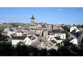 A general view of Salles-Curan | ||
| ||
 Salles-Curan Location within Occitanie region  Salles-Curan | ||
| Coordinates: 44°11′00″N 2°47′16″E / 44.1833°N 2.7878°ECoordinates: 44°11′00″N 2°47′16″E / 44.1833°N 2.7878°E | ||
| Country | France | |
| Region | Occitanie | |
| Department | Aveyron | |
| Arrondissement | Millau | |
| Canton | Raspes et Lévezou | |
| Intercommunality | Lévézou Pareloup | |
| Government | ||
| • Mayor (2008–2014) | Henri Malaval | |
| Area1 | 93.9 km2 (36.3 sq mi) | |
| Population (2008)2 | 1,064 | |
| • Density | 11/km2 (29/sq mi) | |
| Time zone | UTC+1 (CET) | |
| • Summer (DST) | UTC+2 (CEST) | |
| INSEE/Postal code | 12253 /12410 | |
| Elevation |
547–1,084 m (1,795–3,556 ft) (avg. 820 m or 2,690 ft) | |
|
1 French Land Register data, which excludes lakes, ponds, glaciers > 1 km2 (0.386 sq mi or 247 acres) and river estuaries. 2 Population without double counting: residents of multiple communes (e.g., students and military personnel) only counted once. | ||
.svg.png)
Salles-Curan is a commune in the Aveyron department in southern France.
Geography
The lac de Pareloup forms part of the commune's northern border.
The river Céor has its source in the western part of the commune.
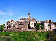
View of Salles-Curan
Population
| Historical population | ||
|---|---|---|
| Year | Pop. | ±% |
| 1962 | 1,443 | — |
| 1968 | 1,538 | +6.6% |
| 1975 | 1,491 | −3.1% |
| 1982 | 1,419 | −4.8% |
| 1990 | 1,277 | −10.0% |
| 1999 | 1,088 | −14.8% |
| 2008 | 1,064 | −2.2% |
See also
References
| Wikimedia Commons has media related to Salles-Curan. |
This article is issued from
Wikipedia.
The text is licensed under Creative Commons - Attribution - Sharealike.
Additional terms may apply for the media files.