Sénergues
| Sénergues | |
|---|---|
| Commune | |
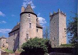 The chateau in Sénergues | |
 Sénergues Location within Occitanie region  Sénergues | |
| Coordinates: 44°36′24″N 2°29′08″E / 44.6067°N 2.4856°ECoordinates: 44°36′24″N 2°29′08″E / 44.6067°N 2.4856°E | |
| Country | France |
| Region | Occitanie |
| Department | Aveyron |
| Arrondissement | Rodez |
| Canton | Lot et Dourdou |
| Government | |
| • Mayor (2008–2014) | Pierre Vernhes |
| Area1 | 44.9 km2 (17.3 sq mi) |
| Population (2008)2 | 487 |
| • Density | 11/km2 (28/sq mi) |
| Time zone | UTC+1 (CET) |
| • Summer (DST) | UTC+2 (CEST) |
| INSEE/Postal code | 12268 /12320 |
| Elevation |
188–664 m (617–2,178 ft) (avg. 550 m or 1,800 ft) |
|
1 French Land Register data, which excludes lakes, ponds, glaciers > 1 km2 (0.386 sq mi or 247 acres) and river estuaries. 2 Population without double counting: residents of multiple communes (e.g., students and military personnel) only counted once. | |
Sénergues is a commune in the Aveyron department in southern France.
Population
| Historical population | ||
|---|---|---|
| Year | Pop. | ±% |
| 1962 | 886 | — |
| 1968 | 898 | +1.4% |
| 1975 | 815 | −9.2% |
| 1982 | 732 | −10.2% |
| 1990 | 608 | −16.9% |
| 1999 | 545 | −10.4% |
| 2008 | 487 | −10.6% |
See also
References
| Wikimedia Commons has media related to Sénergues. |
This article is issued from
Wikipedia.
The text is licensed under Creative Commons - Attribution - Sharealike.
Additional terms may apply for the media files.