Shintotsukawa, Hokkaido
| Shintotsukawa 新十津川町 | |||
|---|---|---|---|
| Town | |||
| |||
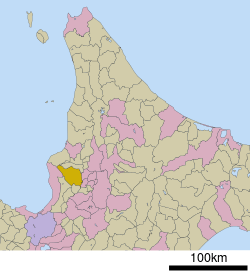 Location of Shintotsukawa in Hokkaido (Sorachi Subprefecture) | |||
 Shintotsukawa Location in Japan | |||
| Coordinates: 43°33′N 141°53′E / 43.550°N 141.883°ECoordinates: 43°33′N 141°53′E / 43.550°N 141.883°E | |||
| Country | Japan | ||
| Region | Hokkaido | ||
| Prefecture | Hokkaido (Sorachi Subprefecture) | ||
| District | Kabato | ||
| Government | |||
| • Mayor | Mitsuru Ueda | ||
| Area | |||
| • Total | 495.62 km2 (191.36 sq mi) | ||
| Population (September 30, 2016) | |||
| • Total | 6,787 | ||
| • Density | 14/km2 (35/sq mi) | ||
| Symbols | |||
| • Tree | Japanese Yew | ||
| • Flower | Azalea | ||
| Time zone | UTC+9 (JST) | ||
| City hall address |
301-1 Chūō, Shintotsukawa-chō, Kabato-gun, Hokkaidō 073-1103 | ||
| Website |
www | ||
Shintotsukawa (新十津川町 Shintotsukawa-chō, "New Totsukawa") is a town located in Sorachi Subprefecture, Hokkaido, Japan.
As of September 2016, the town has an estimated population of 6,787, and a population density of 14 persons per km². The total area is 495.62 km².
In 1890, the people from Totsukawa in Nara Prefecture reclaimed land.
Notable people from Shintotsukawa
- Yoshio Hachiro, politician
External links

- Official Website (in Japanese)
| ||||||||||
| ||||||||||
| ||||||||||
| ||||||||||
| ||||||||||
| ||||||||||
| ||||||||||
| ||||||||||
| ||||||||||
| ||||||||||
| ||||||||||
| ||||||||||
| ||||||||||
| ||||||||||
This article is issued from
Wikipedia.
The text is licensed under Creative Commons - Attribution - Sharealike.
Additional terms may apply for the media files.