Chitose, Hokkaido
| Chitose 千歳市 | |||
|---|---|---|---|
| City | |||
| Chitose City | |||
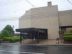 New Chitose City Hall | |||
| |||
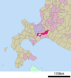 Location of Chitose in Hokkaido | |||
| Coordinates: 42°49′N 141°39′E / 42.817°N 141.650°ECoordinates: 42°49′N 141°39′E / 42.817°N 141.650°E | |||
| Country | Japan | ||
| Region | Hokkaido | ||
| Prefecture | Hokkaido | ||
| Subprefecture | Ishikari Subprefecture | ||
| Government | |||
| • Mayor | Kōtarō Yamaguchi | ||
| Area | |||
| • Land | 594.50 km2 (229.54 sq mi) | ||
| Population (March 31, 2018) | |||
| • Total | 96,475 | ||
| • Density | 162/km2 (209/sq mi) | ||
| Time zone | UTC+9 (Japan Standard Time) | ||
| Tree | Japanese white birch and katsura (Cercidiphyllum japonicum) | ||
| Flower | Azalea and hanashōbu (Iris ensata var. ensata) | ||
| Website |
www | ||


.svg.png)
Chitose (千歳市 Chitose-shi) is a city located in Ishikari Subprefecture, Hokkaido, Japan, and home to the New Chitose Airport, the biggest international airport in Hokkaido and closest airport to Sapporo, as well as the neighboring Chitose Air Base.
As of May 1, 2017, the city has an estimated population of 96,580, with 48,485 households,[1] and a population density of 155 persons per km2. The total area is 594.95 km2. The city was founded on July 1, 1958. The city is notable for having a Peace Pagoda, built by the Japanese Buddhist order Nipponzan Myohoji in 1978.
History
- 1880: The village of Chitose (consisting of a merger of the localities of Chitose, Osatsu, Usakumai, Rankoshi, Izari, Shimamatsu) is established.
- 1897: The village of Eniwa (consisting of the localities of Izari and Shimamatsu) (now a city) splits off.
- 1915: Chitose (consisting of the localities of Chitose, Osatsu, Usakumai, Rankoshi) becomes a Second Class Municipality.
- 1939: Chitose becomes a First Class Municipality.
- 1942: Chitose promoted to town status.
- Post WWII - Chitose hosts a US Air Force base.
- July 1, 1958: Chitose promotes to city status.
Geography
Chitose is one of the gateways to the Shikotsu-Toya National Park, Lake Shikotsu and Mount Tarumae. The city is bounded by Eniwa in the north and by Tomakomai in the south.
Origin of the name
In the Ainu language, Chitose was originally called shikot, meaning big depression or hollow, like Lake Shikotsu which is a caldera lake. In Japanese, this sounded too much like dead bones (死骨 shikotsu), so it was changed to Chitose.[2]
Climate
The hottest and coldest temperatures, respectively, ever recorded are 34.2 °C and -30.7 °C.
| Climate data for Chitose (1981~2010年) | |||||||||||||
|---|---|---|---|---|---|---|---|---|---|---|---|---|---|
| Month | Jan | Feb | Mar | Apr | May | Jun | Jul | Aug | Sep | Oct | Nov | Dec | Year |
| Record high °C (°F) | 8.2 (46.8) |
9.1 (48.4) |
14.4 (57.9) |
24.1 (75.4) |
29.9 (85.8) |
31.4 (88.5) |
33.1 (91.6) |
34.2 (93.6) |
30.5 (86.9) |
24.6 (76.3) |
20.9 (69.6) |
15.0 (59) |
34.2 (93.6) |
| Average high °C (°F) | −1.4 (29.5) |
−0.8 (30.6) |
3.2 (37.8) |
10.7 (51.3) |
16.0 (60.8) |
19.3 (66.7) |
22.4 (72.3) |
24.6 (76.3) |
21.6 (70.9) |
15.8 (60.4) |
8.3 (46.9) |
1.5 (34.7) |
11.8 (53.2) |
| Daily mean °C (°F) | −6.7 (19.9) |
−6 (21) |
−1.2 (29.8) |
5.3 (41.5) |
10.4 (50.7) |
14.5 (58.1) |
18.3 (64.9) |
20.4 (68.7) |
16.5 (61.7) |
10.0 (50) |
3.3 (37.9) |
−3.4 (25.9) |
6.8 (44.2) |
| Average low °C (°F) | −13.9 (7) |
−13.4 (7.9) |
−6.9 (19.6) |
−0.1 (31.8) |
5.2 (41.4) |
10.5 (50.9) |
15.3 (59.5) |
17.1 (62.8) |
11.4 (52.5) |
3.7 (38.7) |
−2.4 (27.7) |
−9.6 (14.7) |
1.4 (34.5) |
| Record low °C (°F) | −30.7 (−23.3) |
−30.3 (−22.5) |
−25.7 (−14.3) |
−14.2 (6.4) |
−3.8 (25.2) |
— | — | — | — | — | −18.1 (−0.6) |
−25.9 (−14.6) |
−30.7 (−23.3) |
| Average precipitation mm (inches) | 39.5 (1.555) |
34.3 (1.35) |
49.9 (1.965) |
70.3 (2.768) |
97.1 (3.823) |
70.4 (2.772) |
127.4 (5.016) |
177.6 (6.992) |
162.8 (6.409) |
109.6 (4.315) |
77.4 (3.047) |
52.8 (2.079) |
1,069.1 (42.091) |
| Average snowfall cm (inches) | 54 (21.3) |
57 (22.4) |
33 (13) |
5 (2) |
0 (0) |
0 (0) |
0 (0) |
0 (0) |
0 (0) |
— | — | — | 149 (58.7) |
| Source: Japan Meteorological Agency,New Chitose Aviation Weather Station[3] | |||||||||||||
Economy
China Airlines operates its Sapporo office on the third floor of the airport building.[4]
The airline Hokkaido Air System was at one time headquartered at the New Chitose Airport in Chitose.[5] Now its head office is on the property of Okadama Airport in Higashi-ku, Sapporo.[6]
Transport
Air
Rail
Muroran Main Line runs through the east of the city but there is no station.
- Chitose Line : Bibi - Minami-Chitose - Chitose - Osatsu
- Chitose Line (branch line) : Minami-Chitose - New Chitose Airport
- Sekishō Line : Minami-Chitose
Road
Chitose is accessed by two expressways with an interchange in the west and another in the north on a separate expressway and the Chitose-Eniwa Junction connecting with the Eastern Hokkaido Expressway in the northwest. Chitose is also linked by National Route 36, National Route 274, National Route 276, National Route 337, and National Route 453.
Education
Chitose also has a university, two high schools, 18 junior high schools, and 10 elementary schools.
Universities
High schools
- Hokkaido Chitose High School
- Hokkaido Chitose Hokuyou High School
Twinnings
Chitose has sister city relationships with:[7]


Notable People
- Chiyotaikai Ryūji, sumo wrestler
References
- ↑ "Official website of Chitose City" (in Japanese). Japan: Chitose City. Retrieved 16 May 2017.
- ↑ Akagi Sanpei (赤木 三兵), Journey of Hokkaido Place Names—Notes on Ainu Language Place Names (北海道 地名の旅—アイヌ語地名解 Hokkaidō Chimei no Tabi — Ainugo Chimei Kai), pp 60 and 79
- ↑ 新千歳航空測候所の天気概況 [Weather records at New Chitose Aviation Weather Station] (in Japanese). Japan Meteorological Agency. December 2012. Retrieved December 17, 2012.
- ↑ "Northeast Asia." China Airlines. Retrieved on August 30, 2011. "Sapporo 3F, New Chitose Airport, Bibi, Chitose City 066-0012, Hokkaido, Japan"
- ↑ "会社概要." Hokkaido Air System. Retrieved on May 19, 2009. "本社事務所 : 千歳市美々新千歳空港ターミナルビル内"
- ↑ "会社概要." Hokkaido Air System. Retrieved on August 30, 2011. "〒007-0880 札幌市東区丘珠町 丘珠空港内"
- ↑ Sister cities of Chitose
External links
| Wikimedia Commons has media related to Chitose, Hokkaido. |
- Official Website (in Japanese)
| ||||||||||
| ||||||||||
| ||||||||||
| ||||||||||
| ||||||||||
| ||||||||||
| ||||||||||
| ||||||||||
| ||||||||||
| ||||||||||
| ||||||||||
| ||||||||||
| ||||||||||
| ||||||||||
| Authority control |
|---|