Tōyako, Hokkaido
| Tōyako 洞爺湖町 | |||
|---|---|---|---|
| Town | |||
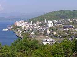 View of Tōyako | |||
| |||
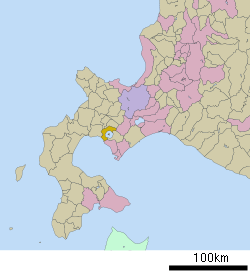 Location of Tōyako in Hokkaido (Iburi Subprefecture) | |||
 Tōyako Location in Japan | |||
| Coordinates: 42°33′N 140°46′E / 42.550°N 140.767°ECoordinates: 42°33′N 140°46′E / 42.550°N 140.767°E | |||
| Country | Japan | ||
| Region | Hokkaido | ||
| Prefecture | Hokkaido (Iburi Subprefecture) | ||
| District | Abuta (Iburi) | ||
| Government | |||
| • Mayor | Yoshio Nagasaki | ||
| Area | |||
| • Total | 180.54 km2 (69.71 sq mi) | ||
| Population (September 30, 2016) | |||
| • Total | 9,231 | ||
| • Density | 51/km2 (130/sq mi) | ||
| Symbols | |||
| • Tree | Cherry blossom, Sorbus commixta | ||
| • Flower | Viola mandshurica, Rhododendron | ||
| Time zone | UTC+9 (JST) | ||
| City hall address |
58 Sakae-chō, Tōyako-chō, Abuta-gun, Hokkaido 049-5692 | ||
| Website | http://www.town.toyako.hokkaido.jp/ | ||

Tōyako (洞爺湖町 Tōyako-chō) is a town in Iburi Subprefecture, Hokkaido, Japan. It was formed on March 23, 2006, through the merger of the town of Abuta and the village of Tōya.
As of 30 September 2016, the town has an estimated population of 9,231, and a population density of 51 persons per km². The total area is 180.54 km².[1]
The name of the town was derived from the nearby Lake Tōya (Tōya-ko).
G8 summit
On April 23, 2007, the town and its surrounding area was announced as the site of the 2008 summer G8 summit. Japan's former Prime Minister Shinzo Abe reportedly chose the area because of its proximity to many famous sightseeing grounds, such as Lake Tōya and Tōyako Onsen.[2]
Famous sights
- Shikotsu-Tōya National Park
- The Windsor Hotel Toya Resort & Spa, the main conference site of 34th G8 summit
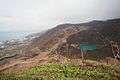 The volcanic crater of Mount Usu, with Tōyako on the left
Notable people from Tōyako
- Mashiro Ayano, singer
References
- ↑ 洞爺湖町へようこそ Archived 2012-02-26 at the Wayback Machine. Town of Tōyako
- ↑ 来夏サミット開催地、洞爺湖地域に決まる Sankei Shinbun
External links
| Wikimedia Commons has media related to Tōyako, Hokkaidō. |
- Official Website (in Japanese)
| ||||||||||
| ||||||||||
| ||||||||||
| ||||||||||
| ||||||||||
| ||||||||||
| ||||||||||
| ||||||||||
| ||||||||||
| ||||||||||
| ||||||||||
| ||||||||||
| ||||||||||
| ||||||||||
This article is issued from
Wikipedia.
The text is licensed under Creative Commons - Attribution - Sharealike.
Additional terms may apply for the media files.