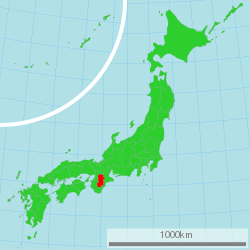
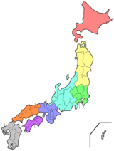
Nara Prefecture
| Nara Prefecture 奈良県 | |||
|---|---|---|---|
| Prefecture | |||
| Japanese transcription(s) | |||
| • Japanese | 奈良県 | ||
| • Rōmaji | Nara-ken | ||
| |||
 | |||
| Country | Japan | ||
| Region | Kansai | ||
| Island | Honshu | ||
| Capital | Nara (city) | ||
| Government | |||
| • Governor | Shōgo Arai | ||
| Area | |||
| • Total | 3,691.09 km2 (1,425.14 sq mi) | ||
| Area rank | 40th | ||
| Population (September 1, 2017) | |||
| • Total | 1,348,930 | ||
| • Rank | 29th | ||
| • Density | 365.46/km2 (946.5/sq mi) | ||
| ISO 3166 code | JP-29 | ||
| Districts | 7 | ||
| Municipalities | 39 | ||
| Flower |
Nara yae zakura (Prunus verecunda cultivar) | ||
| Tree | Sugi (Cryptomeria japonica) | ||
| Bird | Japanese robin (Erithacus akahige) | ||
| Fish |
Goldfish ( Carassius auratus auratus )[1] Ayu (Plecoglossus altivelis altivelis)[1] Amago (Oncorhynchus masou ishikawae)[1] | ||
| Website |
www | ||


Nara Prefecture (奈良県 Nara-ken) is a prefecture in the Kansai region of Japan.[2] The capital is the city of Nara.[3] Nara Prefecture has the distinction of having more UNESCO World Heritage Listings than any other prefecture.[4]
History
Nara Prefecture region is considered one of the oldest regions in Japan, having been in existence for thousands of years. The current form of Nara Prefecture was officially created in 1887 when it became independent of Osaka Prefecture.
Historically, Nara Prefecture was also known as Yamato-no-kuni or Yamato Province.[5]
Up to Nara Period
From the third century to the fourth century, a poorly documented political force existed at the foot of Mount Miwa, east of Nara Basin. It sought unification of most parts in Japan. Since the historical beginning of Japan, Yamato was its political center.
Ancient capitals of Japan were built on the land of Nara, namely Asuka-kyō, Fujiwara-kyō (694–710)[6] and Heijō-kyō (most of 710–784).[7] The capital cities of Fujiwara and Heijō are believed to have been modeled after Chinese capitals at the time, incorporating grid layout patterns. The royal court also established relations with Sui and then Tang dynasty China and sent students to the Middle Kingdom to learn high civilization. By 7th century, Nara accepted the many immigrants including refugees of Baekje who had escaped from war disturbances of the southern part of the Korean Peninsula. The first high civilization with royal patronage of Buddhism flourished in today's Nara city (710–784 AD).
Nara in the Heian period

In 784, Emperor Kanmu decided to relocate the capital to Nagaoka-kyō in Yamashiro Province, followed by another move in 794 to Heian-kyō, marking the start of the Heian period. The temples in Nara remained powerful beyond the move of political capital, thus giving Nara a synonym of "Nanto" (meaning "South Capital") as opposed to Heian-kyō, situated in the north. Close to the end of Heian period, Taira no Shigehira, a son of Taira no Kiyomori, was ordered by his father to depress the power of various parties, mainly Kōfuku-ji and Tōdai-ji, who were backing up an opposition group headed by Prince Mochihito. The movement led to a collision between the Taira and the Nara temples in 1180. This clash eventually led to Kōfuku-ji and Tōdai-ji being set on fire, resulting in vast destruction of architectural heritage.
Medieval Nara
At the rise of the Minamoto to its ruling seat and the opening of Kamakura shogunate, Nara enjoyed the support of Minamoto no Yoritomo toward restoration. Kōfuku-ji, being the "home temple" to the Fujiwara since its foundation, not only regained the power it had before but became a de facto regional chief of Yamato Province. With the reconstruction of Kōfuku-ji and Tōdai-ji, a town was growing again near the two temples.
The Nanboku-chō period, starting in 1336, brought more instability to Nara. As Emperor Go-Daigo chose Yoshino as his base, a power struggle arose in Kōfuku-ji with a group supporting the South and another siding the North court. Likewise, local clans were split into two. Kōfuku-ji recovered its control over the province for a short time at the surrender of the South Court in 1392, while the internal power game of the temple itself opened a way for the local samurai clans to spring up and fight with each other, gradually acquiring their own territories, thus diminishing the influence of Kōfuku-ji overall.
The Sengoku and Edo periods to present

Later, the whole province of Yamato got drawn into the confusion of the Sengoku period. Tōdai-ji was once again set on fire in 1567, when Matsunaga Hisahide, who was later appointed by Oda Nobunaga to the lord of Yamato Province, fought for supremacy against his former master Miyoshi family. Followed by short appointments of Tsutsui Junkei and Toyotomi Hidenaga by Toyotomi Hideyoshi to the lord, the Tokugawa shogunate ultimately ruled the city of Nara directly, and most parts of Yamato province with a few feudal lords allocated at Kōriyama, Takatori and other places. With industry and commerce developing in the 18th century, the economy of the province was incorporated into prosperous Osaka, the commercial capital of Japan at the time.
The economic dependency to Osaka even characterizes today's Nara Prefecture, for many inhabitants commute to Osaka to work or study there.
Geography
City Town Village
Nara Prefecture is part of the Kansai, or Kinki, region of Japan, and is located in the middle of the Kii Peninsula on the western half of Honshu. Nara Prefecture is landlocked. It is bordered to the west by Wakayama Prefecture and Osaka Prefecture; on the north by Kyoto Prefecture and on the east by Mie Prefecture.
Nara Prefecture is 78.5 km from east to west and 103.6 km from north to south.
Most of the prefecture is covered by mountains and forests, leaving an inhabitable area of only 851 km². The ratio of inhabitable area to total area is 23%, ranked 43rd among the 47 prefectures in Japan.[8]
Nara Prefecture is bisected by the Japan Median Tectonic Line (MTL) running through its territory east to west, along the Yoshino River. On the northern side of the MTL is the so-called Inner Zone, where active faults running north to south are still shaping the landscape. The Ikoma Mountains in the northwest form the border with Osaka Prefecture. The Nara Basin, which lies to the east of these mountains, contains the highest concentration of population in Nara Prefecture. Further east are the Kasagi Mountains, which separate the Basin from the Yamato Highlands.
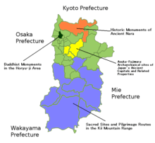
South of the MTL is the Outer Zone, comprising the Kii Mountains, which occupy about 60% of the land area of the prefecture. The Ōmine Range is in the center of the Kii Mountains, running north to south, with steep valleys on both sides. The tallest mountain in Nara Prefecture, and indeed in the Kansai region, is Mount Hakkyō. To the west, separating Nara Prefecture from Wakayama Prefecture, is the Obako Range, with peaks around 1,300 metres. To the east, bordering Mie Prefecture, is the Daikō Range, including Mount Ōdaigahara. This mountainous region is also home to a World Heritage Site, the Sacred Sites and Pilgrimage Routes in the Kii Mountain Range".
About 17% of the total land area of the prefecture is designated as National Park land, comprising the Yoshino-Kumano National Park, Kongō-Ikoma-Kisen, Kōya-Ryūjin, Murō-Akame-Aoyama, and Yamato-Aogaki Quasi-National Parks; and the Tsukigase-Kōnoyama, Yata, and Yoshinogawa-Tsuboro Prefectural Natural Parks.[9]
Climate
In the Nara Basin, the climate has inland characteristics, as represented in the bigger temperature variance within the same day, and the difference of summer and winter temperatures. Winter temperatures average about 3 to 5°C, and 25 – 28°C in the summer with highest reaching close to 35°C. There is not a single year over the last decade (since 1990, up to 2007) with more than 10 days of snowfall recorded by Nara Local Meteorological Observatory.
The climate in the rest of the prefecture are mountainous, and especially in the south, with below −5°C being the extreme minimum in winter. Heavy rainfall is observed in summer. The annual accumulated rainfall ranges as much as 3000 to 5000 mm, which is among the heaviest in Japan.
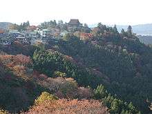
Spring and fall are both temperate and beautiful. The mountainous region of Yoshino has been popular both historically and presently for its beautiful cherry blossoms in the spring. In the fall, the southern mountains are equally beautiful with the changing of the oak trees.

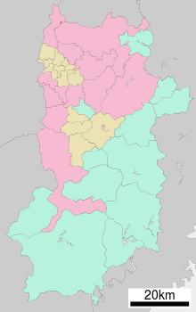
Cities
There are twelve cities in Nara Prefecture:
Towns and villages
There are seven districts in Nara, which are further divided into 15 towns and 12 villages as follows:
Mergers
Demographics
| Population by districts[10] | |||
| District | Area Size (km²) | Population | Density per km² |
| Yamato flat inland plain | 837.27 | 1,282 | 1,531 |
| (Share in %) | 22.7% | 89.7% | |
| Yamato highland | 506.89 | 56 | 110 |
| (Share in %) | 13.7% | 3.9% | |
| Gojō, Yoshino | 2,346.84 | 92 | 39 |
| (Share in %) | 63.6% | 6.4% | |
| Total Prefecture | 3,691.09 | 1,430 | 387 |
| (Share in %) | 100.0% | 100.0% | |
According to the 2005 Census of Japan, Nara Prefecture has a population of 1,421,310, which is a decrease of 1.5%, since the year 2000.[11]
The decline continued in 2006, with another decrease of 4,987 people compared to 2005. This includes a natural decrease from previous year of 288 people (11,404 births minus 11,692 deaths) and a decrease due to net domestic migration of 4,627 people outbound from the prefecture, and a decrease of 72 registered foreigners. Net domestic migration has turned into a continuous outbound trend since 1998. The largest destinations of migration in 2005 were the prefectures of Kyoto, Tokyo, and Hyōgo, with respectively a net of 1,130,982 and 451 people moving over. The largest inbound migration was from Niigata Prefecture, contributing to a net increase of 39 people. 13.7% of its population were reported as under 15, 65.9% between 15 and 64, and 20.4% were 65 or older. Females made up approximately 52.5% of the population.[12]
As of 2004, the average density of the prefecture is 387 people per km². By districts,[13] the so-called Yamato flat inland plain holds as much as about 90% of total population within the approximately 23% size of area in the north-west, including the Nara Basin, representing a density of 1,531 people per km². To the contrast, the combined district Gojō and Yoshino District occupies almost 64% of the land, while only 6% of people lives there, resulting in a density of 39 people km².
Nara prefecture had the highest rate in Japan of people commuting outbound for work, at 30.9% in 2000. A similar tendency is seen in prefectures such as Saitama, Chiba, and Kanagawa, all three of them having over 20% of people commuting for other prefectures.[8]
Politics
- A governor and members of prefectural assembly is elected by citizens in accordance with the Local Autonomy Law.
- As of 2007, there are 44 seats in the Nara Prefectural Assembly, voted through 16 electoral blocks.
- There was a clear tendency seen through the results of Lower House election in 2005, that the younger generation executes its voting right much less compared to the older. Only 48.8% of citizens age 20–29 voted, whereas all older generations (grouped by decades) votes more than its younger, reaching the highest voting rate of 86.3% at ages 60–69. The only exception was the 72.1% voting right executed by citizens of 70 or older. The overall average of the prefecture who voted was yet higher, at 70.3%, than that of nationwide average, 67.5%.[14]
Economy
The 2004 total gross prefecture product (GPP) for Nara was ¥3.8 trillion, an 0.1% growth over previous year. The per capita income was ¥2.6 million, which is a 1.3% decrease from previous year. The 2004 total gross prefecture product (GPP) for Nara was ¥3.8 trillion, an 0.1% growth over previous year. Manufacturing has the biggest share in the GPP of Nara with 20.2% of share, followed by services (19.1%) and real estates (16.3%). The share of agriculture including forestry and fishery was a mere 1.0%, only above mining, which is quasi-inexistent in Nara.[15]
- Tourism is treated by the prefectural government as one of the most important features of Nara, because of its natural beauty and historical significance.
- Nara is famed for its Kaki persimmon. Strawberry and tea are some other popular products of the prefecture, while rice and vegetables, including spinach, tomato, eggplants, and others are the dominant in terms of amount of production.
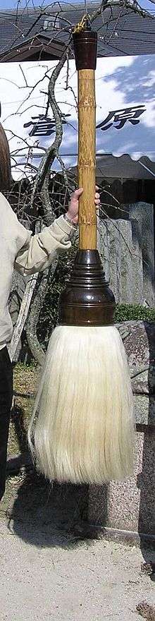
- Nara is a center for the production of instruments used in conducting traditional Japanese artforms. Brush and ink (sumi) are the best known products from Nara for calligraphy. Wooden or bamboo instruments, especially from Takayama area (in Ikoma city) are famous products for tea ceremony.
- Goldfish from Yamatokōriyama in Nara have been a traditional aquacultural product since the 18th century.
- Due to its rich history, Nara is also the location of many archeological digs, with many famous ones being located in the village of Asuka.
Culture
The culture of Nara is tied to the Kansai region in which it is located. However, like each of the other prefectures of Kansai, Nara has unique aspects to its culture, parts of which stem from its long history dating back to the Nara period.
Dialect
There are large differences in dialect between the north/central region of the prefecture, where Nara city is located, and the Okunoya district in the south. The north/central dialect is close to Osaka's dialect, whilst Okunoya's dialect favours a Tokyo-style accent. The lengthening of vowels sounds in the Okunoya dialect is not seen in other dialects of the Kinki region, making it a special feature.
Food culture
Foods particular to Nara Prefecture include:
- Narazuke, a method of pickling vegetables
- Miwa sōmen, a type of wheat noodle
- Chagayu, a rice porridge made with green tea
- Kakinoha zushi, sushi wrapped in persimmon leaves
- Meharizushi, rice balls wrapped in pickled takana leaves
Traditional arts
The following are recognized by the Minister of Economy, Trade and Industry as being traditional arts of Nara:[16][17]
- Takayama Tea Whisk (Bamboo item category, recognized in 1975)
- Nara Calligraphy Brush (Stationery category, recognized in 1977)
Museums
Education
Universities
- Nara Women's University
- Nara Medical University
- Nara University of Education
- Nara University
- Nara Prefectural University
- Nara Sangyo University (Nara Industrial University)
- Nara Institute of Science and Technology
- Kio University
- Tezukayama University
- Tenri University
Hakuho college
Sports
The sports teams listed below are based in Nara.
Basketball
Tourism
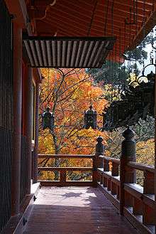
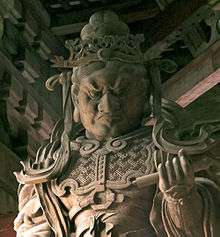
Many jinja (Shinto shrines), Buddhist temples, and kofun exist in Nara Prefecture, making it is a centre for tourism. Moreover, many world heritage sites, such as the temple Tōdai-ji and Kasuga Shrine, exist in the capital city of Nara.
World Heritage sites
|
Buddhist Monuments in the Hōryū-ji Area
|
Historic Monuments of Ancient Nara
|
|
Sacred Sites and Pilgrimage Routes in the Kii Mountain Range
|
|
Buddhist temples
|
Shinto shrines
|
|
Kofun and heritage
|
Hot springs
|
|
|
Mountains
|
Other attractions
| ||||||||||||||||||
Transportation
Railroad
Bus
from Nara and Tenri
from Yamato Yagi and Gose
Road
Expressways and toll roads
- Nishi-Meihan Expressway
- Meihan Road
- Keinawa Expressway
- Second Hanna(Osaka-Nara) Road
- South Hanna Road
National highways
Notes
- 1 2 3 "金魚・アユ・アマゴを「奈良県のさかな」に – MSN産経west" [Goldfish, Ayu, and Amago elected "Fish of Nara prefecture".]. Sankei Shimbun (in Japanese). June 27, 2012. Archived from the original on June 27, 2012. Retrieved June 27, 2012.
- ↑ Nussbaum, Louis-Frédéric. (2005). "Nara-ken" in Japan Encyclopedia, p. 699, p. 699, at Google Books; "Kansai" at p. 477, p. 477, at Google Books.
- ↑ Nussbaum, "Nara" at p. 698, p. 698, at Google Books.
- ↑ "Nara". GoJapanGo. Retrieved June 19, 2012.
- ↑ Nussbaum, "Yamato" at p. 1046, p. 1046, at Google Books.
- ↑ 奈良文化財研究所 (2014-11-08). "藤原宮大極殿院の調査(飛鳥藤原第182次)". Comprehensive Database of Archaeological Site Reports in Japan. Retrieved 2016-09-02.
- ↑ 奈良市埋蔵文化財調査センター (2009-11-02). "出土品に見る奈良のやきものと暮らし". Comprehensive Database of Archaeological Site Reports in Japan. Retrieved 2016-09-02.
- 1 2 "奈良県統計情報 "100の指標" ("100 Indices of Nara" by Nara Statistics Division, Nara Prefecture)" (in Japanese). Retrieved 2007-03-17.
- ↑ "General overview of area figures for Natural Parks by prefecture" (PDF). Ministry of the Environment. 1 April 2012. Retrieved 29 May 2014.
- ↑ Whitepaper on Ecology (Japanese). Prefecture of Nara. Retrieved April 10, 2007.
- ↑ "Population Census 2005" (in Japanese). Archived from the original on April 15, 2008. Retrieved 2007-04-10. (Including official amendment of March 5, 2007)
- ↑ "Population Statistics of Nara Prefecture 2006" (in Japanese). Archived from the original on January 18, 2008. Retrieved 2007-04-10.
- ↑ Defined by Nara Prefecture for the convenience of statistical analysis. See "Population of each district" for 2005 figures.
- ↑ "tōhyō ritsu no sui'i (投票率の推移 Evolution in voting rate, Nara Prefecture" (in Japanese). Archived from the original on June 12, 2008. Retrieved 2007-04-10.
- ↑ "奈良県民経済計算 (Nara kenmin keizai keisan Nara Prefectural Economy)". Nara Prefecture. April 9, 2002. Archived from the original on March 14, 2007. Retrieved 2007-03-28. English page with much less details are available here.
- ↑ "奈良県の産地紹介" [Introduction to Nara Prefecture's Items] (in Japanese). METI. 2004. Retrieved 8 July 2015.
- ↑ "奈良県の産地" [Nara Prefecture's Items] (PDF). METI. Retrieved 8 July 2015.
References
- Nussbaum, Louis-Frédéric and Käthe Roth. (2005). Japan encyclopedia. Cambridge: Harvard University Press. ISBN 978-0-674-01753-5; OCLC 58053128
External links
| Wikimedia Commons has media related to Nara prefecture. |
- Official Nara Prefecture homepage
- Nara Prefecture All Rights Reserved
- okuyamato.pref.nara
- Buddhist Monuments in the Horyu-ji Area (UNESCO)
- Historic Monuments of Ancient Nara (UNESCO)
- Sacred Sites and Pilgrimage Routes in the Kii Mountain Range (UNESCO)
- Map of Nara City
- Photos of Nara's temples & shrines
- Nara Tourist Information Center
- Commemorative Events of the 1300th Anniversary of Nara Heijo-kyo Capital
- Comprehensive Database of Archaeological Site Reports in Japan, Nara National Research Institute for Cultural Properties
| Core city | ||
|---|---|---|
| Cities | ||
| Districts | ||
Coordinates: 34°34′N 135°46′E / 34.567°N 135.767°E
| Authority control |
|---|