Nayoro, Hokkaido
| Nayoro 名寄市 | |||
|---|---|---|---|
| City | |||
| |||
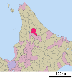 Location of Nayoro in Hokkaido (Kamikawa Subprefecture) | |||
 Nayoro Location in Japan | |||
| Coordinates: 44°21′21″N 142°27′48″E / 44.35583°N 142.46333°ECoordinates: 44°21′21″N 142°27′48″E / 44.35583°N 142.46333°E | |||
| Country | Japan | ||
| Region | Hokkaido | ||
| Prefecture | Hokkaido (Kamikawa Subprefecture) | ||
| Government | |||
| • Mayor | Takeshi Kato | ||
| Area | |||
| • Total | 535.23 km2 (206.65 sq mi) | ||
| Population (September 2016) | |||
| • Total | 28,373 | ||
| • Density | 53/km2 (140/sq mi) | ||
| Symbols | |||
| • Tree | Japanese white birch | ||
| • Flower | Ōbana enreisō (Trillium kamtschaticum) | ||
| • Bird | Great spotted woodpecker | ||
| Time zone | UTC+9 (JST) | ||
| City hall address |
1-1 Ōdōri Minami, Nayoro-shi, Hokkaido 096-8686 | ||
| Website |
www | ||


Nayoro (名寄市 Nayoro-shi, Ainu: Nay Oro meaning "in the middle of the valley") is a city in Kamikawa Subprefecture, Hokkaido, Japan.
As of September 2016, the city has an estimated population of 28,373 and a population density of 53 persons per km2 (140 persons per sq. mi.). The total area is 535.23 km2 (206.65 sq mi).
On March 27, 2006, the town of Fūren was merged into Nayoro.
History
- 1909: Kaminayoro village was founded.
- 1915: Kaminayoro village became Nayoro town.
- 1920: Chiebun village split off from Shimonayoro village.
- 1924: Shimokawa village was separated from Nayoro town.
- 1954: Nayoro town and Chiebun village was merged to form Nayoro town.
- 1956: Nayoro town became Nayoro city.
- 2006: Nayoro city and Fūren town was merged to form Nayoro city.
Education
Universities
Junior colleges
High schools
- Hokkaido Nayoro High School
- Hokkaido Nayoro Industry High School
Transportation
Rail
Nayoro Main Line and Shimmei Line used to run from Nayoro Station. There was Chitō Station between Nisshin Station and Hokusei Station.
- Sōya Main Line : Fūren - Higashi-Fūren - Nayoro - Nisshin - Hokusei - Chiebun - Chihoku
Road
Nayoro is linked with National Route 40 linking Wakkanai and southern Hokkaido as well as the Hokkaidō Expressway linking with the island capital of Sapporo. Nayoro is bypassed to the west with the Nayoro Bypass (Route 40) serving two interchanges.
Climate
Nayoro has a wet and snowy warm-summer humid continental climate (Köppen climate classification Dfb). The climate retains warm and sometimes hot summers with very cold winters by Japanese standards, coupled with heavy sea-effect snowfall.
| Climate data for Nayoro (1981–2010) | |||||||||||||
|---|---|---|---|---|---|---|---|---|---|---|---|---|---|
| Month | Jan | Feb | Mar | Apr | May | Jun | Jul | Aug | Sep | Oct | Nov | Dec | Year |
| Average high °C (°F) | −4.7 (23.5) |
−3.3 (26.1) |
1.4 (34.5) |
9.2 (48.6) |
17.2 (63) |
22.2 (72) |
25.5 (77.9) |
25.9 (78.6) |
21.1 (70) |
14.1 (57.4) |
5.1 (41.2) |
−1.8 (28.8) |
11 (51.8) |
| Daily mean °C (°F) | −9.4 (15.1) |
−9 (16) |
−3.6 (25.5) |
3.8 (38.8) |
10.4 (50.7) |
15.4 (59.7) |
19.2 (66.6) |
20.1 (68.2) |
14.8 (58.6) |
8.1 (46.6) |
1.2 (34.2) |
−5.4 (22.3) |
5.5 (41.9) |
| Average low °C (°F) | −15.8 (3.6) |
−16.2 (2.8) |
−9.8 (14.4) |
−1.7 (28.9) |
3.6 (38.5) |
9.2 (48.6) |
13.9 (57) |
15.2 (59.4) |
9.4 (48.9) |
2.9 (37.2) |
−2.7 (27.1) |
−10.3 (13.5) |
−0.2 (31.7) |
| Average precipitation mm (inches) | 54.6 (2.15) |
41.2 (1.622) |
45.3 (1.783) |
45.7 (1.799) |
57.5 (2.264) |
58.6 (2.307) |
112.9 (4.445) |
121.9 (4.799) |
131.6 (5.181) |
117.0 (4.606) |
112.1 (4.413) |
79.6 (3.134) |
978 (38.503) |
| Average snowfall cm (inches) | 208 (81.9) |
162 (63.8) |
140 (55.1) |
36 (14.2) |
0 (0) |
0 (0) |
0 (0) |
0 (0) |
0 (0) |
3 (1.2) |
112 (44.1) |
229 (90.2) |
890 (350.5) |
| Mean monthly sunshine hours | 64.0 | 90.5 | 133.6 | 157.5 | 186.5 | 168.3 | 145.4 | 141.9 | 139.1 | 109.9 | 52.1 | 42.4 | 1,431.2 |
| Source: Japan Meteorological Agency | |||||||||||||
Sister cities and partner cities
International


Within Japan
References
External links
| Wikimedia Commons has media related to Nayoro, Hokkaido. |
- Official Website (in Japanese)
| ||||||||||
| ||||||||||
| ||||||||||
| ||||||||||
| ||||||||||
| ||||||||||
| ||||||||||
| ||||||||||
| ||||||||||
| ||||||||||
| ||||||||||
| ||||||||||
| ||||||||||
| ||||||||||
| Authority control |
|---|