Kikonai, Hokkaido
| Kikunai 木古内町 | |||
|---|---|---|---|
| Town | |||
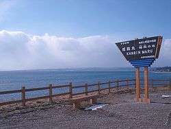 Memorial Tablet for the Kanrin Maru Sinking at Saraki Point (February 2009) | |||
| |||
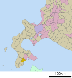 The location of Kikonai in Oshima Subprefecture. | |||
 Kikunai Location of Kikonai in Japan | |||
| Coordinates: 41°41′N 140°26′E / 41.683°N 140.433°ECoordinates: 41°41′N 140°26′E / 41.683°N 140.433°E | |||
| Country | Japan | ||
| Prefecture | Hokkaido | ||
| Subprefecture | Oshima Subprefecture | ||
| District | Kamiiso | ||
| Government | |||
| • Mayor | Isao Ōmori | ||
| Area | |||
| • Total | 221.88 km2 (85.67 sq mi) | ||
| Population (2016-09-30) | |||
| • Total | 4,448 | ||
| • Density | 20/km2 (52/sq mi) | ||
| Post code | 049-0422 | ||
| Area code(s) | 01392 | ||
| Official Tree | Cryptomeria | ||
| Official Flower | Rhododendron | ||
| Government Office Address | 218 Banchi, Aza Hon-chō, Kikonai-chō, Kamiiso-gun, Hokkaidō 049-0422 | ||
| Government Office Telephone | 01392-2-3131 | ||
| Website |
www | ||


Kikonai (木古内町 Kikonai-chō) is a town located in Oshima Subprefecture, Hokkaido, Japan.
As of September 2016, the town has an estimated population of 4,448, and a density of 20 persons per km². The total area is 221.88 km².
Geography
Kikonai is located on the southwest of the Oshima Peninsula and faces Tsugaru Strait.
Neighboring towns
History
- 1902: Kikonai village was founded.[1]
- 1942: Kikonai village became Kikonai town.
- 2012: Hokkaido Kikonai High School was closed.
Transportation
Kikonai's station, Kikonai Station, is located at the north end of the Seikan Tunnel, which connects the islands of Hokkaido and Honshū. The town government is actively promoting the development of the Hokkaidō Shinkansen and proposes offering intermodal service on the line.
Matsumae Line used to run from Kikonai but it was abolished in 1988. The section of Esashi Line from Kikonai to Esashi was also abolished in May 2014.
- Esashi Line: Kamaya - Izumisawa - Satsukari - Kikonai ( - Oshima-Tsuruoka - Yoshibori)
- Kaikyō Line: Kikonai
Sister city
- Tsuruoka, Yamagata (since 1989)[2]
References
External links
![]()
- Official Website (in Japanese)
| ||||||||||
| ||||||||||
| ||||||||||
| ||||||||||
| ||||||||||
| ||||||||||
| ||||||||||
| ||||||||||
| ||||||||||
| ||||||||||
| ||||||||||
| ||||||||||
| ||||||||||
| ||||||||||