Nakatonbetsu, Hokkaido
| Nakatonbetsu 中頓別町 | |||
|---|---|---|---|
| Town | |||
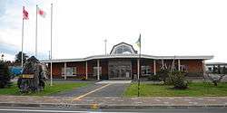 Nakatonbetsu town hall | |||
| |||
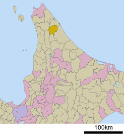 Location of Nakatonbetsu in Hokkaido (Sōya Subprefecture) | |||
 Nakatonbetsu Location in Japan | |||
| Coordinates: 44°58′N 142°17′E / 44.967°N 142.283°ECoordinates: 44°58′N 142°17′E / 44.967°N 142.283°E | |||
| Country | Japan | ||
| Region | Hokkaido | ||
| Prefecture | Hokkaido (Sōya Subprefecture) | ||
| District | Esashi | ||
| Area | |||
| • Total | 398.55 km2 (153.88 sq mi) | ||
| Population (September 30, 2016) | |||
| • Total | 1,776 | ||
| • Density | 4.5/km2 (12/sq mi) | ||
| Time zone | UTC+9 (JST) | ||
| Website |
www | ||

Nakatonbetsu (中頓別町 Nakatonbetsu-chō) is a town located in Sōya Subprefecture, Hokkaido, Japan.
As of September 2016, the town has an estimated population of 1,776 and a density of 4.5 persons per km². The total area is 398.55 square kilometres (153.88 sq mi).
External links

- Official Website (in Japanese)
| ||||||||||
| ||||||||||
| ||||||||||
| ||||||||||
| ||||||||||
| ||||||||||
| ||||||||||
| ||||||||||
| ||||||||||
| ||||||||||
| ||||||||||
| ||||||||||
| ||||||||||
| ||||||||||
This article is issued from
Wikipedia.
The text is licensed under Creative Commons - Attribution - Sharealike.
Additional terms may apply for the media files.