Sarabetsu, Hokkaido
| Sarabetsu 更別村 | |||
|---|---|---|---|
| Village | |||
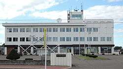 Sarabetsu Village hall | |||
| |||
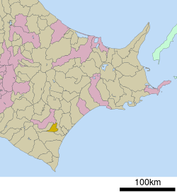 Location of Sarabetsu in Hokkaido (Tokachi Subprefecture) | |||
 Sarabetsu Location in Japan | |||
| Coordinates: 42°39′N 143°11′E / 42.650°N 143.183°ECoordinates: 42°39′N 143°11′E / 42.650°N 143.183°E | |||
| Country | Japan | ||
| Region | Hokkaido | ||
| Prefecture | Hokkaido (Tokachi Subprefecture) | ||
| District | Kasai | ||
| Area | |||
| • Total | 176.45 km2 (68.13 sq mi) | ||
| Population (September 30, 2016) | |||
| • Total | 3,275 | ||
| • Density | 19/km2 (48/sq mi) | ||
| Time zone | UTC+9 (JST) | ||
| Website |
www | ||


Sarabetsu (更別村 Sarabetsu-mura) is a village located in Tokachi Subprefecture, Hokkaido, Japan.
As of September 2016, the village has an estimated population of 3,275. The total area is 176.45 km².
External links

- Official Website (in Japanese)
| ||||||||||
| ||||||||||
| ||||||||||
| ||||||||||
| ||||||||||
| ||||||||||
| ||||||||||
| ||||||||||
| ||||||||||
| ||||||||||
| ||||||||||
| ||||||||||
| ||||||||||
| ||||||||||
This article is issued from
Wikipedia.
The text is licensed under Creative Commons - Attribution - Sharealike.
Additional terms may apply for the media files.