This article is about the town in Sōya Subprefecture, Hokkaido. For the town in Hiyama Subprefecture, Hokkaido, see
Esashi, Hokkaido (Hiyama).
Esashi (枝幸町, Esashi-chō) is a town in Sōya Subprefecture, Hokkaido, Japan.
As of September 2016, its estimated population is 8,578 and its area is 1,115.67 square kilometres (430.76 square miles).
The name comes from the Ainu word Esaushi, meaning "cape" (in the geographic sense).[1][2]
Geography
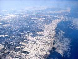
Esashi is located at the southeast tip of Sōya Subprefectures. The town faces the Sea of Okhotsk to the east, the town of Utanobori to the west, the town of Bifuka to the southwest, Ōmu to the south, and Hamatonbetsu to the north. The southern border of the city is marked by the Toinai River, and the north is marked by Cape Kamui.[3]
The residential districts of Esashi are on a long, narrow strip of the coast ranging from north to south; 67.08% of the town is forested, 14.7% is unused plain land, and only .44% of the town consists of residential land.[3]
History
Esashi District was established in 1869 in Kitami Province (1868-1882), a short-lived province in the north of Hokkaido. The district was historically under the control of the Kaga Domain on Honshu; this control ended in 1870.[4][5][6]
It consisted of four villages: Esashi, Tonbetsu, Utanobori and Rebun Village (礼文村, apparently unrelated to the town of Rebun on Rebun Island) In September, 1891 a town hall for the 3 villages set up.
- April, 1909 :Esashi Village becomes a second-class municipality
- April, 1916 :Tonbetsu Village (now Hamatonbetsu Town) split off
- April, 1923 :Esashi becomes a first-class municipality
- September, 1939: Utanobori Village (now town) split off
- October, 1947: Esashi was elevated to town status.
- On March 20, 2006, the town of Utanobori was merged into Esashi for the second time.[1][3]
References
- 1 2 "枝幸(町)" [Esashi]. Nihon Daihyakka Zensho (Nipponika) (in Japanese). Tokyo: Shogakukan. 2013. OCLC 153301537. Archived from the original on 2007-08-25. Retrieved 2013-09-06.
- ↑ 枝幸町の給与・定員管理等について (PDF) (in Japanese). Esashi, Hokkaido: Town of Esashi. 2011. Retrieved 2013-09-06.
- 1 2 3 "枝幸町" [Esashi]. Nihon Rekishi Chimei Taikei (in Japanese). Tokyo: Shogakukan. 2013. OCLC 173191044. Archived from the original on 2007-08-25. Retrieved 2013-09-09.
- ↑ "北見国" [Kitami Province]. Kokushi Daijiten (in Japanese). Tokyo: Shogakukan. 2013. OCLC 683276033. Archived from the original on 2007-08-25. Retrieved 2013-09-09.
- ↑ "枝幸" [Esashi]. Nihon Kokugo Daijiten (in Japanese). Tokyo: Shogakukan. 2013. OCLC 56431036. Archived from the original on 2007-08-25. Retrieved 2013-09-10.
- ↑ "枝幸郡" [Esashi District]. Kokushi Daijiten (in Japanese). Tokyo: Shogakukan. 2013. OCLC 683276033. Archived from the original on 2007-08-25. Retrieved 2013-09-09.
External links
Authority control  | |
|---|
_in_Hokkaido_Prefecture_Ja.svg.png)