Oshamambe, Hokkaido
| Oshamambe 長万部町 | |||
|---|---|---|---|
| Town | |||
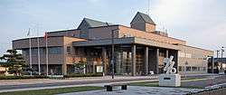 Oshamanbe Town Hall | |||
| |||
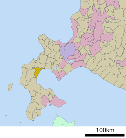 Location of Oshamambe in Hokkaido (Oshima Subprefecture) | |||
 Oshamambe Location in Japan | |||
| Coordinates: 42°30′29″N 140°22′23″E / 42.50806°N 140.37306°ECoordinates: 42°30′29″N 140°22′23″E / 42.50806°N 140.37306°E | |||
| Country | Japan | ||
| Region | Hokkaido | ||
| Prefecture | Hokkaido (Oshima Subprefecture) | ||
| District | Yamakoshi | ||
| Government | |||
| • Mayor | Masashi Kihata | ||
| Area | |||
| • Total | 310.75 km2 (119.98 sq mi) | ||
| Population (30 September 2016) | |||
| • Total | 5,694 | ||
| • Density | 18/km2 (47/sq mi) | ||
| Symbols | |||
| • Tree | Pinus thunbergii | ||
| • Flower | Iris sanguinea | ||
| Time zone | UTC+9 (JST) | ||
| City hall address |
453-1 Oshamambe, Oshamambe, Yamakoshi District, Hokkaido 049-3592 | ||
| Website |
www | ||


Oshamambe (長万部町 Oshamambe-chō) is a town located in Oshima Subprefecture, Hokkaido, Japan.
As of 30 October 2016, the town has an estimated population of 5,694. The total land area is 310.75 km².
Geography
Oshamambe faces Uchiura Bay, which is a bay of the Pacific Ocean.
Neighboring municipalities
- Oshima Subprefecture
- Hiyama Subprefecture
- Shiribeshi Subprefecture
- Iburi Subprefecture
History
- 1864: The village of Oshamambe was founded.[1]
- 1906: Oshamambe became a Second Class Village.
- 1923: Oshamambe became a First Class Village.
- 1943: Oshamambe village became Oshamambe town.
Education
University
- Tokyo University of Science, Oshamambe Campus
High school
- Hokkaido Oshamambe High School
Junior high school
- Oshamambe Junior High School
Elementary schools
- Oshamambe Elementary School
- Shizukari Elementary School
Transportation
Setana Line ran from Kunnui Station. There used to be Asahihama station between Oshamambe Station and Shizukari Station.
- Hakodate Main Line: Kita-Toyotsu - Kunnui - Nakanosawa - Oshamambe - Futamata - Warabitai
- Muroran Main Line: Oshamambe - Shizukari
- Hokkaido Expressway: Shizukari PA - Oshamambe IC - Kunnui IC
- Route 5
Plans are in place to build a station at Oshamambe and construction is underway on the Hokkaido Shinkansen line. The section between Hakodate and Sapporo should be completed by 2030.
References
External links

- Official Website (in Japanese)
| ||||||||||
| ||||||||||
| ||||||||||
| ||||||||||
| ||||||||||
| ||||||||||
| ||||||||||
| ||||||||||
| ||||||||||
| ||||||||||
| ||||||||||
| ||||||||||
| ||||||||||
| ||||||||||
This article is issued from
Wikipedia.
The text is licensed under Creative Commons - Attribution - Sharealike.
Additional terms may apply for the media files.