Ashibetsu, Hokkaido
| Ashibetsu 芦別市 | |||
|---|---|---|---|
| City | |||
| |||
 Location of Ashibetsu in Hokkaido (Sorachi Subprefecture) | |||
 Ashibetsu Location in Japan | |||
| Coordinates: 43°31′N 142°11′E / 43.517°N 142.183°ECoordinates: 43°31′N 142°11′E / 43.517°N 142.183°E | |||
| Country | Japan | ||
| Region | Hokkaido | ||
| Prefecture | Hokkaido (Sorachi Subprefecture) | ||
| Government | |||
| • Mayor | Hiromu konno | ||
| Area | |||
| • Total | 865.02 km2 (333.99 sq mi) | ||
| Population (September 30, 2016) | |||
| • Total | 14,260 | ||
| • Density | 16/km2 (43/sq mi) | ||
| Symbols | |||
| • Tree | Mizunara (Quercus crispula) | ||
| • Flower | Lily | ||
| • Bird | Great tit | ||
| Time zone | UTC+9 (JST) | ||
| City hall address |
1-3 Kita-ichijō Higashi, Ashibetsu-shi, Hokkaidō 075-8711 | ||
| Website |
www | ||


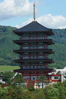
Five-storied pagoda in Ashibetu
Ashibetsu (芦別市 Ashibetsu-shi) is a city located in Sorachi Subprefecture, Hokkaido, Japan.
As of September 2016, the city had an estimated population of 14,260 and a density of 16 persons per km2. The total area is 865.02 km2.
History
Ashibetsu was once a prosperous coal mining city, its population exceeding 70,000 at its peak, but its population has fallen since the closing of the coal mines.[1]
- 1893 - Satō Denjirō (originally from Yamagata Prefecture) founds Ashibetsu.
- 1897 - Nae Village (now Sunagawa City) and part of Takikawa Village (now City) split off to form Utashinai Village.
- 1900 - Ashibetsu Village split off of Utashinai Village.
- 1906 - Ashibetsu becomes a Second Class Municipality.
- 1917 - Kuhara Mining Industry Yuya Ashibetu Coal Mine opened.
- 1923 - First Class Municipality.
- 1924 - Mitsubishi Mining Industry Ashibetsu Coal Mine opened.
- 1935 - Meiji Mining Industry Meiji-Kamiashibetsu Coal Mine opened.
- 1938 - Ashibetsu-Takane Colliery Takane Mining Station opened.
- 1941 - Ashibetsu Village becomes Ashibetsu Town.
- 1943 - Mitsui-Ashibetsu Mining Industry Mitsui-Ashibetsu Coal Mine opened.
- 1953 - Ashibetsu Town becomes Ashibetsu City.
- 1963 - Meiji Mining Industry Meiji-Kamiashibetsu Coal Mine closed.
- 1964 - Mitsubishi Mining Industry Ashibetsu Coal Mine closed.
- 1967 - Ashibetsu-Takane Colliery Takane Mining Station closed.
- 1969 - Yuya Mining Industry Yuya Ashibetu Coal Mine closed.
- 1992 - Mitsui-Ashibetsu Mining Industry Mitsui-Ashibetsu Coal Mine closed.
- 1991 - Canadian World Park opened.
- 1997 - Canadian World business failure (to become a municipal park).
Geography
Ashibetsu is in the northern part of Yūbari Mountains. Mount Ashibetsu is south of the city.
Name
There are two theories about the origin of "Ashibetsu". In both theories the name means Ashibetsu River, which flows through the city.[1]
- "as pet", the river that flows in a shrub
- "hasi pet", the standing river
Locations of interest
- The Hokkaido Kannon is the third-tallest statue in Japan and is the tenth-tallest in the world. It was considered the tallest statue in the world when it opened in 1989 at 88 metres (289 ft), holding the world record until 1991.[2]
Neighbourhoods
- Asahichō (旭町)
- Asahimachi Yuya (旭町油谷)
- Ashibetsu (芦別)
- Fukuzumichō (福住町)
- Higashiraijōchō (東頼城町)
- Honchō (本町)
- Horonai (幌内)
- Izumi (泉)
- Kamiashibetsuchō (上芦別町)
- Kawagishi (川岸)
- Kita 1 Jōhigashi (北1条東)
- 1 chōme (1丁目)
- 2 chōme (2丁目)
- Kita 2 Jōhigashi (北2条東)
- 1 chōme (1丁目)
- 2 chōme (2丁目)
- Kita 3 Jōhigashi (北3条東)
- 1 chōme (1丁目)
- 2 chōme (2丁目)
- Kita 4 Jōhigashi (北4条東)
- Kita 5 Jōhigashi (北5条東)
- 1 chōme (1丁目)
- 2 chōme (2丁目)
- Kita 6 Jōhigashi (北6条東)
- Kita 1 Jōnishi (北1条西)
- 1 chōme (1丁目)
- 2 chōme (2丁目)
- Kita 2 Jōnishi (北2条西)
- 1 chōme (1丁目)
- 2 chōme (2丁目)
- Kita 3 Jōnishi (北3条西)
- 1 chōme (1丁目)
- 2 chōme (2丁目)
- 3 chōme (3丁目)
- Kita 4 Jōnishi (北4条西)
- 1 chōme (1丁目)
- 2 chōme (2丁目)
- 3 chōme (3丁目)
- 4 chōme (4丁目)
- Kita 5 Jōnishi (北5条西)
- 1 chōme (1丁目)
- 2 chōme (2丁目)
- 3 chōme (3丁目)
- 4 chōme (4丁目)
- 5 chōme (5丁目)
- Kita 6 Jōnishi (北6条西)
- 1 chōme (1丁目)
- 2 chōme (2丁目)
- 3 chōme (3丁目)
- 4 chōme (4丁目)
- 5 chōme (5丁目)
- Kita 7 Jōnishi (北7条西)
- 1 chōme (1丁目)
- 2 chōme (2丁目)
- 3 chōme (3丁目)
- 4 chōme (4丁目)
- 5 chōme (5丁目)
- 6 chōme (6丁目)
- Koganechō (黄金町)
- Minami 1 Jōhigashi (南1条東)
- 1 chōme (1丁目)
- 2 chōme (2丁目)
- Minami 2 Jōhigashi (南2条東)
- 1 chōme (1丁目)
- 2 chōme (2丁目)
- 3 chōme (3丁目)
- Minami 3 Jōhigashi (南3条東)
- 1 chōme (1丁目)
- 2 chōme (2丁目)
- 3 chōme (3丁目)
- Minami 1 Jōnishi (南1条西)
- Nakanookachō (中の丘町)
- Nishiashibetsuchō (西芦別町)
- Nokananchō (野花南町)
- Raijōchō (頼城町)
- Rokusenchō (緑泉町)
- Shinjōchō (新城町)
- Takanechō (高根町)
- Tokiwa (常磐)
- Tokiwachō (常磐町)
- Toyooka (豊岡)
Education
University
College
- Kitanippon Automobile Technical College
High schools
Public
- Hokkaido Ashibetsu High School
Private
- Seisa Kokusai High School
Transportation
Sister city
References
External links
![]()
- Official Website (in Japanese)
| ||||||||||
| ||||||||||
| ||||||||||
| ||||||||||
| ||||||||||
| ||||||||||
| ||||||||||
| ||||||||||
| ||||||||||
| ||||||||||
| ||||||||||
| ||||||||||
| ||||||||||
| ||||||||||
| Authority control |
|---|
This article is issued from
Wikipedia.
The text is licensed under Creative Commons - Attribution - Sharealike.
Additional terms may apply for the media files.