Sōya Subprefecture
宗谷総合振興局 |
|---|
|
Sōya-sōgō-shinkō-kyoku |
 |
| Prefecture |
Hokkaido |
|---|
| Capital |
Wakkanai |
|---|
| Area |
|---|
| • Total |
4,050.76 km2 (1,564.01 sq mi) |
|---|
| Population (March 2009) |
|---|
| • Total |
75,665 |
|---|
| • Density |
19/km2 (48/sq mi) |
|---|
| Website |
souya.pref.hokkaido.lg.jp |
|---|
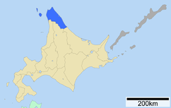
Sōya Subprefecture (宗谷総合振興局, Sōya-sōgō-shinkō-kyoku) is a subprefecture of Hokkaido Prefecture, Japan. Its population is estimated to be 77,500 as of July 31, 2004 and its area is 4,050.84 square kilometres (1,564.04 sq mi). It is the northernmost subprefecture of Japan.
Wakkanai Airport is located in Wakkanai. Rishiri Airport is located in Rishirifuji, Rishiri District.
Geography

Sōya Subprefecture (without Horonobe)
Towns and villages by district
History
- 1897: Sōya Subprefecture established; Sōya, Esashi, Rishiri, Rebun Districts placed under its jurisdiction
- 1948: Toyotomi village (now town), Teshio District transferred from Rumoi Subprefecture
- 2010: Horonobe town, Teshio District transferred from Rumoi Subprefecture