Rankoshi, Hokkaido
| Rankoshi 蘭越町 | |||
|---|---|---|---|
| Town | |||
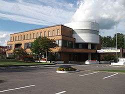 Rankoshi Town Office | |||
| |||
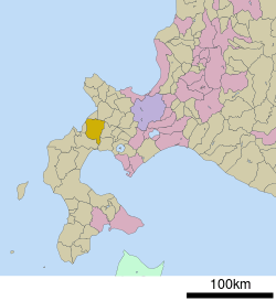 Location of Rankoshi in Hokkaido (Shiribeshi Subprefecture) | |||
 Rankoshi Location in Japan | |||
| Coordinates: 42°49′N 140°32′E / 42.817°N 140.533°ECoordinates: 42°49′N 140°32′E / 42.817°N 140.533°E | |||
| Country | Japan | ||
| Region | Hokkaido | ||
| Prefecture | Hokkaido (Shiribeshi Subprefecture) | ||
| District | Isoya | ||
| Government | |||
| • Mayor | Tomeo Miyauchi | ||
| Area | |||
| • Total | 449.68 km2 (173.62 sq mi) | ||
| Population (September 30, 2016) | |||
| • Total | 4,893 | ||
| • Density | 11/km2 (28/sq mi) | ||
| Symbols | |||
| • Tree | Magnolia kobus | ||
| • Flower | Magnolia kobus | ||
| Time zone | UTC+9 (JST) | ||
| City hall address |
258-5 Rankoshicho, Rankoshi, Isoya-gun, Hokkaido 048-1392 | ||
| Website |
www | ||

Rankoshi (蘭越町 Rankoshi-chō) is a town located in Shiribeshi Subprefecture, Hokkaido, Japan.
As of September 2016, the town has an estimated population of 4,893, and a density of 11 persons per km². The total area is 449.68 km².
Geography
Shiribetsu River flows through Rankoshi to the Sea of Japan. The town is surrounded by Niseko Volcanic Group, which belongs to Niseko-Shakotan-Otaru Kaigan Quasi-National Park.
The name is derived from Ainu word "Ranko-usi", meaning "Place with many Katsura trees".[1]
- Mountains: Mount Raiden, Mount Mekunnai, Mount Chisenupuri, Mount Nitonupuri
Neighboring towns
- Shiribeshi Subprefecture
- Iburi Subprefecture
History
- 1909: Minamishiribeshi became a Second Class Village.[2]
- 1940: Minamishiribeshi became a First Class Village.
- 1954: Minamishiribeshi Village became Rankoshi Town.
- 1955: A part of Suttsu Town was merged into Rankoshi Town.
Education
- High school
- Hokkaido Rankoshi High School[3]
- Junior high school
- Rankoshi Junior High School
- Elementary school
- Rankoshi Elementary School
- Kombu Elementary School
Transportation
Sister city

References
External links

- Official Website (in Japanese)
| ||||||||||
| ||||||||||
| ||||||||||
| ||||||||||
| ||||||||||
| ||||||||||
| ||||||||||
| ||||||||||
| ||||||||||
| ||||||||||
| ||||||||||
| ||||||||||
| ||||||||||
| ||||||||||
This article is issued from
Wikipedia.
The text is licensed under Creative Commons - Attribution - Sharealike.
Additional terms may apply for the media files.