Abashiri
| Abashiri 網走市 | |||
|---|---|---|---|
| City | |||
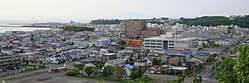 View of Abashiri City | |||
| |||
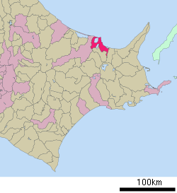 Location of Abashiri in Hokkaido (Okhotsk Subprefecture) | |||
 Abashiri Location in Japan | |||
| Coordinates: 44°1′N 144°16′E / 44.017°N 144.267°ECoordinates: 44°1′N 144°16′E / 44.017°N 144.267°E | |||
| Country | Japan | ||
| Region | Hokkaido | ||
| Prefecture | Hokkaido (Okhotsk Subprefecture) | ||
| Government | |||
| • Mayor | Yōichi Mizutani (since December 2010) | ||
| Area | |||
| • Total | 470.94 km2 (181.83 sq mi) | ||
| Population (August 31, 2011) | |||
| • Total | 38,966 | ||
| • Density | 85.6/km2 (222/sq mi) | ||
| Symbols | |||
| • Tree | Katsura | ||
| • Flower | Ezo murasaki-tsutsuji (Rhododendron dauricum) | ||
| Time zone | UTC+9 (JST) | ||
| City hall address |
Higashi Yon-chōme, Minami Roku-jō, Abashiri-shi, Hokkaidō 093-8555 | ||
| Website |
www | ||


Abashiri (網走市 Abashiri-shi) is a city located in Okhotsk Subprefecture, Hokkaido, Japan.
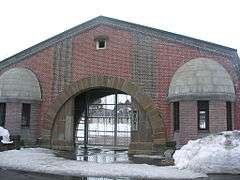
Abashiri is known as the site of the Abashiri Prison, a Meiji-era facility used for the incarceration of political prisoners. The old prison has been turned into a museum, but the city's new maximum-security prison is still in use.
As of 2008, the city has an estimated population of 40,333 and a density of 85.6 persons per km² (222 persons per sq. mi.). The total area is 470.94 km2 (181.83 sq mi).
History
- March 1872: Abashiri Village (アバシリ村) founded, being given the name of Abashiri District in Kitami Province.
- 1875: The village name is rewritten in kanji (網走村, same pronunciation).
- 1902: Abashiri Village, Kitami Town, Isani Village, and Nikuribake Village, all in Abashiri District, merged to form Abashiri Town.
- 1915: Notoro Village, Mokoto Village merged.
- 1921: Memanbetsu Village (later Memanbetsu Town, merged into Ōzora in 2006) split.
- 1931: Boundary with Memanbetsu Town modified.
- February 11, 1947: Higashimokoto Village (merged into Ōzora in 2006) split. Abashiri Town becomes Abashiri City. All of the territories of Ōzora used to be a part of Abashiri.
Geography
Abashiri is located in the eastern part of Okhotsk Subprefecture, about 50 kilometers east of Kitami. There are no tall mountains, but there are many hills. The Abashiri River flows through the city and there are three lakes (Lake Abashiri, Lake Notoro and Lake Tōfutsu) in the city as well. These lakes and Mount Tento belong to Abashiri Quasi-National Park.
Climate
Despite its reputation for extreme cold, Abashiri is not actually the coldest major town in Japan, being less cold in the winter than Obihiro and warmer in summer than Nemuro or Kushiro. Abashiri receives less precipitation than any other city in Japan because its location on the drift ice-affected Sea of Okhotsk,[1] which, however, causes Abashiri to receive less sunshine than the northeast coast since winter snowfall is heavier and fog less confined to the summer months when the Oyashio Current is strongest. During the winter, when Lake Abashiri freezes over, fog becomes a common occurrence.[2] Also, the harbor closes when it ices over.
| Climate data for Abashiri (1981–2010) | |||||||||||||
|---|---|---|---|---|---|---|---|---|---|---|---|---|---|
| Month | Jan | Feb | Mar | Apr | May | Jun | Jul | Aug | Sep | Oct | Nov | Dec | Year |
| Average high °C (°F) | −2.4 (27.7) |
−2.5 (27.5) |
1.6 (34.9) |
8.9 (48) |
14.2 (57.6) |
17.2 (63) |
20.8 (69.4) |
23.4 (74.1) |
20.2 (68.4) |
14.8 (58.6) |
7.4 (45.3) |
0.7 (33.3) |
10.4 (50.6) |
| Daily mean °C (°F) | −5.5 (22.1) |
−6 (21) |
−1.9 (28.6) |
4.4 (39.9) |
9.4 (48.9) |
13.1 (55.6) |
17.1 (62.8) |
19.6 (67.3) |
16.3 (61.3) |
10.6 (51.1) |
3.7 (38.7) |
−2.4 (27.7) |
6.5 (43.7) |
| Average low °C (°F) | −9.4 (15.1) |
−10.1 (13.8) |
−5.5 (22.1) |
0.4 (32.7) |
5.4 (41.7) |
9.8 (49.6) |
14.0 (57.2) |
16.6 (61.9) |
12.9 (55.2) |
6.6 (43.9) |
0.1 (32.2) |
−5.9 (21.4) |
2.9 (37.2) |
| Average precipitation mm (inches) | 54.5 (2.146) |
36.0 (1.417) |
43.5 (1.713) |
52.1 (2.051) |
61.6 (2.425) |
53.5 (2.106) |
87.4 (3.441) |
101.0 (3.976) |
108.2 (4.26) |
70.3 (2.768) |
60.0 (2.362) |
59.4 (2.339) |
787.5 (31.004) |
| Average snowfall cm (inches) | 105 (41.3) |
81 (31.9) |
66 (26) |
21 (8.3) |
1 (0.4) |
0 (0) |
0 (0) |
0 (0) |
0 (0) |
1 (0.4) |
18 (7.1) |
85 (33.5) |
378 (148.9) |
| Average snowy days | 27.0 | 24.1 | 22.3 | 11.2 | 2.4 | 0 | 0 | 0 | 0 | 1.4 | 12.5 | 23.4 | 124.3 |
| Average relative humidity (%) | 73 | 74 | 72 | 69 | 73 | 80 | 83 | 81 | 77 | 70 | 68 | 70 | 74 |
| Mean monthly sunshine hours | 114.3 | 139.4 | 172.4 | 177.8 | 189.0 | 174.0 | 168.7 | 172.1 | 165.2 | 160.1 | 121.3 | 115.0 | 1,869.3 |
| Source: Japan Meteorological Agency | |||||||||||||
Economy
Because of its short 130-day growing season, the crops in the region, such as oats, potatoes, and beans, are required to be hardy. Hay is also grown for local cows, horses, and sheep.[2] The sea is an important part of the community as well as the economy, as fishing, oysters, and seaweed are important means of livelihood.[2]
Transportation
Air
Memanbetsu Airport is located in nearby Ōzora.
Rail
Abashiri is an important local port city and railroad terminal (Abashiri Station).
- Sekihoku Main Line: Yobito - Abashiri
- Senmō Main Line: Abashiri - Katsuradai - Masuura - Mokoto - Kitahama
Education
Universities
- Tokyo University of Agriculture, Okhotsk campus
High schools
- Hokkaido Abashiri Minamigaoka High School
- Hokkaido Abashiri Keiyo High School
Sister city
![]()
Abashiri sights
Hokkaido has a brewery called Abashiri which sells a range of beers,[4][5] including Bilk, a blend of beer and milk.[6] Abashiri is also home to a flower garden with a wide range of flowers.[2]
In the winter, tourists visit the city to watch the drift ice.
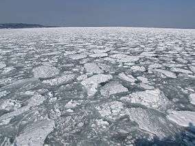 Drift ice off Abashiri
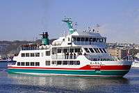 Abashiri's sightseeing ship & icebreaker Aurora II
Museums
- Okhost Ryuhyo Museum
References
- ↑ http://www.climate-charts.com/Countries/Japan.html%5Bpermanent+dead+link%5D
- 1 2 3 4 Kojima, Reikichi (1997). "Abashiri". In Johnston, Bernard. Collier's Encyclopedia. I A to Ameland (First ed.). New York, NY: P.F. Collier. p. 7.
- ↑ Sister city of Abashiri
- ↑ "Abashiri Beer - RateBeer". ratebeer.com. 2011. Retrieved 27 October 2011.
- ↑ "北海道 網走地ビール の網走ビール株式会社|トップページ". www.takahasi.co.jp. Retrieved 2009-08-25.
- ↑ "Milk + Beer = Bilk". Japan Probe. Archived from the original on 2009-07-10. Retrieved 2009-08-25.
External links
| Wikimedia Commons has media related to Abashiri, Hokkaido. |
| Wikivoyage has a travel guide for Abashiri. |
- Official Website (in Japanese)
- Abashiri Prison Museum Official Website (in Japanese)
| ||||||||||
| ||||||||||
| ||||||||||
| ||||||||||
| ||||||||||
| ||||||||||
| ||||||||||
| ||||||||||
| ||||||||||
| ||||||||||
| ||||||||||
| ||||||||||
| ||||||||||
| ||||||||||
| Authority control |
|---|