Tsubetsu, Hokkaido
| Tsubetsu 津別町 | |||
|---|---|---|---|
| Town | |||
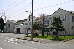 Tsubetsu town | |||
| |||
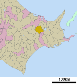 Location of Tsubetsu in Hokkaido (Okhotsk Subprefecture) | |||
 Tsubetsu Location in Japan | |||
| Coordinates: 43°42′N 144°2′E / 43.700°N 144.033°ECoordinates: 43°42′N 144°2′E / 43.700°N 144.033°E | |||
| Country | Japan | ||
| Region | Hokkaido | ||
| Prefecture | Hokkaido (Okhotsk Subprefecture) | ||
| District | Abashiri | ||
| Government | |||
| • Mayor | Taichi Satō | ||
| Area | |||
| • Total | 716.60 km2 (276.68 sq mi) | ||
| Population (September 30, 2016) | |||
| • Total | 5,011 | ||
| • Density | 7.0/km2 (18/sq mi) | ||
| Symbols | |||
| • Tree | Jezo Spruce | ||
| • Flower | Lily of the Valley | ||
| Time zone | UTC+9 (JST) | ||
| City hall address |
41 Aza Sachimachi, Tsubetsu-chō, Abashiri-gun, Hokkaidō 092-0292 | ||
| Website |
www | ||


Tsubetsu (津別町 Tsubetsu-chō) is a town located in Okhotsk Subprefecture, Hokkaido, Japan.
As of September 2016, the town has an estimated population of 5,011 and a population density of 7 persons per km². The total area is 716.60 km².
History
- 1919: Tsubetsu Village founded, split from Bihoro Village (now Town).
- 1921: Part of Bihoro Village incorporated.
- 1946: Tsubetsu Village becomes Tsubetsu Town.
External links

- Official Website (in Japanese)
| ||||||||||
| ||||||||||
| ||||||||||
| ||||||||||
| ||||||||||
| ||||||||||
| ||||||||||
| ||||||||||
| ||||||||||
| ||||||||||
| ||||||||||
| ||||||||||
| ||||||||||
| ||||||||||
This article is issued from
Wikipedia.
The text is licensed under Creative Commons - Attribution - Sharealike.
Additional terms may apply for the media files.