Etymology
The name of the town originates from the word "Hemoi-tomari" in the Ainu language. "Hemoi-tomari" is formed from two Ainu-language words, the first, "hemoi", meaning "trout", and the second, "tomari", meaning "harbor". In the Japanese language the name of the town is written with a single kanji character, 泊, meaning "anchored" or "at anchor". The written form of the name in Japanese is an ateji, or a kanji character used to phonetically represent native or borrowed words.[2][3]
Economy
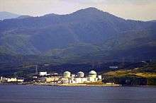
Tomari Nuclear Power Plant
The village is known for fishing and seafood, including sea urchin (uni), sea cucumber (namako) and squid (ika).[2]
Tomari has been linked with energy and power generation since the beginning of the 20th century, giving it its current nickname of "Hometown of Energy". The village is famous for being the site of Hokkaido's only nuclear power plant, the Tomari Nuclear Power Plant. Its first reactor became operational in 1989, and its second in 1991.[2] Tax revenue from the nuclear power plant has ensured that Tomari's local government, unlike most rural villages, operates at a consistent surplus.
History
Historically, the Kayanuma area of the village was a coal mining town. The town was first settled by the Japanese in 1601, and was incorporated as a village in 1880.[3] The villages of Sakazaki, Okishinai, Horikatsubu, and Kayanuma were merged into Tomari in 1909.[1]
Education
- Junior high school
- Tomari Junior High School
- Elementary school
References
- 1 2 "泊村" [Tomari]. Nihon Rekishi Chimei Taikei (in Japanese). Tokyo: Shogakukan. 2012. OCLC 173191044. dlc 2009238904. Archived from the original on 2007-08-25. Retrieved 2012-10-09.
- 1 2 3 4 5 "泊(村)" [Tomari]. Nihon Daihyakka Zensho (Nipponika) (in Japanese). Tokyo: Shogakukan. 2012. OCLC 153301537. Archived from the original on 2007-08-25. Retrieved 2012-10-09.
- 1 2 3 4 泊村の概要 [Outline of Tomari] (in Japanese). Tomari, Hokkaido: Village of Tomari. c. 2012. Retrieved Aug 7, 2012.
External links
Authority control  | |
|---|