Takinoue, Hokkaido
| Takinoue 滝上町 | |||
|---|---|---|---|
| Town | |||
| |||
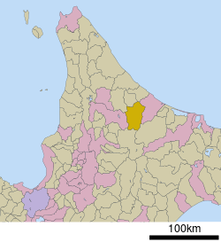 Location of Takinoue in Hokkaido (Okhotsk Subprefecture) | |||
 Takinoue Location in Japan | |||
| Coordinates: 44°12′N 143°5′E / 44.200°N 143.083°ECoordinates: 44°12′N 143°5′E / 44.200°N 143.083°E | |||
| Country | Japan | ||
| Region | Hokkaido | ||
| Prefecture | Hokkaido (Okhotsk Subprefecture) | ||
| District | Monbetsu | ||
| Area | |||
| • Total | 766.89 km2 (296.10 sq mi) | ||
| Population (September 30, 2016) | |||
| • Total | 2,757 | ||
| • Density | 3.6/km2 (9.3/sq mi) | ||
| Symbols | |||
| • Tree | Sakura | ||
| • Flower | Shibazakura | ||
| Time zone | UTC+9 (JST) | ||
| City hall address |
4-2-1 Asahi-machi, Takinoue-cho, Monbetsu-gun, Hokkaido 099-5692 | ||
| Website |
www | ||


Takinoue (滝上町 Takinoue-chō) is a town located in Okhotsk Subprefecture, Hokkaido, Japan. As of September 30, 2016, the town has an estimated population of 2,757 and a population density of 3.6 persons per km². The total area is 766.89 km².
In the Ainu language, the Takinoue area is called Ponkamuikotan which roughly translates to "Village of the Small Gods." The name Takinoue, which literally means "Above the Waterfall," originates from the first Japanese settlers who founded the city upstream from a waterfall.
Takinoue is famous for its mint production and produces 95% of the mint available in Japan. Currently there is about 10 hectors (25 acres) of land dedicated to mint farming.
Takinoue Park is famous for Shibazakura or Pink Moss. The 10,000 m² park attracts thousands of visitors every year between May and June when the flowers are in full bloom.
Geography
Takinoue is surrounded on three sides by mountains. It shares the fourth side with Monbetsu City.
- Mountains: Mt. Wenshiri (1,142m / 0.71 mi); Mt. Kitami-Fuji (1,306m / 0.81 mi); Mt. Teshio (1,558m / 0.97 mi)
- Major Rivers: Shokotsu River; Sakuru River; Oshiraneppu River
Climate
| Climate data for Takinoue | |||||||||||||
|---|---|---|---|---|---|---|---|---|---|---|---|---|---|
| Month | Jan | Feb | Mar | Apr | May | Jun | Jul | Aug | Sep | Oct | Nov | Dec | Year |
| Average high °C (°F) | −2 (28) |
−1 (30) |
3 (37) |
11 (52) |
17 (63) |
22 (72) |
25 (77) |
26 (79) |
22 (72) |
16 (61) |
8 (46) |
1 (34) |
12 (54) |
| Average low °C (°F) | −10 (14) |
−10 (14) |
−5 (23) |
1 (34) |
6 (43) |
11 (52) |
16 (61) |
17 (63) |
12 (54) |
6 (43) |
0 (32) |
−7 (19) |
3 (38) |
| Average precipitation mm (inches) | 128 (5.04) |
93 (3.66) |
64 (2.52) |
57 (2.24) |
96 (3.78) |
61 (2.4) |
113 (4.45) |
146 (5.75) |
136 (5.35) |
115 (4.53) |
118 (4.65) |
140 (5.51) |
1,267 (49.88) |
| Average precipitation days | 25 | 21 | 21 | 19 | 16 | 13 | 15 | 14 | 15 | 19 | 24 | 26 | 228 |
| Source: World Weather Online[1] | |||||||||||||
History
- 1918 - Takinoue Village splits from Shokotsu Village and becomes a second-class municipality under the Monbetsu District.
- 1947 - Takinoue Village becomes Takinoue Town.
- The National Land Agency awards Takinoue 2nd place in the nation for quality of farmed products.[2]
Economy
Takinoue's key industries are forestry, dairy farming, and dry-crop farming.
Agriculture
- Okhotsk Hamanasu Agricultural Cooprative, Takinoue Branch
Banking institutions
- Kitami Credit Union, Takinoue Branch
Postal services
- Takinoue Post Office (Japan Postal Service Center distribution point)
- Nigorikawa Post Office
- Takinishi Post Office
Police
- Takinoue Police Department (a sub-station of Monbetsu Police Department)
Sister cities
Takinoue is twinned with Ochi Town in Kōchi Prefecture.
Education
High schools
- Hokkaido Takinoue High School
Junior high schools
- Takinoue Junior High School
Elementary schools
- Takinoue Elementary School
- Nigorikawa Elementary School
- Takinishi Elementary School- closed 2014
- Shiratori Elementary School- closed 2013
Transportation
Airports
Rail
Takinoue has no rail services.
Bus
Roads
National Highways
Prefectural Highways
- Hokkaidō Route 61 (Shibetsu - Takinoue)
- Hokkaidō Route 137 (Engaru - Takinoue)
- Hokkaidō Route 617 (Oshiraneppu - Nigorikawa)
- Hokkaidō Route 828 (Shiratori - Takinoue)
- Hokkaidō Route 932 (Kamishokotsu - Takinoue)
- Hokkaidō Route 996 (Kamishokotsu - Takinoue)
Sightseeing
- Ukushima Wetlands
- Karinosato Herb Garden
- Kinsenkyo Gorge Walking Path
- Takinoue Park (Shibazakura)
- Yoshokuen Botanical Garden
Festivals
- Shibazakura Festival (May - June)
- Summer Festival of Love (mid August)
References
- ↑ "Takinoue, Japan Weather Averages". World Weather Online. Retrieved 2012-03-28.
- ↑ "Ministry of Agriculture, Forestry and Fisheries: Farming Village Amenities Contest" (in Japanese). Retrieved March 28, 2012.
External links
| Wikimedia Commons has media related to Takinoue, Hokkaidō. |
- Official Website (in Japanese)
| ||||||||||
| ||||||||||
| ||||||||||
| ||||||||||
| ||||||||||
| ||||||||||
| ||||||||||
| ||||||||||
| ||||||||||
| ||||||||||
| ||||||||||
| ||||||||||
| ||||||||||
| ||||||||||