Nakafurano, Hokkaido
| Nakafurano 中富良野町 | |||
|---|---|---|---|
| Town | |||
| |||
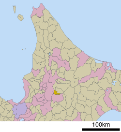 Location of Nakafurano in Hokkaido (Kamikawa Subprefecture) | |||
 Nakafurano Location in Japan | |||
| Coordinates: 43°24′N 142°26′E / 43.400°N 142.433°ECoordinates: 43°24′N 142°26′E / 43.400°N 142.433°E | |||
| Country | Japan | ||
| Region | Hokkaido | ||
| Prefecture | Hokkaido (Kamikawa Subprefecture) | ||
| District | Sorachi | ||
| Area | |||
| • Total | 108.70 km2 (41.97 sq mi) | ||
| Population (April 28, 2017) | |||
| • Total | 5,086 | ||
| • Density | 47/km2 (120/sq mi) | ||
| Time zone | UTC+9 (JST) | ||
| Website |
www | ||


Nakafurano (中富良野町 Nakafurano-chō) is a town located in Kamikawa Subprefecture, Hokkaido, Japan.
As of April 28, 2017, the town has an estimated population of 5,086 and a density of 47 persons per km².[1] The total area is 108.70 km².
Lavender & Farm Tomita
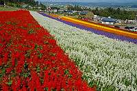
Lavender field in Nakafurano
Furano is famous for its numerous fields of lavender. Farm Tomita (ファーム富田) is one of the many farms in the area which create this reputation by planting giant fields of lavender and other colorful crops such as tulips. Right, is a picture of one of the many scenic vistas available to tourists who visit the farm. The farm also sells many products based on the lavender it produces, from lavender scented candles and soap to lavender flavored drinks and ice cream.
References
- ↑ "Official website of Nakafurano Town" (in Japanese). Japan: Nakafurano Town. Retrieved 16 May 2017.
External links

- Official Website (in Japanese)
- Farm Tomita Website
| ||||||||||
| ||||||||||
| ||||||||||
| ||||||||||
| ||||||||||
| ||||||||||
| ||||||||||
| ||||||||||
| ||||||||||
| ||||||||||
| ||||||||||
| ||||||||||
| ||||||||||
| ||||||||||
This article is issued from
Wikipedia.
The text is licensed under Creative Commons - Attribution - Sharealike.
Additional terms may apply for the media files.