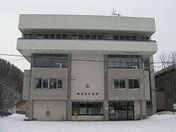
Utashinai, Hokkaido
| Utashinai 歌志内市 | |||
|---|---|---|---|
| City | |||
 Utashinai city hall | |||
| |||
 Location of Utashinai in Hokkaido (Sorachi Subprefecture) | |||
 Utashinai Location in Japan | |||
| Coordinates: 43°31′N 142°2′E / 43.517°N 142.033°ECoordinates: 43°31′N 142°2′E / 43.517°N 142.033°E | |||
| Country | Japan | ||
| Region | Hokkaido | ||
| Prefecture | Hokkaido (Sorachi Subprefecture) | ||
| Government | |||
| • Mayor | Takaoki Murakami | ||
| Area | |||
| • Total | 55.99 km2 (21.62 sq mi) | ||
| Population (April 30, 2017) | |||
| • Total | 3,494 | ||
| • Density | 62/km2 (160/sq mi) | ||
| Symbols | |||
| • Tree | Japanese rowan | ||
| • Flower | Azalea | ||
| • Bird | Japanese bush-warbler | ||
| Time zone | UTC+9 (JST) | ||
| City hall address |
5, Aza Honchō, Utashinai-shi, Hokkaidō 073-0492 | ||
| Website |
www | ||
Utashinai (歌志内市 Utashinai-shi) is a city located in Sorachi Subprefecture, Hokkaido, Japan. It is Japan's smallest city by population.
As of April 30, 2017, the city has an estimated population of 3,494, with 2,015 households,[1] and a density of 62 persons per km2. The total area is 55.99 km2.
History
It was formerly a prosperous coal mining city, but has declined greatly since the closing of the coal mines. The population hit a maximum of 46,000 in 1948.
Efforts to transform Utashinai from a gritty coal mining town to an alpine tourist destination have met with mixed success. The town has adopted a Swiss theme as part of its tourist oriented strategy, and many new buildings are Swiss chalet style. A medium-sized ski hill, Kamoidake, attracts a decent crowd of locals and hosts frequent ski meets, while a hot spring resort called Tyrol, after the Austrian region, is known throughout Hokkaido for the quality of its water. However, despite these new projects, Utashinai continues to experience population decline and economic stagnation. The high school closed in 2007, with students now traveling to Sunagawa, Akabira or Takikawa for their secondary education.
- 1890 - Sorachi Coal Mine opened, founding of Utashinai.
- 1897 - Utashinai Village split away from Nae Village (now the city of Sunagawa).
- 1900 - Ashibetsu Village splits off.
- 1906 - Utashinai becomes a Second Class Municipality.
- 1919 - Utashinai becomes a First Class Municipality.
- 1922 - Akabira Village split off.
- 1940 - Utashinai becomes a town.
- 1949 - Part of the town splits off into Kamisunagawa Town.
- July 1, 1958 - Utashinai becomes a city.
- 1971 - Sumitomo closes Utashinai Mine.
- 1988 - Kamiutashinai Mine closed.
- 1995 - Sorachi Mine closed.
- 2003 - Mid-Sorachi Merger Conference established.
- 2004 - Merger Conference disbanded.
Geography
Penkeutashunai River, a tributary of Ishikari River, flows through Utashinai. There is Mount Kamoi on the northwest of the city.
Name
The name is derived from the Ainu ota-us-nay (オタウㇱナイ) meaning "River connected to a sandy beach".[2]
References
- ↑ "Official website of Utashinai City" (in Japanese). Japan: Utashinai City. Retrieved 14 May 2017.
- ↑ アイヌ語地名リスト [Ainu Language Place Name List] (PDF) (in Japanese). Office of Ainu Measures Promotion, Department of Environment and Lifestyle, Hokkaido Government. Retrieved January 29, 2015.
External links
- Official Website (in Japanese)

