Kyōwa, Hokkaido
| Kyōwa 共和町 | |||
|---|---|---|---|
| Town | |||
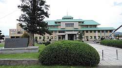 Kyōwa Town hall | |||
| |||
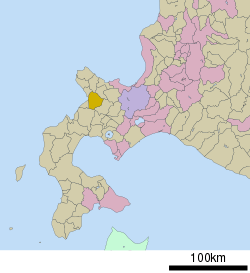 Location of Kyōwa in Hokkaido (Shiribeshi Subprefecture) | |||
 Kyōwa Location in Japan | |||
| Coordinates: 42°59′N 140°37′E / 42.983°N 140.617°ECoordinates: 42°59′N 140°37′E / 42.983°N 140.617°E | |||
| Country | Japan | ||
| Region | Hokkaido | ||
| Prefecture | Hokkaido (Shiribeshi Subprefecture) | ||
| District | Iwanai | ||
| Government | |||
| • Mayor | Eiji Yamamoto | ||
| Area | |||
| • Total | 304.96 km2 (117.75 sq mi) | ||
| Population (September 30, 2016) | |||
| • Total | 6,136 | ||
| • Density | 20/km2 (52/sq mi) | ||
| Symbols | |||
| • Tree | Taxus cuspidata[1] | ||
| • Flower | Menyanthes | ||
| Time zone | UTC+9 (JST) | ||
| City hall address |
38-2 Minamihoroni, Kyōwa, Iwanai-gun, Hokkaido 048-2292 | ||
| Website |
www | ||

Kyōwa (共和町 Kyōwa-chō) is a town located in Shiribeshi Subprefecture, Hokkaido, Japan.
As of September 2016, the town has an estimated population of 6,136, and a density of 20 persons per km². The total area is 304.96 km².
Geography
Kyōwa is located on the southern of the Shakotan Peninsula and the northern of Niseko Volcanic Group.
Neighboring towns and village
History
- 1880: The village of Hattari was founded.[2]
- 1897: The village of Maeda was founded.
- 1901: The village of Kozawa was founded.
- 1906: Hattari Village and Maeda Village became Second Class Villages.
- 1909: Kozawa Village became a Second Class Village.
- 1923: Hattari Village and Maeda Village became First Class Villages.
- 1955: Hattari Village, Maeda Village, and Kozawa Village were merged to form the new village of Kyōwa.
- 1971: Kyōwa Village became Kyōwa Town.
Economics
Kyōwa's main economic activity is farming, with watermelon, Japanese melon, and sweet corn as major crops. In line with the agricultural theme, the town's mascot is the kakashi, or scarecrow, images of which adorn features of the town including brickwork and light posts.
Education
- High school
- Hokkaido Kyōwa High School[3]
- Junior high school
- Kyōwa Junior High School
- Elementary school
- Toyo Elementary School
- Seiryo Elementary School
- Hokushin Elementary School
Transportation
Iwanai Line (Japanese National Railways) used to run through the town from Kozawa Station to Iwanai Station (Iwanai).
References
External links

- Official Website (in Japanese)
| ||||||||||
| ||||||||||
| ||||||||||
| ||||||||||
| ||||||||||
| ||||||||||
| ||||||||||
| ||||||||||
| ||||||||||
| ||||||||||
| ||||||||||
| ||||||||||
| ||||||||||
| ||||||||||
This article is issued from
Wikipedia.
The text is licensed under Creative Commons - Attribution - Sharealike.
Additional terms may apply for the media files.