Kimobetsu, Hokkaido
| Kimobetsu 喜茂別町 | |||
|---|---|---|---|
| Town | |||
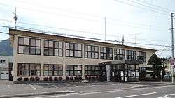 Kimobetsu Town hall | |||
| |||
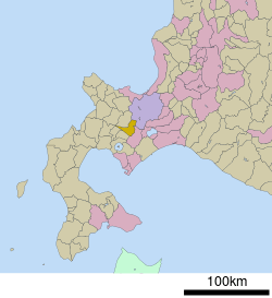 Location of Kimobetsu in Hokkaido (Shiribeshi Subprefecture) | |||
 Kimobetsu Location in Japan | |||
| Coordinates: 42°48′N 140°56′E / 42.800°N 140.933°ECoordinates: 42°48′N 140°56′E / 42.800°N 140.933°E | |||
| Country | Japan | ||
| Region | Hokkaido | ||
| Prefecture | Hokkaido (Shiribeshi Subprefecture) | ||
| District | Abuta | ||
| Government | |||
| • Mayor | Noriaki Sugawara | ||
| Area | |||
| • Total | 189.51 km2 (73.17 sq mi) | ||
| Population (September 30, 2016) | |||
| • Total | 2,286 | ||
| • Density | 12/km2 (31/sq mi) | ||
| Symbols | |||
| • Tree | Prunus sargenti | ||
| • Flower | Impatiens walleriana | ||
| Time zone | UTC+9 (JST) | ||
| City hall address |
123 Kimobetsu, Kimobetsu, Abuta-gun, Hokkaido 044-0292 | ||
| Website |
www | ||


Kimobetsu (喜茂別町 Kimobetsu-chō) is a town located in Shiribeshi Subprefecture, Hokkaido, Japan.
As of September 2016, the town has an estimated population of 2,286 and a population density of 12 persons per km². The total area is 189.51 km².
Geography
Route 230 and Route 276 cross each other in Kimobetsu. Nakayama Pass is on the eastern of the town.
The name derived from Ainu word "kim-o-pet", meaning "The river in the mountain".
- Mountains: Mount Yōtei, Mount Shiribetsu
- Rivers: Shiribetsu River, Kimobetsu River
Neighboring municipalities
History
- 1897: Makkari Village split off from Abuta Village (now Toyako Town).[1]
- 1901: Kaributo Village (now Niseko Town) was split off from Makkari Village.
- 1906: Makkari Village became a Second Class Village.
- 1910: Makkari Village was transferred from Muroran Subprefecture (now Iburi Subprefecture) to Shiribeshi Subprefecture.
- 1917: Kimobetsu Village (now town) was split off from Makkari Village.
- 1946: Kimobetsu Village became a First Class Village.
- 1952: Kimobetsu Village became Kimobetsu Town.
Climate
Due to its mountainous location, Kimobetsu has a humid continental climate (Koppen Dfb). Summers are generally warm and wet, while winters are cold and extremely snowy.
| Climate data for Kimobetsu , Japan (1981~2010) | |||||||||||||
|---|---|---|---|---|---|---|---|---|---|---|---|---|---|
| Month | Jan | Feb | Mar | Apr | May | Jun | Jul | Aug | Sep | Oct | Nov | Dec | Year |
| Record high °C (°F) | 7.1 (44.8) |
11.0 (51.8) |
13.1 (55.6) |
23.8 (74.8) |
28.6 (83.5) |
33.3 (91.9) |
33.0 (91.4) |
33.4 (92.1) |
31.0 (87.8) |
23.5 (74.3) |
18.3 (64.9) |
11.3 (52.3) |
33.4 (92.1) |
| Average high °C (°F) | −2.7 (27.1) |
−2.0 (28.4) |
1.8 (35.2) |
8.8 (47.8) |
15.9 (60.6) |
20.5 (68.9) |
23.7 (74.7) |
25.1 (77.2) |
20.6 (69.1) |
14.0 (57.2) |
6.1 (43) |
−0.4 (31.3) |
11.0 (51.8) |
| Daily mean °C (°F) | −7.4 (18.7) |
−7 (19) |
−2.8 (27) |
3.5 (38.3) |
9.7 (49.5) |
14.6 (58.3) |
18.6 (65.5) |
19.8 (67.6) |
14.7 (58.5) |
8.0 (46.4) |
1.4 (34.5) |
−4.6 (23.7) |
5.7 (42.3) |
| Average low °C (°F) | −14.2 (6.4) |
−14.2 (6.4) |
−9.4 (15.1) |
−2.2 (28) |
3.3 (37.9) |
8.9 (48) |
14.0 (57.2) |
14.9 (58.8) |
8.8 (47.8) |
2.0 (35.6) |
−3.3 (26.1) |
−10.1 (13.8) |
−0.1 (31.8) |
| Record low °C (°F) | −30.9 (−23.6) |
−31.9 (−25.4) |
−25.7 (−14.3) |
−18.5 (−1.3) |
−4.0 (24.8) |
−1.6 (29.1) |
2.4 (36.3) |
4.9 (40.8) |
−1.1 (30) |
−7.3 (18.9) |
−20.6 (−5.1) |
−27.3 (−17.1) |
−31.9 (−25.4) |
| Average precipitation mm (inches) | 90.1 (3.547) |
69.1 (2.72) |
65.8 (2.591) |
64.5 (2.539) |
80.3 (3.161) |
49.5 (1.949) |
101.4 (3.992) |
149.6 (5.89) |
138.8 (5.465) |
114.4 (4.504) |
121.1 (4.768) |
104.4 (4.11) |
1,149.5 (45.256) |
| Average snowfall cm (inches) | 273 (107.5) |
223 (87.8) |
168 (66.1) |
51 (20.1) |
1 (0.4) |
0 (0) |
0 (0) |
0 (0) |
0 (0) |
4 (1.6) |
106 (41.7) |
275 (108.3) |
1,102 (433.9) |
| Source #1: Japan Meteorological Agency[2] | |||||||||||||
| Source #2: Japan Meteorological Agency[3] | |||||||||||||
Education
- Junior high school
- Kimobetsu Junior High School
- Elementary school
- Kimobetsu Elementary School
- Suzukawa Elementary School
See also
References
- ↑ History of Rusutsu
- ↑ "平年値(年・月ごとの値)". Japan Meteorological Agency. Retrieved Feb 22, 2010.
- ↑ "観測史上1~10位の値(年間を通じての値)". Japan Meteorological Agency. Retrieved Feb 22, 2010.
External links

- Official Website (in Japanese)
| ||||||||||
| ||||||||||
| ||||||||||
| ||||||||||
| ||||||||||
| ||||||||||
| ||||||||||
| ||||||||||
| ||||||||||
| ||||||||||
| ||||||||||
| ||||||||||
| ||||||||||
| ||||||||||
This article is issued from
Wikipedia.
The text is licensed under Creative Commons - Attribution - Sharealike.
Additional terms may apply for the media files.