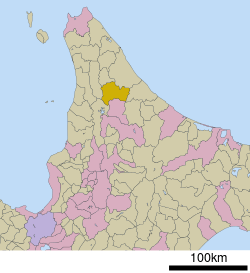
Geography
Bifuka is located in a valley in the north central region of the island of Hokkaido. The town is surrounded by mountains. The Teshio River flows roughly northwest through Bifuka.
Neighboring municipalities
Bifuka borders six other municipalities, which span Kamikawa, Okhotsk, and Sōya subprefectures:
- Kamikawa Subprefecture
- Okhotsk Subprefecture
- Sōya Subprefecture
Museum
Bifuka is home to the Bifuka Sturgeon Museum, a small facility which maintains eight species of sturgeon. Sturgeon were found in the Teshio River as far as Bifuka until the Meiji Period.[2]
Transportation
Bifuka is served by the JR Hokkaido Sōya Line.
The town is linked with Route 40 linking Wakkanai and southern Hokkaido. Another route the Route 275 is also connected.
References
- ↑ 美深町の人口 [Enbetsu] (in Japanese). Bifuka, Hokkaido: Town of Bifuka. 2013. Retrieved 2013-09-12.
- ↑ "美深町チョウザメ館" [Bifuka Sturgeon Museum]. Dijitaru Daijisen (in Japanese). Tokyo: Shogakukan. 2013. OCLC 56431036. Archived from the original on August 25, 2007. Retrieved 2013-09-12.
External links
Authority control  | |
|---|