Saint-Chély-d'Aubrac
| Saint-Chély-d'Aubrac | ||
|---|---|---|
| Commune | ||
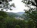
 A general view of Saint-Chély-d'Aubrac | ||
| ||
 Saint-Chély-d'Aubrac Location within Occitanie region  Saint-Chély-d'Aubrac | ||
| Coordinates: 44°35′29″N 2°55′19″E / 44.5914°N 2.9219°ECoordinates: 44°35′29″N 2°55′19″E / 44.5914°N 2.9219°E | ||
| Country | France | |
| Region | Occitanie | |
| Department | Aveyron | |
| Arrondissement | Rodez | |
| Canton | Aubrac et Carladez | |
| Government | ||
| • Mayor (2008–2014) | Jean-Claude Fontanier | |
| Area1 | 78.65 km2 (30.37 sq mi) | |
| Population (2008)2 | 549 | |
| • Density | 7.0/km2 (18/sq mi) | |
| Time zone | UTC+1 (CET) | |
| • Summer (DST) | UTC+2 (CEST) | |
| INSEE/Postal code | 12214 /12470 | |
| Elevation | 560–1,405 m (1,837–4,610 ft) | |
|
1 French Land Register data, which excludes lakes, ponds, glaciers > 1 km2 (0.386 sq mi or 247 acres) and river estuaries. 2 Population without double counting: residents of multiple communes (e.g., students and military personnel) only counted once. | ||
.svg.png)
Saint-Chély-d'Aubrac is a commune in the Aveyron department in southern France about 7 kilometres from Aubrac.
Location
The town is in a large and beautiful green valley on the GR 65, the Way of Saint James pilgrim route. When travelling on the long distance footpath, Saint Chély d'Aubrac is the next town after Aubrac. Going down a wild, wooded valley, the walker discovers this little town in a large clearing and comes into the town by the old bridge with its pilgrim's cross, like the pilgrims of the past.
Population
| Historical population | ||
|---|---|---|
| Year | Pop. | ±% |
| 1793 | 2,034 | — |
| 1800 | 2,383 | +17.2% |
| 1806 | 3,253 | +36.5% |
| 1821 | 3,326 | +2.2% |
| 1831 | 3,289 | −1.1% |
| 1836 | 3,044 | −7.4% |
| 1841 | 2,088 | −31.4% |
| 1846 | 1,994 | −4.5% |
| 1851 | 2,110 | +5.8% |
| 1856 | 1,873 | −11.2% |
| 1861 | 1,697 | −9.4% |
| 1866 | 1,809 | +6.6% |
| 1872 | 1,828 | +1.1% |
| 1876 | 1,815 | −0.7% |
| 1881 | 1,799 | −0.9% |
| 1886 | 1,867 | +3.8% |
| 1891 | 1,760 | −5.7% |
| 1896 | 1,590 | −9.7% |
| 1901 | 1,632 | +2.6% |
| 1906 | 1,600 | −2.0% |
| 1911 | 1,594 | −0.4% |
| 1921 | 1,272 | −20.2% |
| 1926 | 1,241 | −2.4% |
| 1931 | 1,149 | −7.4% |
| 1936 | 1,149 | +0.0% |
| 1946 | 1,082 | −5.8% |
| 1954 | 899 | −16.9% |
| 1962 | 820 | −8.8% |
| 1968 | 726 | −11.5% |
| 1975 | 606 | −16.5% |
| 1982 | 556 | −8.3% |
| 1990 | 547 | −1.6% |
| 1999 | 532 | −2.7% |
| 2008 | 549 | +3.2% |
Landscape
The town has been a member of the Natura 2000 network since August 2006. It hosts an annual chess festival.
Sights
Cooking
Annual chess festival
Gallery
 Saint-Chély: landscape
 Pilgrim's Cross
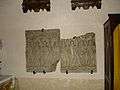 médieval stone
 English possessions XVth
See also
References
External links
| Wikimedia Commons has media related to Saint-Chély-d'Aubrac. |
- zoom and move
- Way of Saint James
- GR65
- The pilgrims' bridge
- Saint Chély photos
- Aubrac's Cows
- The little river of fair water for fishing
- Official site
- Way of Saint-James
- Chemins de Grande Randonnée GR65
- Picture site
- Fishing site
- Aubrac
- Hiking in Saint-Chely d'Aubrac
- Aubrac
- Satellite viewer Zorgloob
This article is issued from
Wikipedia.
The text is licensed under Creative Commons - Attribution - Sharealike.
Additional terms may apply for the media files.