Jeffersontown, Kentucky
| Jeffersontown, Kentucky | ||
|---|---|---|
| City | ||
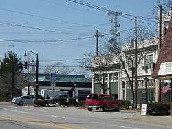 Jeffersontown's Gaslight Square | ||
| ||
| Nickname(s): J-town | ||
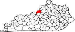
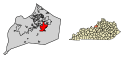 Location of Jeffersontown in Jefferson County, Kentucky. | ||
 Jeffersontown Location within the state of Kentucky  Jeffersontown Jeffersontown (the US) | ||
| Coordinates: 38°12′22″N 85°34′25″W / 38.20611°N 85.57361°WCoordinates: 38°12′22″N 85°34′25″W / 38.20611°N 85.57361°W | ||
| Country | United States | |
| State | Kentucky | |
| County | Jefferson | |
| Incorporated | 1797 | |
| Named for | then-Vice Pres. Thomas Jefferson | |
| Area | ||
| • Total | 10.0 sq mi (25.8 km2) | |
| • Land | 10.0 sq mi (25.8 km2) | |
| • Water | 0.0 sq mi (0.0 km2) | |
| Elevation | 702 ft (214 m) | |
| Population (2010) | ||
| • Total | 26,595 | |
| • Estimate (2016)[1] | 27,352 | |
| • Density | 2,659.5/sq mi (6,888.105/km2) | |
| Time zone | UTC−5 (Eastern (EST)) | |
| • Summer (DST) | UTC−4 (EDT) | |
| ZIP codes | 40220, 40223, 40269, 40291, 40299 | |
| Area code(s) | 502 | |
| FIPS code | 21-40222 | |
| GNIS feature ID | 0495196 | |
| Website | www.jeffersontownky.com | |
Jeffersontown is a home rule-class city[2] in Jefferson County, Kentucky, United States. The population was 26,595 at the 2010 U.S. census.
It is a major suburb of Louisville: when the Louisville Metro government was established in 2003, Jeffersontown remained an independent city. It is the metro area's largest municipality outside Louisville.
History
Located in southeastern Jefferson County, Jeffersontown came into being in the late 1700s as a stopover for early pioneers on their way to the Falls of the Ohio at Louisville. Farmers began to cultivate the rich land, which was surveyed by Thomas Bullitt in 1773 and John Floyd the next year. The Hites, Tylers, and Oldhams all settled the area under land grants for military service.[3]
In 1794, Abraham Bruner purchased 122 acres of land. In May 1797,[4] he successfully petitioned the Jefferson County Fiscal Court to incorporate a 40-acre section of his land as the city of Jefferson – either after the county or after Thomas Jefferson, then the vice president of the United States, directly. The city was long known as Bruner's Town or Brunerstown by its inhabitants, but the usage Jefferson Town eventually led to its present name.[3][5]
Geography
Jeffersontown is located at 38°12′22″N 85°34′25″W / 38.20611°N 85.57361°W (38.206102, -85.573619).[6] According to the United States Census Bureau, the city has a total area of 10.0 square miles (26 km2), of which 9.9 square miles (26 km2) is land and 0.10% is water.
Demographics
As of the census[7] of 2000, there were 26,633 people, 10,653 households, and 7,275 families residing in the city. The population density was 2,675.9 people per square mile (1,033.5/km²). There were 11,220 housing units at an average density of 1,127.3 per square mile (435.4/km²). The racial makeup of the city was 86.74% White, 8.65% African American, 0.21% Native American, 1.77% Asian, 0.03% Pacific Islander, 1.14% from other races, and 1.46% from two or more races. Hispanic or Latino of any race were 2.54% of the population.
There were 10,653 households out of which 32.9% had children under the age of 18 living with them, 54.3% were married couples living together, 10.7% had a female householder with no husband present, and 31.7% were non-families. 26.4% of all households were made up of individuals and 6.4% had someone living alone who was 65 years of age or older. The average household size was 2.46 and the average family size was 2.99.
| Historical population | |||
|---|---|---|---|
| Census | Pop. | %± | |
| 1860 | 315 | — | |
| 1880 | 243 | — | |
| 1890 | 348 | 43.2% | |
| 1910 | 345 | — | |
| 1920 | 350 | 1.4% | |
| 1930 | 614 | 75.4% | |
| 1940 | 899 | 46.4% | |
| 1950 | 1,246 | 38.6% | |
| 1960 | 3,431 | 175.4% | |
| 1970 | 9,701 | 182.7% | |
| 1980 | 15,795 | 62.8% | |
| 1990 | 23,221 | 47.0% | |
| 2000 | 26,633 | 14.7% | |
| 2010 | 26,595 | −0.1% | |
| Est. 2016 | 27,352 | [1] | 2.8% |
| U.S. Decennial Census[8] | |||
In the city, the population was spread out with 24.8% under the age of 18, 7.7% from 18 to 24, 33.4% from 25 to 44, 23.3% from 45 to 64, and 10.8% who were 65 years of age or older. The median age was 36 years. For every 100 females, there were 92.8 males. For every 100 females age 18 and over, there were 89.1 males.
The median income for a household in the city was $51,999, and the median income for a family was $60,951. Males had a median income of $41,345 versus $29,537 for females. The per capita income for the city was $23,977. About 3.7% of families and 4.3% of the population were below the poverty line, including 5.4% of those under age 18 and 5.4% of those age 65 or over.
Economy
The Bluegrass Commerce Park (formerly known as The Bluegrass Research & Industrial Park) opened on 600 acres (2.4 km2) in 1966. Created with an attractive, park-like setting, it was the first such development in the United States. Today, Bluegrass Commerce Park takes in over 1,800 acres (7.3 km2) and is home to approximately 850 businesses. The park is the largest in the state of Kentucky, and the 38,000 employees make the park and Jeffersontown the third-largest city of employment in the state.[9] The park's seven units include:
- Bluegrass Commerce Park
- Commonwealth Park
- Watterson Trail Industrial Park
- Plainview Office Park
- Jeffersontown Industrial Park
- Holloway Industrial Park
- Blankenbaker Crossings
Papa John's Pizza has its headquarters in Jeffersontown.[10][11]
Government
The city of Jeffersontown is governed by a mayor and eight city council members. The mayor serves a four-year term of office while the council members serve two-year terms. The city council is elected from the top eight candidates receiving the most votes in the general election.
- Jeffersontown Mayor, 2015–2018
- Bill Dieruf
Jeffersontown City Council, 2017–2018 (listed by vote count)
- Ray Perkins (7,712)
- Carol Pike (7,358)
- Pam Ware (6,937)
- Vince Grisanti (6,740)
- Mark Blum (5,868)
- Tim Hall (5,638)
- Brian Abrams (5,449)
- Bill Young^
^Bill Young was appointed by the city council to serve the remainder of Kristina Dreisbach’s term.
Notable people
- Jon Ackerson, former member of both houses of the Kentucky State Legislature; former Jeffersontown city council member
References
- 1 2 "Population and Housing Unit Estimates". Retrieved June 9, 2017.
- ↑ "Summary and Reference Guide to House Bill 331 City Classification Reform" (PDF). Kentucky League of Cities. Retrieved December 30, 2014.
- 1 2 The Kentucky Encyclopedia, pp. 468. "Jeffersontown". University Press of Kentucky (Lexington), 1992. Accessed 1 August 2013.
- ↑ Commonwealth of Kentucky. Office of the Secretary of State. Land Office. "Jeffersontown, Kentucky". Accessed 1 August 2013.
- ↑ Rennick, Robert. Kentucky Place Names, p. 152. University Press of Kentucky (Lexington), 1987. Accessed 1 August 2013.
- ↑ "US Gazetteer files: 2010, 2000, and 1990". United States Census Bureau. 2011-02-12. Retrieved 2011-04-23.
- ↑ "American FactFinder". United States Census Bureau. Retrieved 2008-01-31.
- ↑ "Census of Population and Housing". Census.gov. Archived from the original on May 12, 2015. Retrieved June 4, 2015.
- ↑ "Jeffersontown, Kentucky – Viewbook". Communitylink.com. 2003-01-06. Retrieved 2009-08-05.
- ↑ "Jeffersontown to dedicate new bike and walking path Saturday." The Courier-Journal. November 7, 2007. C7. Retrieved on December 6, 2012. "Papa John's office is in Jeffersontown,"
- ↑ "Papa's Specialty Pizza Challenge Archived 2014-10-23 at the Wayback Machine.." Papa John's Pizza. Retrieved on December 6, 2012. "Papa John's International Inc., 2002 Papa John's Blvd, Louisville, KY 40299."
External links
- City website
- History of Jeffersontown
- "Jeffersontown: Huge Family Farms, Buffalo, Linn Station Fort Marked Landscape; Diseases Delayed Growth" – Article by M. David Goodwin of The Courier-Journal
Places in Louisville Metro | ||||||||||
|---|---|---|---|---|---|---|---|---|---|---|
| ||||||||||
| History |
|  |
|---|---|---|
| Geography |
| |
| Government |
| |
| Transportation | ||
| Other subject areas | ||
| Top subjects | ||
| National Historic Landmarks | ||
| Prominent suburbs (over 10K pop.) | ||
| ||
