Del Rio, Florida
| Del Rio, Florida | |
|---|---|
| Unincorporated community | |
 Del Rio  Del Rio | |
| Coordinates: 28°0′50″N 82°24′4″W / 28.01389°N 82.40111°WCoordinates: 28°0′50″N 82°24′4″W / 28.01389°N 82.40111°W | |
| Country | United States |
| State | Florida |
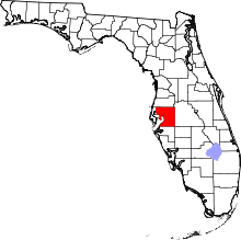
| County | Hillsborough |
| Time zone | UTC-5 (Eastern (EST)) |
| • Summer (DST) | UTC-4 (EDT) |
| ZIP codes | 33617 |
| Area code(s) | 813 |
| GNIS feature ID | 1867134 |
Del Rio is an unincorporated, urban community in Hillsborough County, Florida, United States, between Tampa and Temple Terrace, near the Hillsborough River. The community is known as "The Fishbowl" to locals because many streets in the area are named for fish. Del Rio is included within the East Lake-Orient Park census-designated place.
Description
| Historical population | |||
|---|---|---|---|
| Census | Pop. | %± | |
| 1980 | 7,409 | — | |
| 1990 | 8,248 | 11.3% | |
| source:[1] | |||
Del Rio is bounded by Tampa to the west, the Hillsborough River to the north, U.S. Route 92 to the south, and 56th Street (SR 583) to the east.
History
Del Rio was laid out in the 1950s and 1960s as one of the suburban communities of Tampa. The community grew rapidly during the 1960s and 1970s. Its peak population according to the Census was 8,248 in 1990.[2]
Schools serving the area
References
- ↑ "CENSUS OF POPULATION AND HOUSING (1790-2000)". U.S. Census Bureau. Retrieved 2010-07-17.
- ↑ U.S. Geological Survey Geographic Names Information System: Del Rio, Florida. Retrieved 2013-12-14.
This article is issued from
Wikipedia.
The text is licensed under Creative Commons - Attribution - Sharealike.
Additional terms may apply for the media files.