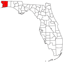
Pensacola metropolitan area
| Pensacola Metropolitan Area | |
|---|---|
| Pensacola-Ferry Pass-Brent | |
 | |
| Country | United States |
| State(s) | Florida |
| Largest city | Pensacola, Florida |
| Other cities |
Navarre, Florida Gulf Breeze, Florida Milton, Florida Jay, Florida Pace, Florida Ensley, Florida Warrington, Florida Brent, Florida Ferry Pass, Florida McDavid, Florida Pensacola Beach, Florida Cantonment, Florida Perdido Key, Florida Myrtle Grove, Florida Walnut Hill, Florida West Pensacola, Florida Molino, Florida Innerarity Point, Florida Goulding, Florida Gonzalez, Florida Barrineau Park, Florida Beulah, Florida |
| Area | |
| • Total | 2,049 sq mi (5,310 km2) |
| Highest elevation | Sunny Hill 205 ft (62.484 m) |
| Population (2010 ces.) | |
| • Total | 448,991 |
| • Rank | 110 in the U.S. |
| • Density | 219.12/sq mi (230.99/km2) |
The Pensacola metropolitan area is the metropolitan area centered on Pensacola, Florida. It is also known as the Pensacola-Ferry Pass-Brent Metropolitan Statistical Area, a metropolitan statistical area (MSA) used for statistical purposes by the United States Census Bureau and other agencies. The Pensacola Standard Metropolitan Statistical Area was first defined after the 1960 United States Census, with Pensacola as the principal city, and included Escambia and Santa Rosa counties. Ferry Pass and Brent, which are unincorporated census-designated places in Escambia County, were added as principal cities after the 2000 Census. [1] The population of the MSA in the 2010 census was 448,991. The estimated population of the MSA was 487,784 in 2017.[2]
The four incorporated cities within the MSA are Pensacola (Population: 51,923), Milton (8,866), Gulf Breeze (6,466), Century (1,786), and Jay (590). In addition, several unincorporated census designated places account for a great number of the population. Most notable is Navarre (Population: 42,200); its population makes it the second largest community in the metro area, only behind Pensacola.
Demographics
As of the census[3] of 2010, there were 448,991 people residing within the MSA. The racial makeup of the MSA was 75.3% White, 17.0% African American, 0.9% Native American, 2.4% Asian, 0.1% Pacific Islander, 1.2% from other races, and 3.1% from two or more races. Hispanic or Latino of any race were 4.6% of the population.
Economy
Personal income
The median income for a household in the MSA was $38,558, and the median income for a family was $44,319. Males had a median income of $32,966 versus $22,164 for females. The per capita income for the MSA was $19,365.
Tourism
Tourism in the Pensacola Bay area brings in about $552 million annually.[4] Palafox Place contains multiple venues for nightlife.
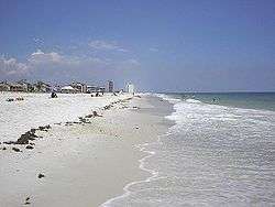
Beaches
Retail
Transportation
Commercial airports
| Airport | IATA code | ICAO code | County |
|---|---|---|---|
| Pensacola International Airport | PNS | KPNS | Escambia |
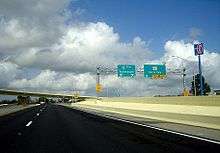
Interstate Highways


U.S. Highways
State Highways
Codes of metropolitan Pensacola
Area Codes
ZIP codes
The following is the list of ZIP codes for selected areas within the metropolitan area.
- 32501 in Pensacola, Downtown north of Wright Street
- 32502 in Pensacola, Downtown south of Wright Street
- 32503 in Pensacola, East of Palafox Street
- 32504 in Pensacola, Northeast Pensacola
- 32505 in Pensacola, Inner western suburbs
- 32506 in Pensacola, Western suburbs
- 32507 in Pensacola, Warrington and Perdido Key
- 32508 in Pensacola, Naval Air Station Pensacola
- 32509 in Pensacola, NOLF Saufley Field
- 32511 in Pensacola, Corry Station Naval Technical Training Center
- 32512 in Pensacola, Naval Hospital Pensacola
- 32513 in Pensacola
- 32514 in Pensacola, Northern suburbs including Ferry Pass
- 32516 in Pensacola
- 32520 in Pensacola, used by Gulf Power
- 32521 in Pensacola, used by the City of Pensacola
- 32522 in Pensacola
- 32523 in Pensacola
- 32524 in Pensacola
- 32526 in Pensacola, Northwestern suburbs including Bellview and Beulah
- 32533 in Cantonment
- 32534 in Ensley
- 32559 in Pensacola
- 32560 in Gonzalez
- 32568 in McDavid, Walnut Hill
- 32577 in Molino
- 32591 in Pensacola
- 32530 in Bagdad
- 32561 in Gulf Breeze
- 32562 in Gulf Breeze
- 32563 in Gulf Breeze
- 32564 in Holt, spills over into eastern Santa Rosa County from Okaloosa County.
- 32565 in Jay
- 32566 in Navarre
- 32570 in Milton
- 32571 in Pace
- 32572 in Milton
- 32583 in Milton
Culture
.JPG)
Museums
Sports
Sports teams
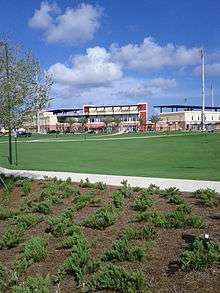
- Double-A Baseball Teams
- Ice Hockey
See also
References
- ↑ Metropolitan and Micropolitan Statistical Area Definitions - retrieved July 17, 2006
- ↑ "American Fact Finder - Community Facts - Table Viewer". U.S. Census Bureau. March 2018. Retrieved 27 June 2018.
- ↑ "American FactFinder". United States Census Bureau. Retrieved 2008-01-31.
- ↑ Fahrenthold, David A. (2 May 2010). "Obama to survey environmental damage in gulf". Washington, DC: Washington Pose. pp. A6.
| Counties | | |
|---|---|---|
| Major city | ||
| Incorporated Cities | ||
| Unincorporated | ||
| Topics |  | |
|---|---|---|
| Government | ||
| Region | ||
| ||

| Topics |  Map of North Florida | |
|---|---|---|
| Counties | ||
| Major cities | ||
| Cities and towns 100k+ | ||
| Cities and towns 25k–100k | ||
| Cities and towns 10k–25k | ||
| Metro areas | ||
| Regions | ||