Mango, Florida
| Mango, Florida | |
|---|---|
| Census-designated place | |
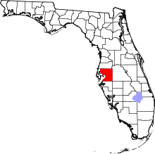
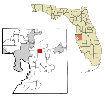 Location in Hillsborough County and the state of Florida | |
| Coordinates: 27°59′22″N 82°18′16″W / 27.98944°N 82.30444°WCoordinates: 27°59′22″N 82°18′16″W / 27.98944°N 82.30444°W | |
| Country | United States |
| State | Florida |
| County | Hillsborough |
| Area | |
| • Total | 4.8 sq mi (12.4 km2) |
| • Land | 4.7 sq mi (12.1 km2) |
| • Water | 0.2 sq mi (0.4 km2) |
| Elevation | 52 ft (16 m) |
| Population (2010) | |
| • Total | 11,313 |
| • Density | 2,427/sq mi (937.0/km2) |
| Time zone | UTC-5 (Eastern (EST)) |
| • Summer (DST) | UTC-4 (EDT) |
| ZIP code | 33550 |
| Area code(s) | 813 |
| FIPS code | 12-42850[1] |
| GNIS feature ID | 0286372[2] |
Mango is a census-designated place (CDP) in Hillsborough County, Florida, United States. The population was 11,313 at the 2010 census,[3] up from 8,842 at the 2000 census.
Geography
Mango is located north of the geographic center of Hillsborough County at 27°59′22″N 82°18′16″W / 27.98944°N 82.30444°W (27.989333, -82.304395).[4] It is bordered to the north by Thonotosassa, to the east by Seffner, to the south by Brandon, and to the west by East Lake-Orient Park. Interstate 4 forms the northern boundary of the CDP, and Interstate 75 is the western boundary. The main road through the center of Mango is Dr. Martin Luther King Jr. Boulevard (Florida State Road 574). Downtown Tampa is 10 miles (16 km) to the west, and Plant City is 12 miles (19 km) to the east.
According to the United States Census Bureau, the Mango CDP has a total area of 4.8 square miles (12.4 km2), of which 4.7 square miles (12.1 km2) are land and 0.1 square miles (0.3 km2), or 2.95%, are water.[3]
Demographics
| Historical population | |||
|---|---|---|---|
| Census | Pop. | %± | |
| 1990 | 8,700 | — | |
| 2000 | 8,842 | 1.6% | |
| 2010 | 11,313 | 27.9% | |
| source:[5] | |||
As of the census[1] of 2000, there were 8,842 people, 3,289 households, and 2,302 families residing in the community. The population density was 1,927.1 people per square mile (743.8/km²). There were 3,617 housing units at an average density of 788.3/sq mi (304.3/km²). The racial makeup of the community was 86.97% White, 6.44% African American, 0.58% Native American, 0.72% Asian, 0.05% Pacific Islander, 2.40% from other races, and 2.85% from two or more races. Hispanic or Latino of any race were 9.16% of the population.
There were 3,289 households out of which 37.0% had children under the age of 18 living with them, 46.0% were married couples living together, 17.1% had a female householder with no husband present, and 30.0% were non-families. 22.1% of all households were made up of individuals and 6.2% had someone living alone who was 65 years of age or older. The average household size was 2.68 and the average family size was 3.10.
In the community the population was spread out with 29.1% under the age of 18, 8.7% from 18 to 24, 32.8% from 25 to 44, 21.0% from 45 to 64, and 8.4% who were 65 years of age or older. The median age was 33 years. For every 100 females, there were 100.8 males. For every 100 females age 18 and over, there were 96.3 males.
The median income for a household in the community was $33,989, and the median income for a family was $37,818. Males had a median income of $29,038 versus $22,947 for females. The per capita income for the community was $15,478. About 9.1% of families and 12.6% of the population were below the poverty line, including 20.1% of those under age 18 and 4.0% of those age 65 or over.
By 2010 the census showed 11,313 people, a 28% increase over 2000.
Population change by race:
| Race group | Population (2000) | Percentage (2000) | Population (2010) | Percentage (2010) | Numeric change | Percent change |
|---|---|---|---|---|---|---|
| American Indian and Alaska native alone | 51 | 0.58% | 85 | 0.75% | 34 | 66.67% |
| Asian alone | 64 | 0.72% | 173 | 1.53% | 109 | 170.31% |
| Black or African American alone | 569 | 6.44% | 1,744 | 15.42% | 1,175 | 206.50% |
| Native Hawaiian and Other Pacific native alone | 4 | 0.05% | 18 | 0.16% | 14 | 350.00% |
| Some other race alone | 212 | 2.40% | 881 | 7.79% | 669 | 315.57% |
| Two or more races | 252 | 2.85% | 346 | 3.06% | 94 | 37.30% |
| White alone | 7,690 | 86.97% | 8,066 | 71.30% | 376 | 4.89% |
See also
- Mango-Seffner, Florida, a single census area recorded during the 1980 Census.
References
- 1 2 "American FactFinder". United States Census Bureau. Retrieved 2008-01-31.
- ↑ "US Board on Geographic Names". United States Geological Survey. 2007-10-25. Retrieved 2008-01-31.
- 1 2 "Geographic Identifiers: 2010 Demographic Profile Data (G001): Mango CDP, Florida". American Factfinder. U.S. Census Bureau. Retrieved May 4, 2017.
- ↑ "US Gazetteer files: 2010, 2000, and 1990". United States Census Bureau. 2011-02-12. Retrieved 2011-04-23.
- ↑ "CENSUS OF POPULATION AND HOUSING (1790-2000)". U.S. Census Bureau. Retrieved 2010-07-17.