Port Sutton, Florida
| Port Sutton, Florida | |
|---|---|
| Unincorporated community | |
 Port Sutton  Port Sutton | |
| Coordinates: 27°54′25″N 82°25′15″W / 27.90694°N 82.42083°WCoordinates: 27°54′25″N 82°25′15″W / 27.90694°N 82.42083°W | |
| Country | United States |
| State | Florida |
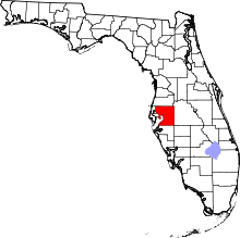
| County | Hillsborough |
| Time zone | UTC-5 (Eastern (EST)) |
| • Summer (DST) | UTC-4 (EDT) |
| ZIP code | 33619 |
| Area code(s) | 813 |
| GNIS feature ID | 295811 |
Port Sutton is an unincorporated community located in the industrial section of southeastern Hillsborough County, Florida, United States. The community is served by a 33619 ZIP Code.[1] It is adjacent to the census-designated place (CDP) of Palm River-Clair Mel and the city limits of Tampa.[2]
Geography
Port Sutton is located at latitude 27.907 north, longitude -82.421 west,[3] or approximately four miles southeast of Tampa.[4] The elevation of the community is three feet above sea level.[5]
Education
The community of Port Sutton is served by Hillsborough County Schools, which serves the entire county.[6]
References
- ↑ Place and ZIP Code Finder – Key Word: Port Sutton , FL. Retrieved September 18, 2013
- ↑ URBANIZED AREA OUTLINE MAP (CENSUS 2000) Tampa-St. Petersburg, FL. Retrieved September 18, 2013
- ↑ "US Gazetteer files: 2010, 2000, and 1990". United States Census Bureau. February 12, 2011. Retrieved April 23, 2011.
- ↑ Port Sutton page from Hometown Locator. Retrieved September 18, 2013.
- ↑ Port Sutton page from Hometown Locator. Retrieved September 18, 2013.
- ↑ Port Sutton Schools & Education
External links
This article is issued from
Wikipedia.
The text is licensed under Creative Commons - Attribution - Sharealike.
Additional terms may apply for the media files.