Big Bend (Florida)
The Big Bend region of Florida, United States, is an informal region of the state. Different definitions of the region include counties stretching across northern Florida from the Apalachicola River to the St. Johns River. The Big Bend Coast, however, is the marshy coast without barrier islands that extends along the Gulf of Mexico coast of Florida from the Ocklockonee River (Wakulla County) to Anclote Key (Pasco County).
Visit Florida, the state's official tourism marketing corporation,[1] uses varying definitions of the region, including just four counties, Jefferson, Taylor, Dixie and Levy counties, in one definition,[2] and 12 counties, including Levy, Dixie, Gilchrist, Lafayette, Suwannee, Columbia, Hamilton, Baker, Union, Bradford, Clay, and Putnam counties, in another.[3] The Big Bend Scenic Byway is a marked route through Franklin, Leon, and Wakulla counties.[4]
Private agencies that self-identify as serving the Big Bend region often include Franklin, Gadsden, Jefferson, Leon, Liberty, Madison, Taylor and Wakulla counties in their service areas.[5][6][7] The principal city in the region is Tallahassee.
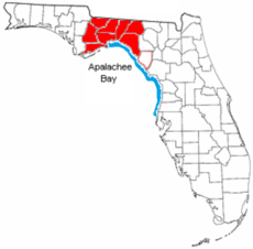
The Big Bend Coast is the marshy coast extending about 350 kilometres (220 mi) from the mouth of the Ocklockonee River around Apalachee Bay and down the west coast of peninsular Florida to Anclote Key. This stretch of coast includes the coasts of Wakulla, Jefferson, Taylor, Dixie, Levy, Citrus, Hernando and Pasco counties. The Big Bend Coast is a drowned karst region, covered with salt marsh. It includes freshwater springs, oyster reefs, and the delta of the Suwannee River. There are barrier islands west of the Oklockonee River and south starting with Anclote Key, but there are no barrier islands between those places. The Big Bend Coast has little or no sand or mud. The karst topography has produced an irregular, frequently exposed, bedrock surface. Due to the width of the adjacent continental shelf (over 150 kilometres (93 mi)), low gradient slope of the coast (1:5000), and shelter from the usual wind direction of storms, the Big Bend Coast is generally subject to low wave energy. The coast is subject to storm surges.[8][9][10][11]
See also
References
- ↑ "About Us". Visit Florida. Retrieved March 22, 2018.
- ↑ Moreland, Nancy. "What to Do in Florida's Big Bend". Visit Florida. Retrieved May 22, 2018.
- ↑ McKechnie, Gary. "Discover the Big Bend of Florida: a Road Trip to Rural". Visit Florida. Retrieved May 22, 2018.
- ↑ Colon, Dalia. "Big Bend Scenic Byway: Big on Wildlife". Visit Florida. Retrieved May 22, 2018.
- ↑ "Big Bend Region", Early Learning Coalition, FL, USA, retrieved June 17, 2011 .
- ↑ "Paralegal Association of Florida, Big Bend Chapter". Archived from the original on 25 January 2009. Retrieved 13 December 2014.
- ↑ "Neighboring Counties". United Way of the Big Bend. Retrieved 13 December 2014.
- ↑ Mattson, Robert A.; Frazer, Thomas K.; Hale, Jason; Blitch, Seth; Ajijevych, Lisa. "Florida Big Bend" (PDF). United States Geological Survey. Retrieved 13 December 2014.
- ↑ A Photo Gallery of Florida's Big Bend Tidal Wetlands, USA: USGS .
- ↑ "Status of Knowledge in Florida's Big Bend", GSA, USA: Confex, 2004 .
- ↑ Randazzo, Anthony F.; Jones, Douglas S., eds. (1997). The Geology of Florida. Gainesville, Florida: University Press of Florida. pp. 4, 165–66. ISBN 0-8130-1496-4.

| Topics |  Map of North Florida | |
|---|---|---|
| Counties | ||
| Major cities | ||
| Cities and towns 100k+ | ||
| Cities and towns 25k–100k | ||
| Cities and towns 10k–25k | ||
| Metro areas | ||
| Regions | ||