Clair-Mel City, Florida
| Clair-Mel City, Florida | |
|---|---|
| Unincorporated community | |
 Clair-Mel City  Clair-Mel City | |
| Coordinates: 27°56′0″N 82°22′42″W / 27.93333°N 82.37833°WCoordinates: 27°56′0″N 82°22′42″W / 27.93333°N 82.37833°W | |
| Country | United States |
| State | Florida |
| County | Hillsborough |
| Area | |
| • Land | 0.64 sq mi (1.66 km2) |
| Time zone | UTC-5 (Eastern (EST)) |
| • Summer (DST) | UTC-4 (EDT) |
| ZIP code | 33619 |
| Area code(s) | 813 |
| GNIS feature ID | 301140 |
Clair-Mel City (Clair Mel) is an unincorporated community in Hillsborough County, Florida, United States. The community is combined with Palm River to form the census-designated place of Palm River-Clair Mel.
Geography
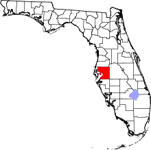
Clair Mel City is located at 27.93 North, 82.38 West (27.933359, -82.37821),[1] or approximately 7 miles (11 km) east-southeast of Tampa.
Description
Clair boundaries include Palm River to the west, Tampa city limits to the north, the Lee Roy Selmon Expressway to the east, and Progress Village to the south.
References
- ↑ "US Gazetteer files: 2010, 2000, and 1990". United States Census Bureau. 2011-02-12. Retrieved 2011-04-23.
External links
This article is issued from
Wikipedia.
The text is licensed under Creative Commons - Attribution - Sharealike.
Additional terms may apply for the media files.