Provinces of Japan
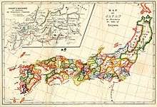
Provinces of Japan (令制国 Ryōseikoku) were administrative divisions before the modern prefecture system was established, when the islands of Japan were divided into tens of kuni (国, countries), usually known in English as provinces.[1] Each province was divided into gun (郡, districts, earlier called kōri).
The provinces of ancient Japan were in effect from the 7th century until the Meiji period. To date, no official order has been issued abolishing the ancient provinces. Nonetheless, today they are considered obsolete. What follows is a list of the individual provinces along with some details.
The borders of the provinces changed until the end of the Nara period and during the Meiji period. From the Heian period until the Edo period, the borders remained unchanged. For the demographic data of provinces during Edo period, see Demographics of Japan before Meiji Restoration.
History
The provinces were originally established by Ritsuryō as both administrative units and geographic regions.
In the late Muromachi period, however, their function was gradually supplanted by the domains of the sengoku daimyō. Under the rule of Toyotomi Hideyoshi, the provinces were supplemented as primary local administrative units. The local daimyōs' fiefs were developed.[2]
Edo period
In the Edo period, the fiefs became known as han. Imperial provinces and shogunal domains made up complementary systems. For example, when the shōgun ordered daimyō to make a census or to make maps, the work was organized in terms of the boundaries of the provincial kuni.[3]
Meiji period
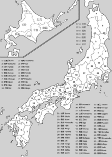
At the Meiji Restoration, the han were legitimized as administrative units under Fuhanken Sanchisei, but were gradually replaced by prefectures between 1868 and 1871 (urban prefectures were called fu and rural prefectures ken). Provinces as part of the system of addresses were not abolished but, on the contrary, augmented. As of 1871, the number of prefectures was 304, while the number of provinces was 68, not including Hokkaidō or the Ryūkyū Islands. The boundaries between the many prefectures were not only very complicated, but also did not match those of the provinces. Prefectures were gradually merged to reduce the number to 37 by 1881; a few were then divided to give a total of 45 by 1885. Adding Hokkaidō and Okinawa produced the current total of 47 prefectures.
Provinces are classified into Kinai (within the capital), and seven or eight dō (routes, or circuits), collectively known as the Gokishichidō. However, dō in this context should not be confused with modern traffic lines such as Tōkaidō from Tokyo to Kyoto or Kobe. Also, Hokkaidō in this context should not be confused with Hokkaidō Prefecture, although these two overlap geographically.
Today
To date, no official order has been issued abolishing provinces. Provinces are nonetheless today considered obsolete, although their names are still widely used in names of natural features, company names, and brands. In the early 2000s, former governor of Nagano Prefecture, Yasuo Tanaka (president of New Party Nippon), proposed the renaming of his prefecture to "Shinshū" (信州, a name derived from Shinano Province) because it is still widely used, as in Shinshū soba (信州そば), Shinshū miso (信州味噌) and Shinshu University.
These province names are considered to be mainly of historical interest. They are also used for the names of items, including family names, most of which were popularized in or after the Edo period. Examples include sanuki udon, iyokan, tosa ken, and awa odori. Japan Rail stations also use them in names to, aside from the historical background, distinguish themselves from similarly named stations in other prefectures.
Some of the province names are used to indicate distinct parts of the current prefectures along with their cultural and geographical characteristics. In many cases these names are also in use with directional characters, e.g. Hoku-Setsu (北摂) meaning Northern (北) Settsu (摂津) area.
The districts are still considered prefectural subdivisions, however in case of being part of a merger or division of old provinces, they may be shared among several prefectures (such as the original Adachi District of Musashi, which is now divided between Adachi Ward of Tokyo and Kita-Adachi District in Saitama). Many of these old provincial districts have been dissolved as their chief towns have merged into larger cities or towns. See individual prefecture pages for mergers and abolitions of districts.
The following list is based on the Gokishichidō (五畿七道), which includes short-lived provinces. Provinces located within Hokkaidō are listed last.
Goki (五畿 Five Provinces in Capital Region)
Kinai (畿内 Capital Region)
- Yamashiro (Jōshū, Sanshū, Yōshū) (山城国 (城州, 山州, 雍州))
- Yamato (Washū) (大和国 (和州))
- Kawachi (Kashū) (河内国 (河州))
- Izumi (Senshū) (和泉国 (泉州)) - Created in 716 from Kawachi Province as Izumi Gen (和泉監). Although occupied by Kawachi Province in 740, in 757 the province divided again from Kawachi Province.
- Settsu (Sesshū) (摂津国 (摂州))
Shichido (七道 Seven Circuits)
Tōkaidō (東海道 East Sea Circuit)
- Iga (Ishū) (伊賀国 (伊州)) – separated from Ise Province in 680
- Ise (Seishū) (伊勢国 (勢州))
- Shima (Shishū) (志摩国 (志州)) – separated from Ise Province at the beginning of the 8th century
- Owari (Bishū) (尾張国 (尾州))
- Mikawa (Sanshū) (三河国 (三州))
- Tōtōmi (Enshū) (遠江国 (遠州))
- Suruga (Sunshū) (駿河国 (駿州))
- Izu (Zushū) (伊豆国 (豆州)) – separated from Suruga Province in 680
- Kai (Kōshū) (甲斐国 (甲州))
- Sagami (Sōshū) (相模国 (相州))
- Musashi (Bushū) (武蔵国 (武州)) – Transferred from Tōsandō to Tōkaidō in 771
- Awa (Bōshū, Anshū) (安房国 (房州, 安州)) – Divided from Kazusa Province in 718. Although re-joined to Kazusa Province in 741, separated from Kazusa Province again in 781
- Kazusa (Sōshū) (上総国 (総州)) – divided from Fusa Province (総国) in the 7th century
- Shimōsa (Sōshū) (下総国 (総州)) – divided from Fusa Province in the 7th century
- Hitachi (Jōshū) (常陸国 (常州))
Tōsandō (東山道 East Mountain Circuit)
- Ōmi (Gōshū) (近江国 (江州))
- Mino (Nōshū) (美濃国 (濃州))
- Hida (Hishū) (飛騨国 (飛州))
- Shinano (Shinshū) (信濃国 (信州))
- Kōzuke (Jōshū) (上野国 (上州)) – divided from Keno Province (毛野国) during the 4th century
- Shimotsuke (Yashū) (下野国 (野州)) – divided from Keno Province during the 4th century
- Dewa (Ushū) (出羽国 (羽州)) – broke Dewa District in Echigo Province and create Dewa Province in 712. On October of the same year, Mogami and Okitama Districts in Mutsu Province merged into Dewa Province.
- Mutsu (Ōshū, Rikushū) (陸奥国 (奥州, 陸州)) – split off from Hitachi Province in the 7th century
Hokurikudō (北陸道 North Land Circuit)
- Wakasa (Jakushū) (若狭国 (若州))
- Echizen (Esshū) (越前国 (越州)) – broke off from Koshi Province (越国) during the end of the 7th century
- Kaga (Kashū) (加賀国 (加州)) – divided from Echizen Province in 823
- Noto (Nōshū) (能登国 (能州)) – divided from Echizen Province in 718. Although occupied by Etchu Province in 741, divided from Etchū Province in 757
- Etchū (Esshū) (越中国 (越州)) – broke off from Koshi Province during the end of the 7th century
- Echigo (Esshū) (越後国 (越州)) – broke off from Koshi Province during the end of the 7th century
- Sado (Sashū, Toshū) (佐渡国 (佐州, 渡州)) – although occupied by Echigo in 743, divided from Echigo in 752
San'indō (山陰道 Shade Mountain Circuit)
San'yōdō (山陽道 Shine Mountain Circuit)
- Harima (Banshū) (播磨国 (播州))
- Mimasaka (Sakushū) (美作国 (作州)) – divided from Bizen Province in 713
- Bizen (Bishū) (備前国 (備州)) – broke off from Kibi (吉備国) during the 2nd half of the 7th century
- Bitchū (Bishū) (備中国 (備州)) – broke off from Kibi Province during the 2nd half of the 7th century
- Bingo (Bishū) (備後国 (備州)) – broke off from Kibi Province during the 2nd half of the 7th century
- Aki (Geishū) (安芸国 (芸州))
- Suō (Bōshū) (周防国 (防州))
- Nagato (Chōshū) (長門国 (長州))
Nankaidō (南海道 South Sea Circuit)
Equivalent to Shikoku and its surroundings, as well as a nearby area of Honshu
Saikaidō (西海道 West Sea Circuit)
Equivalent to Kyushu and its surroundings
- Buzen (Hōshū) (豊前国 (豊州)) – broke off from Toyo Province (豊国) at the end of the 7th century
- Bungo (Hōshū) (豊後国 (豊州)) – broke off from Toyo Province at the end of the 7th century
- Chikuzen (Chikushū) (筑前国 (筑州)) – broke off from Tsukushi Province (筑紫国) until the end of the 7th century
- Chikugo (Chikushū) (筑後国 (筑州)) – broke off from Tsukushi Province until the end of the 7th century
- Hizen (Hishū) (肥前国 (肥州)) – broke off from Hi Province (火国) until the end of the 7th century
- Higo (Hishū) (肥後国 (肥州)) – broke off from Hi Province until the end of the 7th century
- Hyūga (Nisshū, Kōshū) (日向国 (日州, 向州)) – renamed Kumaso Province (熊曾国) during 4th to the 7th century
- Ōsumi (Gūshū) (大隈国 (隈州)) – divided from Hyūga Province in 713
- Satsuma (Sasshū) (薩摩国 (薩州)) – divided from Hyūga Province in 702
- Iki (Isshū) (壱岐国 (壱州)) – officially Iki no Shima (壱岐嶋)
- Tsushima (Taishū) (対馬国 (対州)) – officially Tsushima no Shima (対馬嶋)
Hachidō (八道 Eight Circuits)
Hokkaidō (北海道 North Sea Circuit)
Equivalent to Hokkaido and its surroundings. Originally known as the Ezo Region, before being renamed and organized as 11 provinces (1869–1882).
- Oshima (渡島国)
- Shiribeshi (後志国)
- Iburi (胆振国)
- Ishikari (石狩国)
- Teshio (天塩国)
- Kitami (北見国)
- Hidaka (日高国)
- Tokachi (十勝国)
- Kushiro (釧路国)
- Nemuro (根室国)
- Chishima (千島国) - After the Treaty of Saint Petersburg (1875), Japan added north of Urup Island and placed Uruppu (得撫郡), Shimushiru (新知郡), and Shumushu (占守郡) Districts.
See also
Notes
- ↑ Nussbaum, Louis-Frédéric. (2005). "Provinces and prefectures" in Japan Encyclopedia, p. 780, p. 780, at Google Books.
- ↑ Mass, Jeffrey P. and William B. Hauser. (1987). The Bakufu in Japanese History, p. 150.
- ↑ Roberts, Luke S. (2002). Mercantilism in a Japanese Domain: the merchant origins of economic nationalism in 18th-century Tosa, p. 6; excerpt, "Imperial provinces "remained on the cultural map as commonly used definers of territorial regions called kuni ... because when the shogun ordered populations registers and maps to be made, he had them organized along the borders of the provincial kuni. This has been interpreted as important evidence of the shogun's styled role as a servant of the emperor, one of the important means by which he legitimized his authority."
References
- Nussbaum, Louis-Frédéric and Käthe Roth. (2005). Japan encyclopedia. Cambridge: Harvard University Press. ISBN 978-0-674-01753-5; OCLC 58053128
External links
| Wikimedia Commons has media related to Maps of the former provinces of Japan. |
Detailed maps of the provinces at different times can be found at: