Lake Tōfutsu
| Lake Tōfutsu 濤沸湖 | |
|---|---|
 Lake Tōfutsu | |
| Location | Hokkaidō, Japan |
| Coordinates | 43°56′N 144°24′E / 43.933°N 144.400°ECoordinates: 43°56′N 144°24′E / 43.933°N 144.400°E |
| Surface area | 9 km2 (3.5 sq mi) |
| Average depth | 0.7 m (2 ft 4 in) |
| Max. depth | 2.5 m (8 ft 2 in) |
| Shore length1 | 27 km (17 mi) |
| Surface elevation | 1 m (3 ft 3 in) |
| Settlements | Abashiri, Koshimizu |
| Official name | Tofutsu-ko |
| Designated | 8 November 2005 |
| Reference no. | 1557[1] |
| 1 Shore length is not a well-defined measure. | |
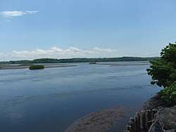
Lake Tōfutsu (濤沸湖 Tōfutsu-ko) is located in Abashiri and Koshimizu, Hokkaidō, Japan. It takes its name from the Ainu toputsu, or 'mouth of the lake'. A saline lagoon divided from the Sea of Okhotsk by sand dunes, Lake Tōfutsu provides an important habitat for wintering birds. In 2005 an area of 900 ha of wetlands was designated a Ramsar Site.[2]
See also
| Wikimedia Commons has media related to Lake Tofutsu. |
References
- ↑ "Tofutsu-ko". Ramsar Sites Information Service. Retrieved 25 April 2018.
- ↑ "Tofutsu-ko" (PDF). Ministry of the Environment. Retrieved 10 February 2012.
This article is issued from
Wikipedia.
The text is licensed under Creative Commons - Attribution - Sharealike.
Additional terms may apply for the media files.