Ross (lunar crater)
 Lunar Orbiter 4 image | |
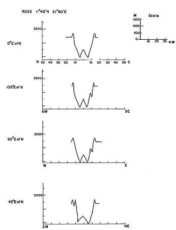
| Coordinates | 11°42′N 21°42′E / 11.7°N 21.7°ECoordinates: 11°42′N 21°42′E / 11.7°N 21.7°E |
|---|---|
| Diameter | 24 km |
| Depth | 1.8 km |
| Colongitude | 338° at sunrise |
| Eponym |
James C. Ross Frank E. Ross |
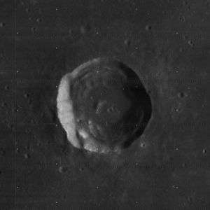
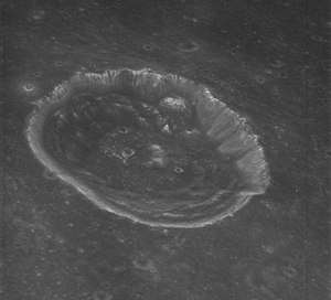
Ross is a lunar impact crater that is located in the northwest part of the Mare Tranquillitatis. It lies more than 90 km south-southwest of the crater Plinius, and more than 35 km northeast of the lava-flooded Maclear, also it is further east to the smaller Carrel crater. Further south is the faded crater known as Lamont located about 130 km south, the distance apart between Lamont and Ross craters of Mars is nearly the same with the two on the Moon.
This crater has a generally circular shape, but is not quite symmetrical. The inner walls slope down to a base of slumped material, before joining a relatively level interior floor. There is a low ridge to the west of the crater midpoint.
Names
The crater are named after both James Clark (British explorer) and Frank E. Ross (American explorer and optician). It was the location that earlier lunar cartographers had given the feature different names. Michael van Langren's 1645 map calls it "Fromondii" after a Fromond of the early 17th century.[1][2] And Johannes Hevelius called it "Apollonia Minor" of the ancient world.[3][4] When other lunar craters and other features were named by Giovanni Riccioli in 1651, the crater would be left unnamed for a few centuries.
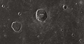
Satellite craters
By convention these features are identified on lunar maps by placing the letter on the side of the crater midpoint that is closest to Ross. Satellite craters B and C are in the northwest, D in the northeast, E, F and G in the southeast and H in the south.
| Ross | Latitude | Longitude | Diameter |
|---|---|---|---|
| B | 11.4° N | 20.2° E | 6 km |
| C | 11.7° N | 19.0° E | 5 km |
| D | 12.6° N | 23.3° E | 9 km |
| E | 11.1° N | 23.4° E | 4 km |
| F | 10.9° N | 24.2° E | 5 km |
| G | 10.7° N | 24.9° E | 5 km |
| H | 10.2° N | 21.8° E | 5 km |
Notes
- ↑ Ewen A. Whitaker, Mapping and Naming the Moon (Cambridge University Press, 1999).
- ↑ Langrenus map of the Moon (1645)
- ↑ Ewen A. Whitaker, Mapping and Naming the Moon (Cambridge University Press, 1999), p. 204.
- ↑ Hevelius map of the Moon (1647)
References
- Andersson, L. E.; Whitaker, E. A. (1982). NASA Catalogue of Lunar Nomenclature. NASA RP-1097.
- Blue, Jennifer (July 25, 2007). "Gazetteer of Planetary Nomenclature". USGS. Retrieved 2007-08-05.
- Bussey, B.; Spudis, P. (2004). The Clementine Atlas of the Moon. New York: Cambridge University Press. ISBN 978-0-521-81528-4.
- Cocks, Elijah E.; Cocks, Josiah C. (1995). Who's Who on the Moon: A Biographical Dictionary of Lunar Nomenclature. Tudor Publishers. ISBN 978-0-936389-27-1.
- McDowell, Jonathan (July 15, 2007). "Lunar Nomenclature". Jonathan's Space Report. Retrieved 2007-10-24.
- Menzel, D. H.; Minnaert, M.; Levin, B.; Dollfus, A.; Bell, B. (1971). "Report on Lunar Nomenclature by the Working Group of Commission 17 of the IAU". Space Science Reviews. 12 (2): 136–186. Bibcode:1971SSRv...12..136M. doi:10.1007/BF00171763.
- Moore, Patrick (2001). On the Moon. Sterling Publishing Co. ISBN 978-0-304-35469-6.
- Price, Fred W. (1988). The Moon Observer's Handbook. Cambridge University Press. ISBN 978-0-521-33500-3.
- Rükl, Antonín (1990). Atlas of the Moon. Kalmbach Books. ISBN 978-0-913135-17-4.
- Webb, Rev. T. W. (1962). Celestial Objects for Common Telescopes (6th revised ed.). Dover. ISBN 978-0-486-20917-3.
- Whitaker, Ewen A. (1999). Mapping and Naming the Moon. Cambridge University Press. ISBN 978-0-521-62248-6.
- Wlasuk, Peter T. (2000). Observing the Moon. Springer. ISBN 978-1-85233-193-1.
External links
- Ross at The Moon Wiki

- LTO-60B4 Ross — L&PI topographic map