Nelson County, Virginia
| Nelson County, Virginia | |
|---|---|
 | |
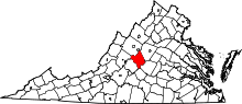 Location in the U.S. state of Virginia | |
 Virginia's location in the U.S. | |
| Founded | 1807 |
| Named for | Thomas Nelson, Jr. |
| Seat | Lovingston |
| Largest community | Nellysford |
| Area | |
| • Total | 474 sq mi (1,228 km2) |
| • Land | 471 sq mi (1,220 km2) |
| • Water | 3.5 sq mi (9 km2), 0.7% |
| Population (est.) | |
| • (2016) | 14,835 |
| • Density | 31/sq mi (12/km2) |
| Congressional district | 5th |
| Time zone | Eastern: UTC−5/−4 |
| Website |
www |
Nelson County is a county located in the Commonwealth of Virginia. As of the 2010 census, the population was 15,020.[1] Its county seat is Lovingston.[2]
Nelson County is part of the Charlottesville, VA Metropolitan Statistical Area.
Nelson County is home to Wintergreen Resort, a local ski area; Swannanoa mansion and is the location of Walton's Mountain made famous by the television show, The Waltons. Nelson County is also home to ten wineries, five craft breweries, two cideries, two distilleries, many fruit orchards and Crabtree Falls.
History
At the time the English began settling Virginia in the 1600s, the inhabitants of what is now Nelson County were a Siouan-speaking tribe called the Nahyssan. They were probably connected to the Manahoac.[3]
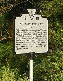
Nelson County was created in 1807 from Amherst County. The government was formed the following year.[4] The county is named for Thomas Nelson, Jr., a signer of the U.S. Declaration of Independence, who served as Governor of Virginia in 1781. An earlier Virginia county, also named in his honor, became part of Kentucky when it separated from Virginia in 1792.
Hurricane Camille
On the night of August 19–20, 1969, Nelson County was struck by disastrous flooding caused by Hurricane Camille. The hurricane hit the Gulf Coast two days earlier, weakened over land, and stalled on the eastern side of the Blue Ridge Mountains, dumping a world record quantity of 27 inches (690 mm) of rain, mainly in a three-hour period. Over five hours, it yielded more than 37 inches (940 mm), while the previous day had seen a deluge of 5 inches (130 mm) in half an hour, with the ground already saturated. There were reports of animals drowning in trees and people who had had to cup their hands around their mouth and nose to breathe.[5]
.jpg)
Flash floods and mudslides killed 153 people, 31 from Roseland, Tyro, and Massies Mill alone.[6] Over 133 public bridges were washed out in Nelson County, while some communities were under water.[7] In the tiny community of Davis Creek, 52 people were killed or could not be found; only 3 of 35 homes were left standing after the floodwaters receded.[6] The bodies of some people have never been found; others washed as much as 25 miles (40 km) downstream along the creeks and rivers. The entire county was virtually cut off, with many roads and virtually all bridges, telephone, radio/TV, and electric service interrupted.
The waters of the Tye, Piney, Buffalo, and Rockfish rivers flow into the James River. There was massive flooding elsewhere in Virginia, such as along the Maury River, which destroyed the town of Glasgow in Rockbridge County.
The James River and its tributaries normally drain Nelson County, but in the face of massive flooding from other tributaries such as Hatt Creek (along the James River some 80 miles (130 km) to the east) the James River crested more than 20 feet (6.1 m) above flood stage at Westham, as Nelson County citizens watched portions of houses and other buildings, bodies, and dead livestock flow past. Just a few miles further downstream, the James River crested at the City Locks in Richmond at 28.6 feet (8.7 m) swamping downtown areas and also flooding a substantial portion of South Richmond (formerly the separate city of Manchester.[8]). The Hurricane Camille disaster did over $140 million (in 1969 dollars) in damage across Virginia, however in no other place in Virginia was the storm as devastating and deadly as in Nelson County, where one percent of the population was killed and where many bodies were never recovered.
Geography
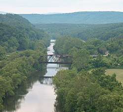
According to the U.S. Census Bureau, the county has a total area of 474 square miles (1,230 km2), of which 471 square miles (1,220 km2) is land and 3.5 square miles (9.1 km2) (0.7%) is water.[9] The Blue Ridge Mountains form the northwest boundary of the county; the James River forms the boundary to the southeast. Internally, Nelson consists of the Rockfish, Tye and Piney rivers, along with many known creeks.
Adjacent counties
- Augusta County – northwest
- Albemarle County – northeast
- Buckingham County – southeast
- Appomattox County – south
- Amherst County – southwest
- Rockbridge County – west
National protected areas
- Blue Ridge Parkway (part)
- George Washington National Forest (part)
- United States National Radio Quiet Zone (part)
Major highways
Education
Nelson County Public Schools is a Virginia public school division. It operates two elementary schools, one middle school, and one high school. The middle and high schools are connected and located just outside Lovingston, Virginia. Nelson County also provides free GED testing to all adults.
Jefferson-Madison Regional Library is the regional library system that provides services to the citizens of Nelson.
Demographics
| Historical population | |||
|---|---|---|---|
| Census | Pop. | %± | |
| 1810 | 9,684 | — | |
| 1820 | 10,137 | 4.7% | |
| 1830 | 11,254 | 11.0% | |
| 1840 | 12,287 | 9.2% | |
| 1850 | 12,758 | 3.8% | |
| 1860 | 13,015 | 2.0% | |
| 1870 | 13,898 | 6.8% | |
| 1880 | 16,536 | 19.0% | |
| 1890 | 15,336 | −7.3% | |
| 1900 | 16,075 | 4.8% | |
| 1910 | 16,821 | 4.6% | |
| 1920 | 17,277 | 2.7% | |
| 1930 | 16,345 | −5.4% | |
| 1940 | 16,241 | −0.6% | |
| 1950 | 14,042 | −13.5% | |
| 1960 | 12,752 | −9.2% | |
| 1970 | 11,702 | −8.2% | |
| 1980 | 12,204 | 4.3% | |
| 1990 | 12,778 | 4.7% | |
| 2000 | 14,445 | 13.0% | |
| 2010 | 15,020 | 4.0% | |
| Est. 2016 | 14,869 | [10] | −1.0% |
| U.S. Decennial Census[11] 1790-1960[12] 1900-1990[13] 1990-2000[14] 2010-2015[1] | |||
As of the census[15] of 2010, there were 15,020 people, 6,396 households, and 4,302 families residing in the county. The population density was 31.9 people per square mile (12/km²). There were 8,554 housing units at an average density of 18 per square mile (7/km²). The racial makeup of the county was 83.3% White, 13.1% Black or African American, 0.3% Native American, 0.5% Asian, Z% Pacific Islander, 1.1% from other races, and 1.7% from two or more races. Hispanic or Latino of any race were 3.1% of the population.
There were 6,396 households out of which 21.6% had children under the age of 18 living with them, 51.6% were married couples living together, 11.1% had a female householder with no husband present, and 32.7% were non-families. 27.4% of all households were made up of individuals and 11.1% had someone living alone who was 65 years of age or older. The average household size was 2.33 and the average family size was 2.81.
In the county, the population was spread out with 19.3% under the age of 18, 5.7% from 18 to 24, 25.5% from 25 to 44, 29.60% from 45 to 64, and 19.9% who were 65 years of age or older. The median age was 42.8 years. For every 100 females there were 95.2 males. For every 100 females age 18 and over, there were 93 males.
The median income for a household in the county was $48,118, and the median income for a family was $57,356. Males had a median income of $45,222 versus $34,842 for females. The per capita income for the county was $26,996. About 8.9% of families and 11.9% of the population were below the poverty line, including 13.8% of those under the age of 18 and 9.5% ages 65 or older.
Recreation

The Wintergreen Resort near Nellysford opened in 1975. A planned development begun in 1969, it offers 45 holes of championship golf; seasonal skiing, snowboarding and snowtubing. On the eastern slope of the Blue Ridge, Wintergreen is a "top down" resort in which practically all of the amenities are built on the peaks and ridges, rather than at the base like a traditional ski resort.[16]
Sections of the former Virginia Blue Ridge Railway along the Tye River are now part of the Blue Ridge Railway Trail, which was under development in the early 21st century. The trail will eventually connect the James River with the Blue Ridge Parkway and the Appalachian Trail.[17][18]
Fishing and camping are popular activities in Nelson County. Sections of the Tye River are also popular for whitewater boating with canoes and kayaks. The rapids are rated Class I to Class II+. Depending upon water conditions some rapids on the Tye River can approach class III.[19]
The first annual Lockn' Music Festival was held September 5–8, 2013 on a farm in Nelson County near Arrington, Virginia.[20]
Camp Jeep was held at the Oak Ridge Estate in Arrington for several years beginning in 1999 with the last event taking place in 2007.[21]
Communities
There are no cities or incorporated towns in Nelson County. It consists of unincorporated communities including census-designated places (CDPs).
Municipalities and communities of Nelson County, Virginia, United States | ||
|---|---|---|
| CDPs | | |
| Unincorporated communities |
| |
| Footnotes | ‡This populated place also has portions in an adjacent county or counties | |
Notable people
- DeLane Fitzgerald, college football coach, and current head football coach at Frostburg State University.
- Walter Loving, commander of the Philippine Constabulary Band and the first African-American to direct a musical performance at the White House.
- L.A. Snead, former US Assistant Fuel Administrator (WWI), environmentalist and notable Nelsonian, spearheaded negotiations to secure land surrounding Crabtree Falls after it was almost developed as a resort area in the late 1960s Using personal and Congressional funds, the land deals were completed and the deeds transferred by LA Snead on June 3, 1968, to the National Forest System. This assured benefit for future generations of this magnificent Nelson County treasure.
- Edward Coles, secretary to James Madison and second governor of Illinois, inherited Rockfish plantation in Nelson County and in June 1819 manumitted (freed) the slaves he brought from that plantation on the Ohio River near Pittsburgh, Pennsylvania on their joint way to the Illinois Territory.
- Eli Cook, blues singer, songwriter, guitarist and record producer,[22] who has released six albums before his 30th birthday.[23]
- Jimmy Fortune, former tenor for the Statler Brothers, and member of the Gospel and Country Music Hall of Fame
- Reverend Dr. William Archer Rutherfoord Goodwin grew up on farm in southern Nelson County during the Reconstruction era after the American Civil War. An Episcopalian priest, among other assignments, he served several periods as rector of Bruton Parish Church in Williamsburg. It was Dr. Goodwin's dream, and his success in gaining the generous support of Mr. & Mrs. John D. Rockefeller Jr., that created Colonial Williamsburg beginning in 1926.
- Schuyler was the birthplace and childhood home of writer Earl Hamner Jr. He is best known for the CBS television series The Waltons, which was based on his experiences of growing up the eldest child of a large rural family in depression era America. Earl and many members of his family attended Schuyler Baptist Church, which is still active in the community.
- Thomas Bland Harvey, Sr. attended the Inauguration of U.S. President Woodrow Wilson at the President's personal invitation and sat in the front row at Washington, D.C. Harvey founded the first Dodge Brothers Dealership in the World. He built many buildings in Roseland, Virginia by hand, including the United States Post Office where his wife Marion Belle-Bowles-Harvey was the Postmaster. Harvey was s trusted Virginian gentleman whose family descended from the original settlers at Jamestown and traveled on two of the three ships landing there May 14, 1607. He was a 32nd Degree Mason / Shriner. A seventeen plus foot wave of water in the aftermath of Hurricane Camille destroyed his house and contents, as well as washed them into the US Post Office, which was likewise destroyed. A safe was later found over five miles down the Tye River. Newspapers quoted Harvey after the flood as saying, "It is God's will!."
- William Porcher Miles, South Carolina born States Rights advocate and former U.S. and Confederate congressman, briefly managed Oak Ridge plantation near Lovingston after the Civil War for his wife's father before moving to Louisiana.
- Robert Monroe, an out-of-body experience researcher who founded the Monroe Institute, lived in Faber.
- William Rives, tobacco magnate, built Oak Ridge plantation near Lovingston.
- Thomas Fortune Ryan, born near Lovingston before the Civil War as the son of a tailor who managed a small hotel, bought Oak Ridge plantation after becoming rich in New York City by consolidating transportation and tobacco companies (among others).
- Dr. Gessner Harrison in 1860 established Locust Grove Academy, a boarding school for boys in the northernmost part of the county, and enrolled 100 students. Soon thereafter, his efforts were thwarted, when most of the students left the school to join the Confederate Army.
Politics
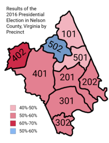
| Year | Republican | Democratic | Third parties |
|---|---|---|---|
| 2016 | 50.0% 4,154 | 44.4% 3,689 | 5.6% 468 |
| 2012 | 47.8% 3,947 | 50.6% 4,171 | 1.6% 132 |
| 2008 | 44.8% 3,647 | 54.0% 4,391 | 1.2% 95 |
| 2004 | 49.6% 3,539 | 49.6% 3,543 | 0.8% 57 |
| 2000 | 47.4% 2,913 | 47.3% 2,907 | 5.3% 325 |
| 1996 | 37.8% 1,988 | 52.9% 2,782 | 9.4% 494 |
| 1992 | 39.0% 2,159 | 46.7% 2,586 | 14.3% 793 |
| 1988 | 51.6% 2,502 | 46.9% 2,272 | 1.6% 75 |
| 1984 | 57.2% 2,777 | 41.6% 2,021 | 1.1% 55 |
| 1980 | 41.5% 1,866 | 53.6% 2,410 | 4.9% 220 |
| 1976 | 37.7% 1,516 | 60.2% 2,426 | 2.1% 85 |
| 1972 | 67.2% 2,145 | 29.9% 954 | 2.9% 92 |
| 1968 | 33.0% 1,130 | 32.7% 1,120 | 34.3% 1,176 |
| 1964 | 35.2% 893 | 64.5% 1,635 | 0.2% 6 |
| 1960 | 34.2% 775 | 65.3% 1,480 | 0.6% 13 |
| 1956 | 37.2% 764 | 59.2% 1,215 | 3.7% 75 |
| 1952 | 37.6% 740 | 62.0% 1,222 | 0.4% 8 |
| 1948 | 21.3% 371 | 69.2% 1,204 | 9.5% 166 |
| 1944 | 23.5% 427 | 76.4% 1,390 | 0.1% 2 |
| 1940 | 20.3% 330 | 79.4% 1,291 | 0.3% 5 |
| 1936 | 23.5% 370 | 76.4% 1,204 | 0.2% 3 |
| 1932 | 14.0% 238 | 85.6% 1,457 | 0.4% 7 |
| 1928 | 33.7% 618 | 66.3% 1,216 | |
| 1924 | 24.5% 350 | 72.8% 1,042 | 2.7% 39 |
| 1920 | 28.7% 392 | 71.2% 973 | 0.2% 2 |
| 1916 | 19.0% 249 | 81.0% 1,063 | |
| 1912 | 16.8% 163 | 72.7% 706 | 10.5% 102 |
See also
References
- 1 2 "State & County QuickFacts". United States Census Bureau. Retrieved January 4, 2014.
- ↑ "Find a County". National Association of Counties. Retrieved 2011-06-07.
- ↑ Swanton, John R. (1952), The Indian Tribes of North America, Smithsonian Institution, p. 64, ISBN 0-8063-1730-2, OCLC 52230544
- ↑ Archived July 6, 2008, at the Wayback Machine.
- ↑ Provence, Lisa (20 August 2009). "Cataclysmic Camille: After 40 years, Nelson County's wounds still fresh". The Hook. Retrieved 31 July 2017.
- 1 2 Archived May 18, 2006, at the Wayback Machine.
- ↑ United States Department of Commerce (1969). "Hurricane Camille August 14–22, 1969" (PDF). Environmental Science Services Administration. Retrieved March 23, 2008.
- ↑ Archived December 4, 2008, at the Wayback Machine.
- ↑ "US Gazetteer files: 2010, 2000, and 1990". United States Census Bureau. 2011-02-12. Retrieved 2011-04-23.
- ↑ "Population and Housing Unit Estimates". Retrieved June 9, 2017.
- ↑ "U.S. Decennial Census". United States Census Bureau. Retrieved January 4, 2014.
- ↑ "Historical Census Browser". University of Virginia Library. Retrieved January 4, 2014.
- ↑ "Population of Counties by Decennial Census: 1900 to 1990". United States Census Bureau. Retrieved January 4, 2014.
- ↑ "Census 2000 PHC-T-4. Ranking Tables for Counties: 1990 and 2000" (PDF). United States Census Bureau. Retrieved January 4, 2014.
- ↑ "American FactFinder". United States Census Bureau. Retrieved 2011-05-14.
- ↑ "Wintergreen Resort, Premier Blue Ridge Mountain Virginia Vacation and Ski Resort". Wintergreenresort.com. Retrieved 2016-01-04.
- ↑ Archived January 19, 2008, at the Wayback Machine.
- ↑ "Virginia Short Lines and Industrial Roads". Donsdepot.donrossgroup.net. Retrieved 2016-01-04.
- ↑ "Nelson Downriver Race - 2005". Nelsoncountyva.org. 2005-04-30. Retrieved 2016-01-04.
- ↑ Greene, Andy. "Interlocken Festival Unites Neil Young, Furthur and Widespread Panic". Rolling Stone. Retrieved September 10, 2013.
- ↑ Lindsey Ward (July 25, 2007). "Camp Jeep Rolls into Nelson County". Newsplex.com. Archived from the original on March 4, 2014. Retrieved January 4, 2016.
- ↑ "Eli Cook". ReverbNation.com. Retrieved 2016-01-04.
- ↑ "Eli Cook | Album Discography". AllMusic. Retrieved 2016-01-04.
- ↑ Leip, David. "Dave Leip's Atlas of U.S. Presidential Elections". uselectionatlas.org.
External links
| Wikimedia Commons has media related to Nelson County, Virginia. |
Places adjacent to Nelson County, Virginia | ||||||||||
|---|---|---|---|---|---|---|---|---|---|---|
| ||||||||||
Municipalities and communities of Nelson County, Virginia, United States | ||
|---|---|---|
| CDPs | | |
| Unincorporated communities |
| |
| Footnotes | ‡This populated place also has portions in an adjacent county or counties | |
