Pulaski County, Virginia
| Pulaski County, Virginia | ||
|---|---|---|
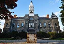 Pulaski County Courthouse | ||
| ||
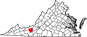 Location in the U.S. state of Virginia | ||
 Virginia's location in the U.S. | ||
| Founded | 1839 | |
| Named for | Casimir Pulaski | |
| Seat | Pulaski | |
| Largest town | Pulaski | |
| Area | ||
| • Total | 330 sq mi (855 km2) | |
| • Land | 320 sq mi (829 km2) | |
| • Water | 10 sq mi (26 km2), 3.0% | |
| Population (est.) | ||
| • (2015) | 34,332 | |
| • Density | 104/sq mi (40/km2) | |
| Congressional district | 9th | |
| Time zone | Eastern: UTC−5/−4 | |
| Website |
www | |

Pulaski County is a county located in the U.S. state of Virginia. As of the 2010 census, the population was 34,872.[1] Its county seat is Pulaski.[2]
Pulaski County is part of the Blacksburg–Christiansburg–Radford, VA Metropolitan Statistical Area.
History
Pulaski County was formed on March 30, 1839, from parts of Montgomery and Wythe counties, becoming the 87th county of the Commonwealth of Virginia. It was named for Count Casimir Pulaski, an exiled Polish nobleman who fought during the American Revolution as part of George Washington's army. He joined the army in 1777 and became a brigadier general and chief of cavalry in the Continental Army. He was fatally wounded at Savannah and died on October 11, 1779.[3]
This area of the Blue Ridge has rolling hills and was settled by mostly small farmers, recent Scots-Irish and German immigrants and their descendants who migrated down the Shenandoah Valley from Pennsylvania in the mid to late-18th century. They pushed out or killed most Native Americans in the area. The new settlers were yeomen, who held fewer slaves than in the Tidewater area. Nonetheless, by 1840 about one-quarter of the population was made up of enslaved African Americans. The county had 3,739 persons, consisting of 2,768 free whites, and 971 blacks. Some 17 of the latter were free blacks.
Geography
According to the U.S. Census Bureau, the county has a total area of 330 square miles (850 km2), of which 320 square miles (830 km2) is land and 10 square miles (26 km2) (3.0%) is water.
Pulaski County is the site of Claytor Lake State Park, which is located on Claytor Lake, a 4,500-acre (18 km2), 21-mile (34 km) long man-made lake on the New River created for a hydroelectric project of Appalachian Power Company. It is named for W. Graham Claytor, Sr. (1886–1971) of Roanoke, Virginia, a vice president of Appalachian Power who supervised construction of the dam and creation of the lake.
Adjacent counties / Independent city
- Bland County, Virginia – northwest
- Giles County, Virginia – north
- Montgomery County, Virginia – northeast
- Radford, Virginia – northeast
- Floyd County, Virginia – southeast
- Carroll County, Virginia – south
- Wythe County, Virginia – southwest
National protected area
- Jefferson National Forest (part)
Major highways
Demographics
| Historical population | |||
|---|---|---|---|
| Census | Pop. | %± | |
| 1840 | 3,739 | — | |
| 1850 | 5,118 | 36.9% | |
| 1860 | 5,416 | 5.8% | |
| 1870 | 6,538 | 20.7% | |
| 1880 | 8,755 | 33.9% | |
| 1890 | 12,790 | 46.1% | |
| 1900 | 14,609 | 14.2% | |
| 1910 | 17,246 | 18.1% | |
| 1920 | 17,111 | −0.8% | |
| 1930 | 20,566 | 20.2% | |
| 1940 | 22,767 | 10.7% | |
| 1950 | 27,758 | 21.9% | |
| 1960 | 27,258 | −1.8% | |
| 1970 | 29,564 | 8.5% | |
| 1980 | 35,229 | 19.2% | |
| 1990 | 34,496 | −2.1% | |
| 2000 | 35,127 | 1.8% | |
| 2010 | 34,872 | −0.7% | |
| Est. 2016 | 34,203 | [4] | −1.9% |
| U.S. Decennial Census[5] 1790–1960[6] 1900–1990[7] 1990–2000[8] 2010–2013[1] | |||
As of the census[9] of 2000, there were 35,127 people, 14,643 households, and 10,147 families residing in the county. The population density was 110 people per square mile (42/km²). There were 16,325 housing units at an average density of 51 per square mile (20/km²). The racial makeup of the county was 92.60% White, 5.57% Black or African American, 0.15% Native American, 0.32% Asian, 0.04% Pacific Islander, 0.37% from other races, and 0.94% from two or more races. 0.96% of the population were Hispanic or Latino of any race.
There were 14,643 households out of which 26.90% had children under the age of 18 living with them, 54.90% were married couples living together, 10.50% had a female householder with no husband present, and 30.70% were non-families. 27.00% of all households were made up of individuals and 11.10% had someone living alone who was 65 years of age or older. The average household size was 2.32 and the average family size was 2.80.
In the county, the population was spread out with 20.60% under the age of 18, 7.30% from 18 to 24, 29.20% from 25 to 44, 27.70% from 45 to 64, and 15.20% who were 65 years of age or older. The median age was 40 years. For every 100 females, there were 97.40 males. For every 100 females age 18 and over, there were 95.20 males.
The median income for a household in the county was $33,873, and the median income for a family was $42,251. Males had a median income of $30,712 versus $21,596 for females. The per capita income for the county was $18,973. About 10.60% of families and 13.10% of the population were below the poverty line, including 18.90% of those under age 18 and 11.50% of those age 65 or over.
Schools
New River Community College;
Pulaski County High School;
Pulaski Middle School;
Dublin Middle School;
Pulaski Elementary School;
Dublin Elementary School;
Critzer Elementary School;
Riverlawn Elementary School;
Snowville Elementary School;
Communities
Towns
Census-designated places
Other unincorporated communities
- Caseknife
- Claytor Lake
- Newbern
- Wurno
- Little Creek
- Delton, Virginia
- Tiny Town, Virginia
Politics
| Year | Republican | Democratic | Third parties |
|---|---|---|---|
| 2016 | 68.1% 10,322 | 27.5% 4,172 | 4.4% 671 |
| 2012 | 60.8% 8,920 | 36.1% 5,292 | 3.2% 468 |
| 2008 | 58.9% 8,857 | 39.3% 5,918 | 1.8% 275 |
| 2004 | 61.5% 8,769 | 37.3% 5,310 | 1.2% 172 |
| 2000 | 55.8% 7,089 | 41.4% 5,255 | 2.8% 353 |
| 1996 | 43.8% 5,387 | 43.3% 5,333 | 12.9% 1,584 |
| 1992 | 44.0% 6,148 | 40.3% 5,633 | 15.8% 2,206 |
| 1988 | 58.4% 6,844 | 40.0% 4,686 | 1.6% 189 |
| 1984 | 64.9% 8,242 | 34.4% 4,364 | 0.7% 93 |
| 1980 | 47.7% 5,747 | 47.9% 5,769 | 4.4% 524 |
| 1976 | 44.8% 4,764 | 52.2% 5,546 | 3.0% 314 |
| 1972 | 72.0% 6,281 | 26.5% 2,311 | 1.5% 130 |
| 1968 | 53.4% 4,409 | 30.2% 2,497 | 16.5% 1,359 |
| 1964 | 46.1% 3,101 | 53.8% 3,620 | 0.1% 5 |
| 1960 | 58.8% 3,059 | 40.4% 2,104 | 0.9% 44 |
| 1956 | 63.1% 3,517 | 35.8% 1,994 | 1.2% 67 |
| 1952 | 62.0% 2,815 | 37.8% 1,715 | 0.2% 8 |
| 1948 | 49.0% 1,691 | 40.9% 1,412 | 10.1% 349 |
| 1944 | 37.7% 1,302 | 62.3% 2,155 | 0.0% 1 |
| 1940 | 31.4% 1,023 | 68.4% 2,226 | 0.2% 6 |
| 1936 | 33.5% 1,180 | 66.4% 2,337 | 0.1% 4 |
| 1932 | 32.1% 1,109 | 67.0% 2,314 | 0.9% 31 |
| 1928 | 52.3% 1,998 | 47.7% 1,821 | |
| 1924 | 43.3% 1,422 | 53.8% 1,767 | 2.8% 93 |
| 1920 | 48.4% 1,710 | 51.4% 1,814 | 0.2% 7 |
| 1916 | 38.7% 721 | 56.7% 1,057 | 4.6% 86 |
| 1912 | 13.3% 196 | 52.9% 781 | 33.9% 500 |
Pulaski County Men in State Government
James Alexander Walker, Brigadier General, CSA, [11]experienced a political life as colorful and exciting as his four years of distinguished service in the defense of his State. He had the honor of being the only one of the five Walkers who wore the epaulets of a Brigadier or Major General to be present at Appomattox on Sunday, April 9, 1865. He was a graduate of Virginia Military Institute and the University of Virginia. In 1856 he began the practice of law in Pulaski, and was shortly chosen Commonwealth Attorney, which office he was filling most creditably when Virginia called for her able sons to defend the State from invasion. He was chosen Captain of the Pulaski Guards, which was mustered into service as a unit of the Stonewall brigade[12]. His promotions were rapid, becoming the Colonel of the Stonewall Brigade, and later successor to Brigadier Generals Jubal Anderson Early [13] and Richard Stoddard Ewell [14] the latter having been captured and made prisoner. On Walker's return to Pulaski, he was chosen as a member of the House of Delegates for the 1871-1872 session. He was elected Lieutenant Governor for the four year term 1878-1882. He remained an ardent Democrat until 1893, when he became a rampant Republican and was elected to Congress for two terms from 1895-1899. General Walker was the orator at the unveiling of the monument to General Ambrose Powell (A.P.) Hill[15], May 30, 1892, at Richmond, VA. General Hill's remains rest under that monument.[16] General Walker died at Wytheville, VA, October 21, 1901.[17]
James Hoge Tyler was the only private, and the last Confederate Veteran with four years service on the Confederate Army to become the Chief Executive of the State. Born in Caroline County, VA August 11, 1846, his parents were George Tyler and his second wife Elizabeth Hoge. Eliza died 2 hours after James' birth, and his maternal grandparents brought him the 300 miles back to Pulaski County and reared him here. His grandparents were General James F. Hoge and Eleanor Haven Howe, and they owned what is now known as Belle-Hampton estate. James lived with his grandparents until he enlisted in the Confederate Army in 1861, and served until the end of the war, when he was paroled at Appomattox. After the war, he returned to Pulaski to farm, and became interested in politics. In 1877 he was chosen as Senator for the counties of Pulaski, Bland, Giles, and Tazewell, and presided as President of the Senate. He was chosen as Lieutenant Governor on the Democratic ticket in 1889, and served that office from 1890-1894. In 1897 he was elected Governor, and served from 1898-1902. He was successful in securing legislation that resulted in the creation of the Bureau of Labor, the conditional pardon system, a revamping of the Department of Agriculture, and the construction of additional buildings at Virginia Polytechnic Institute and Southwestern State Hospital. One of his greatest accomplishments was his call on April 25, 1898 for Virginians to volunteer for service in the Spanish American War. Several thousand responded, and were encamped at Camp Lee, VA. [18][19] In the 1940's the Governor Tyler Hotel was opened in Radford, VA, in honor of James Hoge Tyler, and was a grand hotel with several dining halls and a ballroom.[20] James Hoge Tyler died January 3, 1925, and is buried in the West View Cemetery in Radford, VA.[21]
See also
References
- 1 2 "State & County QuickFacts". United States Census Bureau. Retrieved January 4, 2014.
- ↑ "Find a County". National Association of Counties. Retrieved 2011-06-07.
- ↑ History of Pulaski County (PDF)
- ↑ "Population and Housing Unit Estimates". Retrieved June 9, 2017.
- ↑ "U.S. Decennial Census". United States Census Bureau. Retrieved January 4, 2014.
- ↑ "Historical Census Browser". University of Virginia Library. Retrieved January 4, 2014.
- ↑ "Population of Counties by Decennial Census: 1900 to 1990". United States Census Bureau. Retrieved January 4, 2014.
- ↑ "Census 2000 PHC-T-4. Ranking Tables for Counties: 1990 and 2000" (PDF). United States Census Bureau. Retrieved January 4, 2014.
- ↑ "American FactFinder". United States Census Bureau. Retrieved 2011-05-14.
- ↑ Leip, David. "Dave Leip's Atlas of U.S. Presidential Elections". uselectionatlas.org. Retrieved 2018-08-22.
- ↑ "James A. Walker".
- ↑ "Stonewall Brigade".
- ↑ "Jubal Early".
- ↑ "Richard S. Ewell".
- ↑ "A.P. Hill".
- ↑ Rogers, George Wesley (1959). Officers of the Senate of Virginia 1776-1956. Library of Congress Catalog Card Number 59-12727: Garrett & Massie, Inc. p. 57.
- ↑ "Findagrave Memorial". Findagrave.com.
- ↑ Rogers, George Wesley (1959). Officers of the Senate of Virginia. Library of Congress Catalog Number 59-12727: Garrett & Massie, Inc. p. 61.
- ↑ "James Hoge Tyler".
- ↑ "Governor Tyler Hotel".
- ↑ "Findagrave". Findagrave.com.
External links
- Claytor Lake Online Website
- Pulaski County, Virginia official website
- Claytor Lake State Park (Virginia)
- Virginia Dept. of Game and Inland Fisheries, Claytor Lake webpage
Places adjacent to Pulaski County, Virginia | ||||||||||
|---|---|---|---|---|---|---|---|---|---|---|
| ||||||||||
Municipalities and communities of Pulaski County, Virginia, United States | ||
|---|---|---|
| Towns | | |
| CDPs | ||
| Unincorporated communities | ||
