Manassas, Virginia
| Manassas, Virginia | |||
|---|---|---|---|
| Independent city | |||
| City of Manassas | |||
 View of downtown Manassas looking east on Center Street. | |||
| |||
 Manassas  Manassas  Manassas | |||
| Coordinates: 38°45′5″N 77°28′35″W / 38.75139°N 77.47639°WCoordinates: 38°45′5″N 77°28′35″W / 38.75139°N 77.47639°W | |||
| Country |
| ||
| State |
| ||
| County | None (Independent city) | ||
| Government | |||
| • Type | Council-Manager | ||
| • Mayor | Harry J. (Hal) Parrish II | ||
| • City Manager | W. Patrick Pate | ||
| • Vice Mayor | Marc Aveni | ||
| • City Council |
Council Members
| ||
| Area | |||
| • Total | 26 km2 (9.9 sq mi) | ||
| • Land | 26 km2 (9.9 sq mi) | ||
| • Water | 0.3 km2 (0.1 sq mi) | ||
| Elevation | 93 m (305 ft) | ||
| Population (2017) | |||
| • Total | 41,501 | ||
| • Density | 1,619/km2 (4,192/sq mi) | ||
| Time zone | UTC−5 (EST) | ||
| • Summer (DST) | UTC−4 (EDT) | ||
| ZIP codes | 20108 (PO Box Only), and 20110[1] | ||
| Area code(s) | 703, 571 | ||
| FIPS code | 51-48952[2] | ||
| GNIS feature ID | 1498512[3] | ||
| Website | ManassasCity.org | ||

Manassas (formerly Manassas Junction)[4] is an independent city in the Commonwealth of Virginia. As of the 2010 Census, the population was 37,821.[5] The city borders Prince William County, and the independent city of Manassas Park, Virginia. The Bureau of Economic Analysis includes both Manassas and Manassas Park with Prince William County for statistical purposes.
Manassas also serves as the seat of Prince William County. It surrounds the 38-acre (150,000 m2) county courthouse, but that county property is not part of the city. The City of Manassas has several important historic sites from the period 1850–1870.
The City of Manassas is part of the Washington-Arlington-Alexandria, DC-VA-MD-WV Metropolitan Statistical Area and it is situated in the Northern Virginia region.
History
In July 1861, the First Battle of Manassas – also known as the First Battle of Bull Run – the first major land battle of the American Civil War, was fought nearby. Manassas commemorated the 150th anniversary of the First Battle of Manassas during July 21–24, 2011.[6]
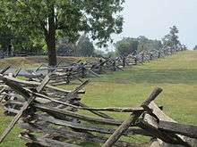
The Second Battle of Manassas (or the Second Battle of Bull Run) was fought near Manassas during August 28–30, 1862. At that time, Manassas Junction was little more than a railroad crossing, but a strategic one, with rails leading to Richmond, Virginia, Washington, D.C., and the Shenandoah Valley. Despite these two Confederate victories, Manassas Junction was in Union hands for most of the war.
Following the war, the crossroads grew into the town of Manassas, which was incorporated in 1873. In 1894, Manassas was designated as the county seat of Prince William County, Virginia, replacing Brentsville. In 1975, Manassas was incorporated as an independent city, and as per Virginia law, was separated from Prince William County.
The Manassas Historic District, Cannon Branch Fort, Liberia, a plantation house; and the Manassas Industrial School for Colored Youth are listed on the National Register of Historic Places.[7]
Geography
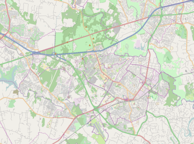
Manassas is mainly served by I-66, U.S. 29, Virginia State Route 234 Business and Virginia State Route 28.
According to the United States Census Bureau, the city has a total area of 9.9 square miles (25.6 km2), of which 9.9 square miles (25.6 km2) is land and 0.1 square miles (0.3 km2) (0.5%) is water.[8]
Manassas uses a council-manager system of government. The current city manager is William Patrick Pate. The current mayor is Harry J. Parrish II. The current vice mayor is Marc Aveni.
Climate
The climate in this area is characterized by hot, humid summers and generally mild to cool winters. According to the Köppen Climate Classification system, Manassas has a humid subtropical climate, abbreviated "Cfa" on climate maps.[9]
Adjacent counties and independent cities
- Prince William County, Virginia – northwest, west, south, east
- Manassas Park, Virginia – northeast
Demographics
| Historical population | |||
|---|---|---|---|
| Census | Pop. | %± | |
| 1880 | 361 | — | |
| 1890 | 530 | 46.8% | |
| 1900 | 817 | 54.2% | |
| 1910 | 1,217 | 49.0% | |
| 1920 | 1,305 | 7.2% | |
| 1930 | 1,215 | −6.9% | |
| 1940 | 1,302 | 7.2% | |
| 1950 | 1,804 | 38.6% | |
| 1960 | 3,555 | 97.1% | |
| 1970 | 9,164 | 157.8% | |
| 1980 | 15,438 | 68.5% | |
| 1990 | 27,957 | 81.1% | |
| 2000 | 35,135 | 25.7% | |
| 2010 | 37,821 | 7.6% | |
| Est. 2017 | 41,501 | [10] | 9.7% |
| U.S. Decennial Census[11] 1790-1960[12] 1900-1990[13] 1990-2000[14] | |||
According to the census[15] of 2010, the population of the City of Manassas was 37,821 which represented a 7.6% growth in population since the last census in 2000. As of July, 2011, the City’s population is estimated at 39,060.[16] The City is culturally diverse; the 2010 Census reports that 21.4% of the population is Hispanic. The racial breakdown per the 2010 Census for the City is as follows:
- 61.7% White
- 15.7% Black
- 4.9% Asian
- 14.6% Other
The population density for the city is 3,782.1 people per square mile and there are an estimated 13,103 housing units in the city with an average housing density of 1,310.3 per square mile.[17] The greatest percentage of housing values of owner-occupied homes (34.8%) is $300,000 to $499,999, with a median owner-occupied housing value of $259,100. The City’s highest period of growth was from 1980 to 1989, when 35% of the City’s housing stock was constructed.[18]
The ACS estimated median household income for the City in 2010 was $70,211. 36% of the population has a college degree.[17] Almost as many people commute into the City of Manassas for work (13,316) as out (13,666), with the majority of out commuters traveling to Fairfax and Prince William counties for their jobs. Unemployment as of July, 2010 in the City is 6.3%, which was well below that of the United States at 7.9%. City residents are primarily employed in Professional, Scientific and Technical Services, and Health Care and Social Assistance.[19]
Politics
| Year | Republican | Democratic | Third Parties |
|---|---|---|---|
| 2016 | 38.6% 5,953 | 54.7% 8,423 | 6.7% 1,035 |
| 2012 | 42.5% 6,463 | 55.8% 8,478 | 1.9% 259 |
| 2008 | 43.8% 5,975 | 55.2% 7,518 | 1.0% 134 |
| 2004 | 56.2% 7,257 | 43.1% 5,562 | 0.7% 84 |
| 2000 | 54.4% 6,752 | 42.4% 5,262 | 3.2% 396 |
| 1996 | 52.9% 5,799 | 39.9% 4,378 | 7.1% 783 |
| 1992 | 48.9% 5,453 | 32.7% 3,647 | 18.4% 2,054 |
| 1988 | 68.6% 5,980 | 30.5% 2,658 | 0.9% 81 |
| 1984 | 71.3% 4,613 | 28.2% 1,824 | 0.4% 29 |
| 1980 | 60.8% 3,009 | 31.6% 1,565 | 7.6% 378 |
| 1976 | 53.3% 1,992 | 44.0% 1,646 | 2.6% 99 |
Crime
During the second quarter of 2014, crime in the City of Manassas has decreased by 9 percent.[21] Calls for service from residents have decreased 27 percent from 2013 to 2014. Overall crime in the City of Manassas has steadily decreased over the years, as it has nationwide. About 1 in 5 reports taken during the 2nd quarter of 2014 was for a part 1 crime. The number of aggravated assaults reported in 2014 year-to-date and during the second quarter has increased by about half when compared to 2013 cases (+46%, +64%, respectively). Part 1 property crimes decreased by 19 cases during the 2nd quarter of 2014 (burglary, larceny, and auto theft). Overall, year-to-date totals indicate decreases in part 1 crimes (-14%) and all other offenses reported to police (-9%).[21]
Crime in Manassas has been rated by Neighborhood Scout to be more dangerous than 63% of all American neighborhoods and 37% safer than all American neighborhoods. That shows that Manassas has a moderately higher crime rate than average.[22] The website SiteJabber had numerous reviews that said Neighborhood Scout was an unreliable business that promoted poor practices and did not have accurate crime reports. From a total of eleven reviews, Neighborhood Scout was ranked at 1.5 stars, out of 5.[23]
Economy
The Manassas Regional Airport has 26 businesses operating out of the airport property. There are 415 based airplanes and two fixed-base operators, APP Jet Center and Dulles Aviation. The Manassas Regional Airport has land available for development.[24]
The city's third-largest employer is Micron Technology. Headquartered in Boise, Idaho, this manufacturer of semiconductors operates its wafer factory in Manassas, where it employs 1650 people directly, and several hundred others through vendor contracts. Other major employers include Lockheed Martin (1500 employees) and the Novant Prince William Health System (1400 employees).
11% of people working in Manassas live in the city, while 89% commute in. 36% commute from Prince William County and 18% commute from Fairfax. Additionally 16,700 people commute from Manassas to the surrounding areas. In 2016, 3.3% of Manassas residents were unemployed.[25]
Transportation
Major highways
The major roads into and out of Manassas are VA-28 and VA-234 Business. I-66 and US-29 service Manassas, but neither passes through the city itself.
Airports
Manassas Regional Airport is located within the city limits. The Manassas Regional Airport is the busiest general aviation airport in the Commonwealth of Virginia with more than 415 based aircraft and 26 businesses based onsite ranging from charter companies, avionics, maintenance, flight schools and aircraft services.
Rail transportation
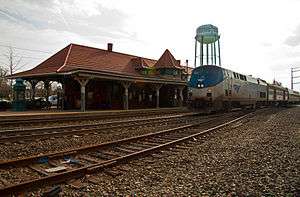
Manassas began life as Manassas Junction, so named for the railroad junction between the Orange and Alexandria Railroad and the Manassas Gap Railroad. The O&A owned the railway from Alexandria through Manassas to points south, ending in Orange, Virginia, while the MGRR was an independent line constructed from Manassas Junction through the Manassas Gap westward. In addition Manassas was the site of the first large scale military use of railroad transportation.
These original routes are now owned by the Norfolk Southern railroad. Amtrak and the Virginia Railway Express (VRE) provide both regular and commuter service to the city and surrounding area on the tracks owned by NS. Three Amtrak routes, the Cardinal, the Northeast Regional and Crescent, provide service. The Cardinal terminates in Chicago, the Northeast Regional in Boston, while the Crescent ends at New Orleans. VRE is a very popular commuting option to Alexandria and Washington, D.C.. VRE has two stops located in the City of Manassas, one in downtown Manassas and one at the Manassas Regional Airport.
The train station was also used for the cover photo for the Manassas (album).
Education
The City of Manassas is served by the Manassas City Public Schools. The School Superintendent is Dr. Catherine Magouyrk. There are five elementary schools in Manassas, two intermediate school, one middle school, and one high school. In 2006, Mayfield Intermediate School opened, serving students in fifth and sixth grade. Due to growth, Baldwin Intermediate School opened in September 2017, also serving 5th and 6th graders.
Some schools in the Prince William County Public Schools district have Manassas addresses, though they are located, and serve areas, outside the Manassas city limits.
Seton School, a private Roman Catholic junior and senior high school affiliated with the Diocese of Arlington, provides Catholic education from its Manassas location.[26] The All Saints Catholic School at the All Saints Parish provides Catholic Education from pre-K through 8th grade. The All Saints Catholic School was a Presidential Blue Ribbon Award winner in 2009.[27]
Also in the vicinity of Manassas are branch campuses of American Public University System, George Mason University, Northern Virginia Community College, ECPI College of Technology and Strayer University. Despite that some of these may in fact be just outside the city limits in Prince William County, NVCC and Strayer call these branches their "Manassas Campuses."
Public schools in Manassas:[28]
Notable people
- Jim Bucher (1911–2004), infielder and outfielder in Major League Baseball
- Ryan Burroughs, professional rugby league footballer currently playing for Toronto Wolfpack
- Danny Doyle, Irish folk singer.[38]
- Wilmer Fields, pitcher and third baseman in Negro league baseball
- Brandon Hogan, football player
- Chaney Kley (1972–2007), American film and television actor
- Jon Knott, Major League Baseball outfielder
- Jeremy Linn, 1996 Summer Olympics swimmer and current swimming coach
- Mike O'Meara, radio personality[39][40][41]
- Harry J. Parrish (1922–2006), longtime member of the Virginia House of Delegates
- Leven Powell, also Levin, (1737–1810), U.S. Representative from Virginia
- Jason Richardson, American guitarist
- David Robinson, American basketball player
- Danica Roem, the first ever openly transgender woman to be elected to a US legislature
- Ravi Shankar, American poet
- Joanna Mary Berry Shields, founder of Alpha Kappa Alpha Sorority, Inc.; teacher
- C. J. Sapong, American soccer player currently playing for Sporting Kansas City
- Leeann Tweeden, model
- Lucky Whitehead, current wide receiver for the Dallas Cowboys
- Ryan Williams, running back for the Dallas Cowboys
- George Zimmerman[42]
Jack" Dempsey, (nicknamed The Manassa Mauler" professional boxer who competed from 1914 to 1927, and reigned as the world heavyweight champion from 1919 to 1926.
See also
References
- ↑ Manassas, VA ZIPs Retrieved November 22, 2009/April 6, 2012
- ↑ "American FactFinder". United States Census Bureau. Retrieved 2008-01-31.
- ↑ "US Board on Geographic Names". United States Geological Survey. 2007-10-25. Retrieved 2008-01-31.
- ↑ Contributed by The Hornbook of Virginia History. "Cities of Virginia". Encyclopedia Virginia. Retrieved 2014-01-21.
- ↑ "State & County QuickFacts". United States Census Bureau. Retrieved January 6, 2014.
- ↑ "Manassas Civil War Commemorative Event, July 21–24, 2011". Historic Manassa, Inc. Archived from the original on 2011-05-05.
- ↑ National Park Service (2010-07-09). "National Register Information System". National Register of Historic Places. National Park Service.
- ↑ "US Gazetteer files: 2010, 2000, and 1990". United States Census Bureau. 2011-02-12. Retrieved 2011-04-23.
- ↑ "Climate Summary for Manassas, Virginia". Weatherbase.com. Retrieved 2014-01-21.
- ↑ "Population and Housing Unit Estimates". Retrieved March 30, 2018.
- ↑ "U.S. Decennial Census". United States Census Bureau. Retrieved January 6, 2014.
- ↑ "Historical Census Browser". University of Virginia Library. Retrieved January 6, 2014.
- ↑ "Population of Counties by Decennial Census: 1900 to 1990". United States Census Bureau. Retrieved January 6, 2014.
- ↑ "Census 2000 PHC-T-4. Ranking Tables for Counties: 1990 and 2000" (PDF). United States Census Bureau. Retrieved January 6, 2014.
- ↑ "American FactFinder". United States Census Bureau. Retrieved 2011-05-14.
- ↑ Weldon Cooper Center for Public Service (UVA)
- 1 2 American Community Survey (ACS)
- ↑ City of Manassas, Department of Community Development
- ↑ Virginia Employment Commission, 1st Quarter, 2012
- ↑ Leip, David. "Dave Leip's Atlas of U.S. Presidential Elections". uselectionatlas.org. Retrieved 14 March 2018.
- 1 2 http://www.manassascity.org/DocumentCenter/View/23188
- ↑ "Manassas Crime Rates and Statistics - NeighborhoodScout". www.neighborhoodscout.com. Retrieved 14 March 2018.
- ↑ "Neighborhood Scout", SiteJabber.com, 2008-2018
- ↑ "Archived copy". Archived from the original on 2015-02-09. Retrieved 2015-02-09.
- ↑ Community Profile: Manassas, Virginia LMI
- ↑ "Welcome to Seton School - Private Catholic High School". Seton School Manassas. Retrieved 14 March 2018.
- ↑ "Home - All Saints Catholic School". All Saints Catholic School. Retrieved 14 March 2018.
- ↑ "Manassas City Public Schools - MCPS Home". Manassas City Public Schools. 2017. Retrieved 2017-07-03.
- ↑ "Baldwin Elementary / Homepage". www.mcpsva.org.
- ↑ "Jennie Dean Elementary / Homepage". www.mcpsva.org.
- ↑ "Haydon Elementary / Homepage". www.mcpsva.org.
- ↑ "Round Elementary / Homepage". www.mcpsva.org.
- ↑ "Weems Elementary / Homepage". www.mcpsva.org.
- ↑ "Baldwin Intermediate / Homepage". www.mcpsva.org.
- ↑ "Mayfield Intermediate / Homepage". www.mcpsva.org.
- ↑ "Metz Middle School / Homepage". www.mcpsva.org.
- ↑ "Osbourn High School / Homepage". www.mcpsva.org.
- ↑ "'Oh Danny Boy, the Pipes …'". Retrieved 14 March 2018.
- ↑ "Radio's Mike O'Meara". wcsh6.com. 2011-08-18. Retrieved 2012-05-14.
- ↑ AUDIO: Radio Host Mike O'Meara Blasts Adam Carolla's Anti-Occupy Rant. National Confidential (2011-12-03). Retrieved on 2014-03-21.
- ↑ "Virginia church turns to Hindu temple [newKerala.com News # 140512-191333]". Newkerala.com. Retrieved 2012-05-14.
- ↑ "Trayvon Martin shooter George Zimmerman has Manassas ties". The Washington Post. March 22, 2012.
Places adjacent to Manassas, Virginia | |
|---|---|

| Principal cities |
|   | ||||||
|---|---|---|---|---|---|---|---|---|
| Counties and county equivalents* |
| |||||||
The District of Columbia itself, and Virginia's incorporated cities, are county equivalents. Virginia's incorporated cities are listed under their surrounding county. The incorporated cities bordering more than one county (Alexandria, Falls Church and Fredericksburg) are listed under the county they were part of before incorporation as a city. | ||||||||