Madison County, Virginia
| Madison County, Virginia | |
|---|---|
%2C_Madison%2C_Virginia.jpg) Madison County Courthouse, built 1829 | |
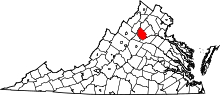 Location in the U.S. state of Virginia | |
 Virginia's location in the U.S. | |
| Founded | 1792 |
| Named for | Madison family |
| Seat | Madison |
| Largest town | Madison |
| Area | |
| • Total | 322 sq mi (834 km2) |
| • Land | 321 sq mi (831 km2) |
| • Water | 1.2 sq mi (3 km2), 0.4% |
| Population (est.) | |
| • (2016) | 13,099 |
| • Density | 41/sq mi (16/km2) |
| Congressional district | 5th |
| Time zone | Eastern: UTC−5/−4 |
| Website |
www |
Madison County is a county located in the Commonwealth of Virginia. As of the 2010 census, the population was 13,308.[1] Its county seat is Madison.[2]
History
Madison County was established in December 1792, created from Culpeper County.[3] The county is named for the Madison family that owned land along the Rapidan River. President James Madison is a descendant of that family.
Geography
According to the U.S. Census Bureau, the county has a total area of 322 square miles (830 km2), of which 321 square miles (830 km2) is land and 1.2 square miles (3.1 km2) (0.4%) is water.[4]
A significant portion of western Madison County is within Shenandoah National Park, including Hawksbill Mountain, the highest point in both the park and in Madison County, Old Rag Mountain, one of the park's most popular tourist destinations, and Rapidan Camp, the presidential retreat built by Herbert Hoover. Hoover's Camp was built between 1929 and 1932. The camp consisted of 13 buildings with the main one being "The Brown House". In 2017, only three of these houses are still standing (The Brown House, The Prime Minister Cabin, and The Creel). The camp was built where two streams merge to form the Rapidan River because fishing was Hoover's favorite pastime. Hoover even made sure that the camp was built at an elevation where mosquitos would not be a nuisance while fishing. The camp was donated to the Commonwealth of Virginia in 1932 so other presidents could use it and in December 1935 it officially became a part of Shenandoah National Park.[5]
Adjacent counties
- Page County, Virginia – northwest
- Rappahannock County, Virginia – north
- Culpeper County, Virginia – east
- Orange County, Virginia – southeast
- Greene County, Virginia – southwest
National protected area
- Shenandoah National Park (part)
Major highways
Demographics
| Historical population | |||
|---|---|---|---|
| Census | Pop. | %± | |
| 1800 | 8,322 | — | |
| 1810 | 8,381 | 0.7% | |
| 1820 | 8,490 | 1.3% | |
| 1830 | 9,236 | 8.8% | |
| 1840 | 8,107 | −12.2% | |
| 1850 | 9,331 | 15.1% | |
| 1860 | 8,854 | −5.1% | |
| 1870 | 8,670 | −2.1% | |
| 1880 | 10,562 | 21.8% | |
| 1890 | 10,225 | −3.2% | |
| 1900 | 10,216 | −0.1% | |
| 1910 | 10,055 | −1.6% | |
| 1920 | 9,595 | −4.6% | |
| 1930 | 8,952 | −6.7% | |
| 1940 | 8,465 | −5.4% | |
| 1950 | 8,273 | −2.3% | |
| 1960 | 8,187 | −1.0% | |
| 1970 | 8,638 | 5.5% | |
| 1980 | 10,232 | 18.5% | |
| 1990 | 11,949 | 16.8% | |
| 2000 | 12,520 | 4.8% | |
| 2010 | 13,308 | 6.3% | |
| Est. 2016 | 13,078 | [6] | −1.7% |
| U.S. Decennial Census[7] 1790–1960[8] 1900–1990[9] 1990–2000[10] 2010–2015[1] | |||
As of the census[11] of 2000, there were 12,520 people, 4,739 households, and 3,521 families residing in the county. The population density was 39 people per square mile (15/km²). There were 5,239 housing units at an average density of 16 per square mile (6/km²). The racial makeup of the county was 86.71% White, 11.41% Black or African American, 0.14% Native American, 0.50% Asian, 0.02% Pacific Islander, 0.29% from other races, and 0.93% from two or more races. 0.77% of the population were Hispanic or Latino of any race.
There were 4,739 households out of which 30.90% had children under the age of 18 living with them, 61.40% were married couples living together, 8.80% had a female householder with no husband present, and 25.70% were non-families. 21.80% of all households were made up of individuals and 9.50% had someone living alone who was 65 years of age or older. The average household size was 2.60 and the average family size was 3.03.
In the county, the population was spread out with 24.10% under the age of 18, 6.90% from 18 to 24, 27.60% from 25 to 44, 26.40% from 45 to 64, and 15.00% who were 65 years of age or older. The median age was 40 years. For every 100 females there were 95.00 males. For every 100 females age 18 and over, there were 94.60 males. There are more cows in Madison County than people.
The median income for a household in the county was $39,856, and the median income for a family was $44,857. Males had a median income of $30,805 versus $24,384 for females. The per capita income for the county was $18,636. About 6.90% of families and 9.60% of the population were below the poverty line, including 12.70% of those under age 18 and 10.20% of those age 65 or over.
Education
Madison County Public Schools has around 2000 students in four schools. Madison Primary School has grades K-2 and has around 370 students. Waverly Yowell Elementary School has grades 3–5 and around 410 students. William Wetsel Middle School has grades 6–8 and around 415 students. Madison County High School has grades 9–12 and has around 665 students. All statistics based on 2007–2008 VA DOE statistics. It is also home to Woodberry Forest School, a private, all-male boarding school.
Madison County High School
Madison County High School is the county's only High School. Grades 9–12 attend MCHS. The total number of students at MCHS was 584 for 2013–2014.[12] Madison County's nickname is the Mountaineers and have two main logos. One is an inked drawing of a Mountaineer standing on a mountain. In the background, a caravan of people and covered wagons can be seen being led by the Mountaineer. The second main logo is a "M" with a "C" offset and connected to it standing for Madison County, the name of both the county and high school. The colors are blue and white. MCHS fields athletic teams in football, basketball, soccer, volleyball, wrestling, track, cross country, golf, baseball and softball. Swimming was added as a sport in 2011. Cheerleading teams are also fielded for football and basketball games. Madison is home to the 2012 Group A, Division 1 state champions in Forensics.
MMCHS offers AP courses and dual enrollment courses through Germanna Community College. MCHS has full accreditation from the Virginia Department of Education with Virginia Standards of Learning passing rates ranging from 94 percent on the history to 86 percent on the science. MCHS graduates more than 90% of its students per year.
Communities
Towns
Census-designated place
Other unincorporated communities
- Achsah
- Aroda
- Aylor
- Banco
- Beaver Park
- Big Meadows
- Burnt Tree
- Criglersville
- Decapolis
- Duet
- Elly
- Etlan
- Five Forks
- Fletcher
- Fordsville
- Graves Mill
- Haywood
- Hood
- Kinderhook
- Leon
- Locust Dale
- Madison Mills
- Nethers
- Novum
- O'Neal
- Oakpark
- Oldrag
- Pratts
- Radiant
- Repton Mills
- Rochelle
- Ruth
- Shelby
- Shifflet Corner
- Syria
- Tanners
- Tryme
- Twyman's Mill
- Uno
- Waylandsburg
- Wolftown
- Zeus
Politics
| Year | Republican | Democratic | Third parties |
|---|---|---|---|
| 2016 | 63.3% 4,419 | 31.6% 2,203 | 5.1% 357 |
| 2012 | 58.5% 3,869 | 39.9% 2,639 | 1.6% 106 |
| 2008 | 56.1% 3,758 | 42.7% 2,862 | 1.2% 79 |
| 2004 | 61.6% 3,556 | 37.7% 2,176 | 0.7% 40 |
| 2000 | 58.5% 2,940 | 36.7% 1,844 | 4.8% 243 |
| 1996 | 50.9% 2,296 | 38.5% 1,734 | 10.6% 480 |
| 1992 | 49.0% 2,341 | 35.6% 1,700 | 15.4% 738 |
| 1988 | 62.1% 2,501 | 35.4% 1,427 | 2.4% 98 |
| 1984 | 67.2% 2,723 | 32.1% 1,302 | 0.7% 30 |
| 1980 | 55.6% 1,959 | 38.4% 1,351 | 6.0% 211 |
| 1976 | 53.0% 1,710 | 45.4% 1,466 | 1.6% 52 |
| 1972 | 73.4% 1,864 | 25.2% 639 | 1.4% 36 |
| 1968 | 48.7% 1,188 | 19.6% 478 | 31.7% 773 |
| 1964 | 55.1% 1,060 | 44.8% 862 | 0.1% 1 |
| 1960 | 60.4% 998 | 38.5% 636 | 1.2% 19 |
| 1956 | 56.9% 850 | 35.7% 533 | 7.5% 112 |
| 1952 | 65.0% 1,012 | 34.7% 540 | 0.4% 6 |
| 1948 | 55.7% 662 | 36.0% 428 | 8.3% 98 |
| 1944 | 56.8% 811 | 43.1% 616 | 0.1% 1 |
| 1940 | 48.1% 646 | 51.6% 692 | 0.3% 4 |
| 1936 | 45.1% 662 | 54.8% 804 | 0.1% 1 |
| 1932 | 37.8% 522 | 61.5% 849 | 0.7% 9 |
| 1928 | 57.1% 772 | 42.9% 580 | |
| 1924 | 35.7% 347 | 60.7% 589 | 3.6% 35 |
| 1920 | 45.8% 431 | 53.0% 499 | 1.2% 11 |
| 1916 | 37.5% 348 | 61.6% 572 | 0.9% 8 |
| 1912 | 31.0% 210 | 59.4% 402 | 9.6% 65 |
See also
References
- 1 2 "State & County QuickFacts". United States Census Bureau. Retrieved January 3, 2014.
- ↑ "Find a County". National Association of Counties. Retrieved 2011-06-07.
- ↑ "Madison County, Virginia". genealogenie.net. Retrieved 2018-08-21.
- ↑ "US Gazetteer files: 2010, 2000, and 1990". United States Census Bureau. 2011-02-12. Retrieved 2011-04-23.
- ↑ "Herbert and Lou Henry Hoover's Rapidan Camp--Presidents: A Discover Our Shared Heritage Travel Itinerary". www.nps.gov. Retrieved 2017-11-08.
- ↑ "Population and Housing Unit Estimates". Retrieved June 9, 2017.
- ↑ "U.S. Decennial Census". United States Census Bureau. Retrieved January 3, 2014.
- ↑ "Historical Census Browser". University of Virginia Library. Retrieved January 3, 2014.
- ↑ "Population of Counties by Decennial Census: 1900 to 1990". United States Census Bureau. Retrieved January 3, 2014.
- ↑ "Census 2000 PHC-T-4. Ranking Tables for Counties: 1990 and 2000" (PDF). United States Census Bureau. Retrieved January 3, 2014.
- ↑ "American FactFinder". United States Census Bureau. Retrieved 2011-05-14.
- ↑ VA Dept of Education. "School Report Card". VA State Govt.
- ↑ Leip, David. "Dave Leip's Atlas of U.S. Presidential Elections". uselectionatlas.org. Retrieved 2018-08-21.
External links
- Official Madison County Website
- Official Madison County Map
- Madison County Historical Society
- Madison County Chamber of Commerce
Places adjacent to Madison County, Virginia | ||||||||||
|---|---|---|---|---|---|---|---|---|---|---|
| ||||||||||
