Danville, Virginia
| Danville, Virginia | ||
|---|---|---|
| Independent city | ||
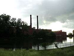
 Downtown Danville | ||
| ||
|
Nickname(s): River City, City of Churches | ||
| Motto(s): Reimagine That | ||
 Danville Location in the state of Virginia | ||
| Coordinates: 36°35′14″N 79°24′16″W / 36.58722°N 79.40444°WCoordinates: 36°35′14″N 79°24′16″W / 36.58722°N 79.40444°W | ||
| Country | United States | |
| State | Virginia | |
| County | None (Independent city) | |
| Government | ||
| • Mayor | Alonzo Jones | |
| Area | ||
| • Total | 43.9 sq mi (113.8 km2) | |
| • Land | 42.9 sq mi (111.2 km2) | |
| • Water | 1.0 sq mi (2.6 km2) | |
| Elevation | 531 ft (162 m) | |
| Population (2010) | ||
| • Total | 43,055 | |
| • Density | 1,004/sq mi (388/km2) | |
| Demonym(s) | Danvillian | |
| Time zone | UTC−5 (EST) | |
| • Summer (DST) | UTC−4 (EDT) | |
| Area code(s) | 434 | |
| FIPS code | 51-21344[1] | |
| GNIS feature ID | 1492837[2] | |
| Website |
www | |
Danville is an independent city in the Commonwealth of Virginia in the United States, located on the fall line of the Dan River. It was a major center of Confederate activity during the Civil War,[3] due to its strategic location on the Richmond and Danville Railroad, and today is principal city of the Danville, Virginia Micropolitan Statistical Area.
As of the 2010 census, the population was 43,055.[4] It is bounded by Pittsylvania County, Virginia and Caswell County, North Carolina. It hosts the Danville Braves baseball club of the Appalachian League.

History
Numerous Native American tribes had lived in this part of the Piedmont region since prehistoric times. During the colonial period, the area was inhabited by Siouan language-speaking tribes.
In 1728, English colonist William Byrd headed an expedition sent to determine the true boundary between Virginia and North Carolina. Late that summer, the party camped upstream from what is now Danville. Byrd was so taken with the beauty of the land, that he prophesied a future settlement in the vicinity, where people would live "with much comfort and gaiety of Heart." He named the river along which they camped as the "Dan", for Byrd felt he had wandered "from Dan to Beersheba."
After the American Revolutionary War, the first settlement developed in 1792 downstream from Byrd's campsite, at a spot along the river shallow enough to allow fording. It was named "Wynne's Falls", after the first settler. The village developed from the meetings of pioneering Revolutionary War veterans, who gathered annually here to fish and talk over old times.
In 1793, the state General Assembly authorized construction of a tobacco warehouse at Wynne's Falls. This marks the start of the town as "The World's Best Tobacco Market", Virginia's largest market for "bright leaf" tobacco. The village was renamed "Danville" by an act of November 23, 1793. A charter for the town was drawn up February 17, 1830, but by the time of its issue, the population had exceeded the pre-arranged boundaries. This necessitated a new charter, which was issued in 1833. In that year, James Lanier was elected the first mayor, assisted by a council of "twelve fit and able men". By the mid-19th century, William T. Sutherlin, a planter and entrepreneur, was the first to apply water power to run a tobacco press. He became a major industrialist in the region.
Several railroads reached Danville, including the Richmond and Danville Railroad (completed 1856), and the Atlantic and Danville Railway (completed 1890). These enabled the export of Danville's manufacturing and agricultural products. The major growth in industry came in the late 19th century, after the war. Southern Railways built a grand passenger station in Danville in 1899, which is still in use by Amtrak and for the first satellite facility of the Virginia Museum.
American Civil War


At the outbreak of the Civil War, Danville had a population of some 5,000 people. During those four years of war, the town was transformed into a strategic center of Confederate activity. Local planter and industrialist William T. Sutherlin was named quartermaster of its depot, the rail center was critical for supplying Confederate forces, and a hospital station was established for Confederate wounded. A network of batteries, breastworks, redoubts and rifle pits defended the town.[3]
A prison camp was set up, with the conversion of six tobacco warehouses, including one owned by Sutherlin, for use as prisons. At one time they held more than 5,000 captured Federal soldiers. Malnutrition and dysentery, plus a smallpox epidemic in 1864, caused the death of 1,314 of these prisoners. Their remains have been interred in the Danville National Cemetery.
The Richmond and Danville Railroad was the main supply route into Petersburg, where Lee's Army of Northern Virginia was holding the defensive line to protect Richmond. The Danville supply train ran until General Stoneman's Union cavalry troops tore up the tracks. This event was immortalized in the song, "The Night They Drove Old Dixie Down".
In 1865 Danville hosted the Confederate government. President Jefferson Davis stayed at the mansion of William T. Sutherlin from April 3 to 10, 1865, and it became known as the last "Capitol of the Confederacy".[5] Here he wrote and issued his last Presidential Proclamation. The final Confederate Cabinet meeting was held at the Benedict House (since destroyed) in Danville. Davis and members of his cabinet left the city when they learned of Lee's surrender at Appomattox, and moved to Greensboro, North Carolina, making their way south. On the day they left, Governor William Smith arrived from Lynchburg to establish his headquarters here.
Post-Reconstruction era to early 20th century
Given the falls on the river, the area was prime for industrial development based on water power. On July 22, 1882, six of Danville's residents (Thomas Benton Fitzgerald, Dr. H.W. Cole, Benjamin F. Jefferson and three brothers: Robert A., John H., and James E. Schoolfield) founded the Riverside Cotton Mills, making use of cotton produced throughout the South. In its day it was known nationally as Dan River Inc., the largest single-unit textile mill in the world.
The industrial town grew rapidly in the late 19th century, attracting many single workers, and associated gambling, drinking, and prostitution establishments. It was a rough place. By the early 20th century, the city passed laws against gambling, but it continued in small, private places.[6] On September 9, 1882, Danville mayor John H. Johnston shot and killed John E. Hatcher, his chief of police. Hatcher had demanded an apology for a statement Johnston had made regarding unaccounted fine money. Johnston was charged with murder, but he was acquitted at trial. The Southern "culture of honor" was still strong and jurors apparently believed the killing was justified.[7]
According to the Equal Justice Institute's 2015 report of lynchings in the South from 1877 to 1950, there were five lynchings in Danville, the second highest total of any independent city or county in the state.[8] This report included the deaths in the November 3, 1883, "Danville Riot", which took place a few days before the election. A racially motivated street fight grew larger and resulted in the shooting deaths of five men, four of them blacks. The blacks were reported as unarmed.[9]
In 1882 the biracial Readjuster Party had gained control of the city council, causing alarm and resentment among some whites, although the council was dominated by white members. The Readjuster Party had been in power at the state level since 1879. Social tensions had been rising in the city, which then had a majority African-American population. A street fight turned to shooting as a large crowd gathered. Afterward Democrats forced African Americans out of office and suppressed their voting. In November 1883 Democrats regained control of the state legislature by a large majority, and pushed out the Readjuster Party. A local Danville commission found African Americans at fault for the violence on November 3, but a US Senate investigation found whites at fault. No prosecution resulted from either inquiry.[9]
White Democratic legislators interpreted the Danville events as more reason to push blacks out of politics. In 1902 the state legislature passed a new constitution that raised barriers to voter registration, effectively disenfranchising most blacks and many poor whites, who had been part of the Readjuster Party. They excluded them from the political system, causing them to be underrepresented and their segregated facilities to be underfinanced.[10]
Southern Railways constructed a railroad line to the city in the late 19th century and had facilities here, which contributed to the growing economy. In 1899 the company completed a grand passenger station, designed by its noted architect Frank Pierce Milburn. For many years, passenger traffic was strong on the railroad; it also operated freight trains.
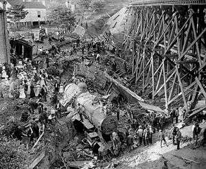
A serious train wreck occurred in Danville one September 27, 1903. "Old 97", the Southern Railway's crack express mail train, was running behind schedule. Its engineer "gave her full throttle", but the speed of the train caused it to jump the tracks while on a high trestle crossing the valley of the Dan River. The engine and five cars plunged into the ravine below, killing nine and injuring seven. The locomotive and its engineer, Joseph A. ("Steve") Broadey, were memorialized in song. A historic marker at the train crash site is located on U.S. 58 between Locust Lane and North Main Street. A mural of the Wreck of the Old 97 has been painted on a downtown Danville building to commemorate the incident.
On July 15, 1904, the Danville police successfully broke up a lynching party by firing warning shots above a crowd. About 75 white men had gathered at the jail to take Roy Seals, an African-American man arrested as a suspect in the murder of a white railroad worker. The police saved Seals and the city quickly indicted some of the lynch mob; several men were convicted, fined and served 30 days in jail. The killer was found to have been another white man, who was prosecuted.[11]
On March 2, 1911, Danville Police Chief R. E. Morris, who had been elected to three two-year terms and was running for a fourth term, was arrested as an escaped convicted murderer. He admitted that he was really Edgar Stribling of Harris County, Georgia. He had been on the run for thirteen years.[12]
On October 13, 1917, Walter Clark was lynched. He was an African-American man who had fatally shot a policeman while resisting arrest for the killing of his common-law wife. Clark held off the police for two hours, but a mob gathered and set his house on fire. He was shot multiple times and killed as he left the house. His was the last lynching in Danville.[11]
In the late 19th and early 20th centuries, tobacco processing was a major source of wealth for business owners in the city, in addition to the textile mills. Wealthy planters and owners built fine houses, some of which have been preserved.
Civil Rights Movement
Heightened activism in the Civil Rights Movement in Virginia occurred in Danville during the summer of 1963. Since the early 20th century, most blacks had been excluded from voting by the state constitution, which had created barriers to voter registration. White Democrats had imposed legal segregation after regaining control of the state legislature following the Reconstruction Era, and Jim Crow laws maintained white supremacy. On May 31, representatives of the black community organized as the Danville Christian Progressive Association (DCPA), demanding an end to segregation and job discrimination in the city. They declared a boycott of white merchants who refused to hire blacks and marched to City Hall in protest of conditions.
Most of the marchers were high school students. Police and city workers, armed with clubs, beat the young protesters and sprayed them with fire hoses. Around forty protesters needed medical attention, but the marches and other protests continued for several weeks.[13] Reverend Martin Luther King, Jr., leader of the Southern Christian Leadership Conference (SCLC), came to Danville and spoke at High Street Baptist Church about the police brutality. He said it was the worst he had seen in the South. The date of one protest on June 10, 1963, later came to be referred to as "Bloody Monday".[14]
The Student Nonviolent Coordinating Committee (SNCC) sent organizers to Danville to support the local movement. They helped lead protests, including demonstrations at the Howard Johnson Hotel and restaurant on Lee Highway. The hotel was known for discriminating locally against blacks as customers and excluding them as workers. A special grand jury indicted 13 DCPA, SCLC, and SNCC activists for violating the "John Brown" law. This law, passed in 1830 after a slave uprising, made it a serious felony to "...incite the colored population to acts of violence or war against the white population." It became known as the "John Brown" law in 1860 because it was used to convict and hang abolitionist John Brown after his raid on Harpers Ferry in 1859.[13]
By the end of August, more than 600 protesters had been arrested in Danville on charges of inciting to violence, contempt, trespassing, disorderly conduct, assault, parading without a permit, and resisting arrest. Because of the large number of arrests on these charges, often the jails were overcrowded, and protesters were housed in detention facilities in other nearby jurisdictions. The demonstrations failed to achieve desegregation in Danville at that time. Town facilities remained segregated until after passage of the Civil Rights Act of 1964. African-American residents were mostly unable to register and vote until after the federal government enforced their constitutional rights under the Voting Rights Act of 1965.[13]
Late 20th century to present
Since the late 20th century, the textile industry has moved to offshore, cheaper labor markets. The Dan River mill has closed and many of its buildings have been torn down, with the bricks sold for other uses. "The White Mill" of the Dan Mill complex, considered historically and architecturally significant, is being renovated in the early 21st century as an apartment complex.
In the late 20th century, the restructuring of the tobacco, textile, and railroad industries all had an adverse effect here, resulting in the loss of many jobs in Danville. The decline in passenger traffic caused the Danville station to fall into misuse. It was listed on the National Register of Historic Places in 1995, and has been renovated by a combination of public and private funding. Today its transportation center serves Amtrak passengers, with part of the station devoted to the first satellite facility of the Science Museum of Virginia. Related spaces have been developed for a park with amphitheater, a community meeting and recreation facility, and the Danville Farmer's Market. The city used ISTEA funds in association with the Virginia Department of Transportation, and partnered also with Amtrak, Pepsi-Cola, and other private sources. The station renovations were completed in 1996. This project spurred investment in other warehouse properties, "which have been redeveloped into offices, commercial spaces, apartments, lofts, and restaurants. The approximately $4 million of federal grant money initiated the redevelopment and leveraged additional funds from public and private sources."[15]
The city and region continue to work to develop new bases for the economy. The losses have made it difficult to preserve the city's many architecturally and historically significant properties dating from its more prosperous years. In 2007 Preservation Virginia President William B. Kerkam, III, and its Executive Director Elizabeth S. Kostelny announced at a press conference held in Danville at Main Street Methodist Church that the entire city of Danville had been named as one of the Most Endangered Historic Sites in Virginia. It is working to preserve and redevelop the River District as a center for the community and to stimulate heritage tourism.
Geography
Danville is located along the southern border of Virginia, 70 miles (110 km) south of Lynchburg and 45 miles (72 km) northeast of Greensboro, North Carolina, via U.S. Route 29. U.S. Route 58 leads east 78 miles (126 km) to South Hill and west 30 miles (48 km) to Martinsville.
According to the United States Census Bureau, the city has a total area of 43.9 square miles (113.7 km2), of which 43.1 square miles (111.6 km2) is land and 1.0 square mile (2.6 km2) (2.3%) is water.[16]
Climate
| Climate data for Danville, Virginia (Danville Regional Airport), 1981–2010 normals | |||||||||||||
|---|---|---|---|---|---|---|---|---|---|---|---|---|---|
| Month | Jan | Feb | Mar | Apr | May | Jun | Jul | Aug | Sep | Oct | Nov | Dec | Year |
| Average high °F (°C) | 46.4 (8) |
50.1 (10.1) |
59.1 (15.1) |
69.8 (21) |
77.4 (25.2) |
84.7 (29.3) |
87.9 (31.1) |
86.3 (30.2) |
79.8 (26.6) |
70.0 (21.1) |
60.2 (15.7) |
49.6 (9.8) |
68.4 (20.2) |
| Average low °F (°C) | 29.2 (−1.6) |
31.9 (−0.1) |
37.1 (2.8) |
45.3 (7.4) |
55.5 (13.1) |
65.1 (18.4) |
68.7 (20.4) |
67.9 (19.9) |
60.2 (15.7) |
49.0 (9.4) |
38.3 (3.5) |
30.6 (−0.8) |
48.7 (9.3) |
| Average precipitation inches (mm) | 3.42 (86.9) |
3.01 (76.5) |
4.11 (104.4) |
3.46 (87.9) |
3.88 (98.6) |
3.85 (97.8) |
4.59 (116.6) |
3.97 (100.8) |
3.96 (100.6) |
3.53 (89.7) |
3.36 (85.3) |
3.27 (83.1) |
44.41 (1,128) |
| Average snowfall inches (cm) | 2.2 (5.6) |
1.3 (3.3) |
.4 (1) |
.1 (0.3) |
0 (0) |
0 (0) |
0 (0) |
0 (0) |
0 (0) |
0 (0) |
0 (0) |
.5 (1.3) |
4.7 (11.9) |
| Average precipitation days (≥ 0.01 in) | 10.1 | 9.2 | 10.3 | 10.4 | 10.9 | 9.5 | 10.8 | 9.0 | 8.2 | 7.7 | 8.9 | 9.4 | 114.4 |
| Average snowy days (≥ 0.1 in) | 0.9 | 0.5 | 0.1 | 0.1 | 0 | 0 | 0 | 0 | 0 | 0 | 0 | 0.3 | 1.9 |
| Source: NOAA[17] | |||||||||||||
Demographics
| Historical population | |||
|---|---|---|---|
| Census | Pop. | %± | |
| 1850 | 1,514 | — | |
| 1870 | 3,463 | — | |
| 1880 | 7,426 | 114.4% | |
| 1890 | 10,305 | 38.8% | |
| 1900 | 16,520 | 60.3% | |
| 1910 | 19,020 | 15.1% | |
| 1920 | 21,539 | 13.2% | |
| 1930 | 22,247 | 3.3% | |
| 1940 | 32,749 | 47.2% | |
| 1950 | 35,066 | 7.1% | |
| 1960 | 46,577 | 32.8% | |
| 1970 | 46,391 | −0.4% | |
| 1980 | 45,642 | −1.6% | |
| 1990 | 53,056 | 16.2% | |
| 2000 | 48,411 | −8.8% | |
| 2010 | 43,055 | −11.1% | |
| Est. 2016 | 41,898 | [18] | −2.7% |
| U.S. Decennial Census[19] 1790-1960[20] 1900-1990[21] 1990-2000[22] 2010-2013[4] | |||
As of the census[23] of 2010, Danville had a population of 43,055. The racial makeup of the city was White Non-Hispanic 46.7%, African American 48.3%, Hispanic 2.9%, Asian 0.9%, American Indian or Alaska Native 0.2%, and two or more races 1.3%.
25.4% of the population never married, 46.6% were married, 5.4% were separated. 11.6% were widowed and 11.0% were divorced.[24] There were 59 registered sex offenders living in Danville in early 2007.[25]
Economy
Businesses
- Danville Regional Medical Center[26]
- Goodyear[26]
- Nestlé[26]
- Essel Propack opened its U.S subsidiary in Danville in 2002.
- Swedwood, a subsidiary of IKEA, opened its first factory in the U.S. in this city, in 2008. It employed more than 300 people.[27]
Arts and culture
River District
Prior to the recession of 2008, the City of Danville and its partners began a major project focused on the revitalization of the Historic Downtown and Tobacco Warehouse districts, now coined “The River District.” Today, the project continues with a new momentum as the public sector has joined the movement. See Danville River District.
Garland Street and historic districts

Millionaire's Row has many homes built in the late 19th and early 20th centuries by successful tobacco planters, who gained their wealth in this commodity crop. An example is the Penn-Wyatt House, built in 1876 on Main Street. The mansions are in an area of many street trees and often have their own well-developed landscaping.
The entire area of "Penn's Bottom", the nickname for the part of Main Street that was developed as the first suburb of Danville during the tobacco boom of the late 19th century, has been designated as a historic district. Other recognized historic districts include The Old West End, Tobacco Warehouse, Downtown Danville, Holbrook-Ross Street, and North Main.
Since the early 21st century, there has been increased investment and renovation in these areas. The city is capitalizing on its heritage: The many examples of Victorian architecture are showcased every holiday season with the Christmas Tour.
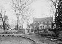
Also located in this district is the "Sutherlin Mansion", now used as the Danville Museum of Fine Arts and History. This Italianate mansion was the plantation home of Major William T. Sutherlin, a major tobacco processing industrialist, banker, politician, and Confederate quartermaster. In April 1865, he offered his mansion to President Jefferson Davis and his cabinet as the site of the last "Capitol of the Confederacy" after the fall of Richmond. The museum and its grounds occupy a block in this district. In the late 19th century, Sutherlin's surrounding plantation was subdivided and developed to create the surrounding residential neighborhood.
City of churches
Danville is known as "the city of churches" because it has more churches per square mile than any other city in the state of Virginia.[28]
Shopping
Danville Mall, formerly Piedmont Mall, opened in 1984.
Government
| Year | Republican | Democratic | Third parties |
|---|---|---|---|
| 2016 | 38.6% 7,303 | 58.4% 11,059 | 3.1% 578 |
| 2012 | 38.4% 7,763 | 60.5% 12,218 | 1.1% 223 |
| 2008 | 40.0% 8,361 | 59.1% 12,352 | 0.9% 177 |
| 2004 | 49.2% 9,399 | 49.4% 9,436 | 1.5% 277 |
| 2000 | 51.5% 9,427 | 44.9% 8,221 | 3.6% 659 |
| 1996 | 50.0% 9,254 | 44.1% 8,168 | 5.9% 1,097 |
| 1992 | 48.8% 9,584 | 41.4% 8,134 | 9.9% 1,943 |
| 1988 | 61.5% 12,221 | 37.0% 7,353 | 1.5% 300 |
| 1984 | 66.9% 12,141 | 32.2% 5,846 | 1.0% 174 |
| 1980 | 61.4% 10,665 | 35.4% 6,138 | 3.2% 559 |
| 1976 | 59.5% 10,235 | 37.3% 6,425 | 3.2% 552 |
| 1972 | 73.7% 12,463 | 24.5% 4,148 | 1.8% 305 |
| 1968 | 40.3% 6,796 | 26.6% 4,495 | 33.1% 5,583 |
| 1964 | 62.1% 7,900 | 35.7% 4,539 | 2.2% 285 |
| 1960 | 63.7% 4,966 | 33.5% 2,611 | 2.8% 217 |
| 1956 | 59.0% 4,561 | 31.2% 2,409 | 9.8% 756 |
| 1952 | 58.5% 4,765 | 40.8% 3,323 | 0.7% 58 |
| 1948 | 29.0% 1,579 | 42.8% 2,334 | 28.2% 1,535 |
| 1944 | 28.2% 1,231 | 71.5% 3,121 | 0.3% 14 |
| 1940 | 19.0% 787 | 80.3% 3,324 | 0.7% 30 |
| 1936 | 14.3% 549 | 84.9% 3,266 | 0.8% 30 |
| 1932 | 24.0% 740 | 73.4% 2,264 | 2.6% 80 |
| 1928 | 66.4% 2,360 | 33.6% 1,196 | |
| 1924 | 21.1% 473 | 70.4% 1,577 | 8.5% 191 |
| 1920 | 22.3% 551 | 76.3% 1,888 | 1.5% 37 |
| 1916 | 15.3% 229 | 77.0% 1,151 | 7.7% 115 |
| 1912 | 7.4% 93 | 84.6% 1,066 | 8.0% 101 |
Municipal
The City of Danville has a council-manager government in which a city manager is hired by council to supervise the city government and ensure that the ordinances and policies made by the city council are carried out in an effective manner.[30] The city council consists of nine members elected from single-member districts representing residents. The city council selects the mayor and vice mayor from among its members to serve two-year terms.[30] The city council has the power "to adopt and enforce legislative and budgetary ordinances, policies, and rules and regulations necessary to conduct the public's business and to provide for the protection of the general health, safety and welfare of the public."[30]
Education
Schools
- Galileo Magnet High School
- George Washington High School
- Piedmont Governor's School for Mathematics, Science, and Technology
- Westover Christian Academy
- Carlisle School (Danville)
- Sacred Heart Catholic School
- O.T. Bonner Middle School
- Westwood Middle School
- E.A. Gibson Elementary School
- Forest Hills Elementary School
- G.L.H. Johnson Elementary School
- Park Avenue Elementary School
- Schoolfield Elementary School
- Woodberry Hills Elementary School
Colleges and universities
- Averett University
- Danville Community College
- American National University, formerly known as National College of Business and Technology
Media
Newspapers
- Chatham Star Tribune
- Danville Register & Bee
Magazines
- Evince
- Showcase Magazine
Broadcast
- WMDV-LD, an independent television station owned by the Martinsville, VA-based Star News Corporation
- WAKG (103.3 FM)
- WBTM (102.5 FM)[31]
- WDVA (1250 AM)[32][33]
- WMPW (105.9 FM), branded as MoreFM[34]
- WWDN (104.5 FM)[35]
Danville was once the home of WDRL-TV 24, a station that was an affiliate of the WB and United Paramount Network before changing ownership from 2007 to 2014. Today, it is known as WFFP TV[36]
Infrastructure
Transportation
Railroad
Amtrak's Crescent train connects Danville with the cities of New York, Philadelphia, Baltimore, Washington, Charlotte, Atlanta, Birmingham and New Orleans. The Amtrak station, built in 1899 by Southern Railways, is situated at 677 Craghead Street.
Highways
U.S. Route 58 (Riverside Dr/River St) parallels the north bank of the Dan River traveling east–west through Danville's main commercial district while the US 58 Bypass route bypasses the city's center to the south via the Danville Expressway. U.S. Route 29 splits into a business route and a bypass at the North Carolina/Virginia border. The business route enters the heart of Danville via West Main Street and Memorial Drive and exits via Central Boulevard and Piney Forest Road; US 29 Business travels relatively north–south. The bypass (future Interstate 785) takes the eastern segment of the Danville Expressway and rejoins the business route north of the city near Chatham, Virginia.
U.S. Route 360, which connects Danville with Richmond, enters the city from the east concurrent with U.S. Route 58 (South Boston Road), continuing along U.S. Route 58 Business at the Danville Expressway interchange, and terminating at the North Main Street intersection just north of downtown.
U.S. Route 311 in 2013 was expanded from North Carolina to terminate just outside Danville's western limits at U.S. Route 58.
North Carolina Highway 86 becomes State Route 86 once it crosses the state line into Danville as South Main Street. It continues north to its terminus at US 29 Business/Central Boulevard.
State Route 293 was created in 1998 to mark the route of old US 29 Business, which was rerouted to the west. SR 293 enters Danville's downtown historic district as West Main Street, then Main Street, and then crosses the Dan River to meet US 29 Business as North Main Street.
State Route 51 parallels US 58 Business as Westover Drive from its western terminus at US 58 Business at the Danville's corporate limits to its eastern terminus at US 58 Business near the Dan River.
Notable people
- Nancy Astor, Viscountess Astor (born Nancy Langhorne), elected as member, British House of Commons
- Samuel Bason, Yanceyville, North Carolina, banker and businessman and member of the North Carolina State Senate, 1948-1956; spent his last years at a convalescent home in Danville[37]
- Barry Beggarly, Short track race car driver[38]
- William Lewis Cabell, Confederate brigadier general and mayor of Dallas
- Clarence 13X, The Nation of Gods and Earths founder[39]
- Buddy Curry, Atlanta Falcons player
- Jon Dalton, reality television personality (also known as Johnny Fairplay)
- Frederick Delius, classical music composer, 1885-1886
- Ferrell Edmunds, NFL player
- Robert H. Edmunds, Jr., North Carolina Supreme Court justice
- Tremaine Edmunds, NFL player
- Blind Boy Fuller, blues guitarist and vocalist, street performer in Danville
- Emmet Gowin, photographer
- J. Hartwell Harrison, M.D., instrumental in the world's first kidney transplant
- Richard Benjamin Harrison, star of the reality television series Pawn Stars.[40]
- John B. Henderson, U.S. Senator from Missouri
- Jules James, Vice Admiral, U.S. Navy, during World War II; awarded the French Legion of Honour
- George M. La Monte, paper manufacturer, politician, philanthropist
- Teresa Lewis, a murderer who was the first woman executed by lethal injection in Virginia
- Margaret Livingstone, neurobiologist and professor at Harvard Medical School
- Percy Miller, Jr., first black baseball player in the Carolina League
- Jim Mitchell, NFL player (defensive end, Detroit Lions 1970-1977), Virginia State University football player (https://en.wikipedia.org/wiki/Jim_Mitchell_(defensive_lineman))[41]
- Herman Moore, NFL player, University of Virginia football player
- Johnny Newman, NBA player
- Mojo Nixon, psychobilly musician and Sirius Satellite Radio host
- Eric Owens, former Major League Baseball player
- Timothy Peters, NASCAR racecar driver
- Nate Poole, NFL player
- Tony Rice, bluegrass musician
- James I. Robertson, Jr., historian, professor of history at Virginia Tech
- Wendell Scott, first African-American NASCAR driver
- Peyton Sellers, NASCAR driver
- Charles Stanley, former president of Southern Baptist Convention, senior pastor of First Baptist Church Atlanta, and founder and president of In Touch Ministries
- Skipp Sudduth, actor (Ronin and Third Watch)
- William T. Sutherlin, planter, industrialist and politician; the first to apply steam power to tobacco hydraulics press, founder and president of Bank of Danville, hosted President Jefferson Davis and his cabinet for last week of the Confederacy government
- Don Testerman, professional football player[42]
- Charles Tyner, actor (Sweet Bird of Youth (play) and Cool Hand Luke)[43]
- Ricky Van Shelton, country music singer
- Camilla Ella Williams, opera singer, first African American contracted to sing with New York City Opera
- Andra Willis, singer on The Lawrence Welk Show
- David Wilson, football player for the New York Giants
- Henry Lumpkin Wilson, physician in Atlanta who served as Confederate army chief physician, later known as real estate developer and investor, local politician, drug retailer
- Tony Womack, Major League Baseball player[44]
See also
References
- ↑ "American FactFinder". United States Census Bureau. Archived from the original on 2013-09-11. Retrieved 2008-01-31.
- ↑ "US Board on Geographic Names". United States Geological Survey. 2007-10-25. Retrieved 2008-01-31.
- 1 2 DeNordendorff, Charles. "Map of Danville Defences 1863". University of North Carolina at Chapel Hill. Retrieved 8 June 2016.
- 1 2 "State & County QuickFacts". United States Census Bureau. Archived from the original on January 22, 2014. Retrieved January 5, 2014.
- ↑ [https://books.google.com/books?id=Ia9_CQAAQBAJ&pg=PT59&dq=Danville+lynchings&hl=en&sa=X&ved=0ahUKEwiG6taKovHZAhXPyVMKHVM8CVYQ6AEIKTAA#v=onepage&q=Danville%20lynchings&f=false Frankie Y. Bailey, Alice P. Green, Wicked Danville: Liquor and Lawlessness in a Southside Virginia City, Arcadia Publishing, 2011, n.p.
- ↑ Frankie Y. Bailey, Alice P. Green, Chapter 3: "Public Order Crimes", in Wicked Danville: Liquor and Lawlessness in a Southside Virginia City], Arcadia Publishing, 2011, n.p.
- ↑ "John Epps Hatcher". Hatcher Families Genealogy Society.
- ↑ Lynching in America, 2nd edition, Supplement by County, p. 7
- 1 2 B. Wolfe, "Danville Riot (1883)", Encyclopedia of Virginia, 2015
- ↑ Brent Tarter, "Post-Reconstruction Suffrage and following sections", Disfranchisement, Encyclopedia of Virginia, 19 July 2016; accessed 17 March 2018
- 1 2 Frankie Y. Bailey, Alice P. Green, Chapter 4: "Rituals, Trouble and Repressive Justice", in Wicked Danville: Liquor and Lawlessness in a Southside Virginia City, Arcadia Publishing, 2011, n.p.
- ↑ "Arrest Police Chief as Escaped Convict", The New York Times, March 3, 1911. Retrieved January 10, 2008.
- 1 2 3 Civil Rights Movement Veterans. "Danville VA, Movement".
- ↑ Crane, John R. (June 2, 2013). "Bloody Monday: History-changing day". News-Advance. Retrieved 4 November 2015.
- ↑ "Danville, VA (DAN)", The Great American Stations, 2013-2018, Amtrak; accessed 17 March 2018
- ↑ "US Gazetteer files: 2010, 2000, and 1990". United States Census Bureau. 2011-02-12. Retrieved 2011-04-23.
- ↑ "NowData - NOAA Online Weather Data". National Oceanic and Atmospheric Administration. Retrieved 2013-07-03.
- ↑ "Population and Housing Unit Estimates". Retrieved June 9, 2017.
- ↑ "U.S. Decennial Census". United States Census Bureau. Archived from the original on May 12, 2015. Retrieved January 5, 2014.
- ↑ "Historical Census Browser". University of Virginia Library. Retrieved January 5, 2014.
- ↑ "Population of Counties by Decennial Census: 1900 to 1990". United States Census Bureau. Retrieved January 5, 2014.
- ↑ "Census 2000 PHC-T-4. Ranking Tables for Counties: 1990 and 2000" (PDF). United States Census Bureau. Retrieved January 5, 2014.
- ↑ "American FactFinder". United States Census Bureau. Archived from the original on 2013-09-11. Retrieved 2011-05-14.
- ↑ "Danville, Virginia (VA 24541)". city-data.com. Retrieved 11 June 2016.
- ↑ "Registered sex offenders in Danville, Virginia". city-data.com. Retrieved 11 June 2016.
- 1 2 3
- ↑ Popper, Nathaniel (April 10, 2011). "Ikea's U.S. factory churns out unhappy workers". Los Angeles Times. Retrieved 2011-08-23.
- ↑ "Danville, VA". Forbes. Retrieved 11 June 2016.
- ↑ Leip, David. "Dave Leip's Atlas of U.S. Presidential Elections". uselectionatlas.org.
- 1 2 3 "City Council". City of Danville. Retrieved March 26, 2018.
- ↑ "WBTM". 31 July 2016. Retrieved 30 April 2017 – via Wikipedia.
- ↑ "WDVA". 24 August 2016. Retrieved 30 April 2017 – via Wikipedia.
- ↑ "WDVA 1250 AM". Retrieved 30 April 2017.
- ↑ "WMPW-AC". Retrieved 30 April 2017.
- ↑ "WWDN-FM". Retrieved 30 April 2017.
- ↑ "WFFP-TV". 25 April 2017. Retrieved 30 April 2017 – via Wikipedia.
- ↑ Jeannie D. Whitlow with Carolyn Bason Long (1985). "Caswell County Family Tree". The Heritage of Caswell County, North Carolina on wc.rootsweb.ancestry.com. Retrieved July 29, 2015.
- ↑ "Racer Meterics: Barry Beggarly". Race Database. Retrieved 16 February 2016.
- ↑ Muhammad, Kathy Makeda Bennett (2011). Humble Warrioress: Women in the Nation of Islam. ProQuest, 2011. p. 59.
- ↑ Steve Huffman (February 18, 2011). "'The Old Man' from 'Pawn Stars' recalls growing up in Lexington". The-Dispatch.com. Retrieved June 2, 2012.
- ↑ Wikipedia https://en.wikipedia.org/wiki/Jim_Mitchell_(defensive_lineman). Retrieved July 27, 2018. Missing or empty
|title=(help) - ↑ "Don Testerman". Pro-Football Reference. Retrieved 7 August 2016.
- ↑ "Charles Tyner". imdb.com. Retrieved 11 June 2016.
- ↑ "Tony Womack". Baseball-Reference.Com. Retrieved October 14, 2012.
Sources
- "Danville, Virginia". City-Data.com. Retrieved July 11, 2012.
Further reading
- Calhoun, Walter T. "The Danville Riot and Its Repercussions on the Virginia Election of 1883." In Studies in the History of the South, 1875–1922, edited by Joseph F. Steelman et al., 25–51. Greenville, North Carolina: East Carolina College, 1966.
- Dailey, Jane. "Deference and Violence in the Postbellum Urban South: Manners and Massacres in Danville, Virginia." Journal of Southern History 63, no. 3 (August, 1997): 553–590.
External links
| Wikivoyage has a travel guide for Danville (Virginia). |
| Wikimedia Commons has media related to Danville, Virginia. |
- City of Danville official website
- City of Danville Office of Economic Development
- Danville Pittsylvania County Chamber of Commerce
- Danville Parks & Recreation
Places adjacent to Danville, Virginia | ||||||||||
|---|---|---|---|---|---|---|---|---|---|---|
| ||||||||||
