Westmoreland County, Virginia
| Westmoreland County, Virginia | ||
|---|---|---|
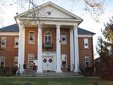 Westmoreland County Courthouse in Montross | ||
| ||
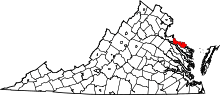 Location in the U.S. state of Virginia | ||
 Virginia's location in the U.S. | ||
| Seat | Montross | |
| Largest town | Colonial Beach | |
| Area | ||
| • Total | 253 sq mi (655 km2) | |
| • Land | 229 sq mi (593 km2) | |
| • Water | 24 sq mi (62 km2), 9.3% | |
| Population (est.) | ||
| • (2015) | 17,629 | |
| • Density | 70/sq mi (28/km2) | |
| Congressional district | 1st | |
| Time zone | Eastern: UTC−5/−4 | |
| Website |
www | |

Westmoreland County is a county located in the Northern Neck of the Commonwealth of Virginia. At the 2010 census, the population was 17,454.[1] Its county seat is Montross.[2]
History
As originally established by the Virginia colony's House of Burgesses, it was separated out of Northumberland County in 1653, and the territory of Westmoreland County encompassed much of what later became the various counties and cities of Northern Virginia, including the city of Alexandria, Arlington County, Fairfax County, and Prince William County. These were part of Westmoreland until 1664, when Stafford County was formed.
Westmoreland County was the birthplace of George Washington, the first President of the United States (at the former settlement of Bridges Creek, Virginia);[3] of James Monroe, the fifth President; and of General Robert E. Lee, commander of the Confederate armies.
The county was the place of residence for Colonel Nicholas Spencer (1633-1689), who patented the land at Mount Vernon in 1674 with his friend Lt. Col. John Washington, ancestor of George Washington. Spencer, who served as President of the Council and acting Governor of the Colony of Virginia, was the cousin of, and agent for, the Barons Colepeper, proprietors of the Northern Neck. Spencer lived at his plantation, Nomini, which his descendants later sold to Robert Carter I. Robert Carter's grandson, Robert Carter III, voluntarily freed almost 500 slaves from Nomini Hall beginning in 1791 and settled many on lands he gave them. His manumission is the largest known release of slaves in North America prior to the American Civil War and the largest number ever manumitted by an individual in the U.S.[4]
Geography
According to the U.S. Census Bureau, the county has a total area of 253 square miles (660 km2), of which 229 square miles (590 km2) is land and 24 square miles (62 km2) (9.3%) is water.[5] The county is located on the Northern Neck and is part of the Northern Neck George Washington Birthplace AVA winemaking appellation.
Adjacent counties
- Charles County, Maryland - north
- St. Mary's County, Maryland - northeast
- Northumberland County, Virginia - southeast
- Richmond County, Virginia - south
- Essex County, Virginia - southwest
- King George County, Virginia - northwest
National protected areas
- George Washington Birthplace National Monument
- Rappahannock River Valley National Wildlife Refuge (part) Mothershead unit
Demographics
| Historical population | |||
|---|---|---|---|
| Census | Pop. | %± | |
| 1820 | 6,901 | — | |
| 1830 | 8,396 | 21.7% | |
| 1840 | 8,019 | −4.5% | |
| 1850 | 8,080 | 0.8% | |
| 1860 | 8,282 | 2.5% | |
| 1870 | 7,682 | −7.2% | |
| 1880 | 8,846 | 15.2% | |
| 1890 | 8,399 | −5.1% | |
| 1900 | 9,243 | 10.0% | |
| 1910 | 9,313 | 0.8% | |
| 1920 | 10,240 | 10.0% | |
| 1930 | 8,497 | −17.0% | |
| 1940 | 9,512 | 11.9% | |
| 1950 | 10,148 | 6.7% | |
| 1960 | 11,042 | 8.8% | |
| 1970 | 12,142 | 10.0% | |
| 1980 | 14,041 | 15.6% | |
| 1990 | 15,480 | 10.2% | |
| 2000 | 16,718 | 8.0% | |
| 2010 | 17,454 | 4.4% | |
| Est. 2016 | 17,592 | [6] | 0.8% |
| U.S. Decennial Census[7] 1790-1960[8] 1900-1990[9] 1990-2000[10] 2010-2013[1] | |||
At the 2000 census,[11] there were 16,718 people, 6,846 households and 4,689 families residing in the county. The population density was 73/sq mi (28/km2). There were 9,286 housing units at an average density of 40/sq mi (15/km2). The racial makeup of the county was 65.41% White, 30.89% Black or African American, 0.28% Native American, 0.36% Asian, 0.01% Pacific Islander, 1.75% from other races, and 1.29% from two or more races. 3.46% of the population were Hispanic or Latino of any race.
There were 6,846 households of which 25.70% had children under the age of 18 living with them, 50.70% were married couples living together, 13.50% had a female householder with no husband present, and 31.50% were non-families. 26.90% of all households were made up of individuals and 13.60% had someone living alone who was 65 years of age or older. The average household size was 2.43 and the average family size was 2.91.
23.00% of the population were under the age of 18, 6.30% from 18 to 24, 23.90% from 25 to 44, 27.80% from 45 to 64, and 19.00% who were 65 years of age or older. The median age was 43 years. For every 100 females, there were 92.30 males. For every 100 females age 18 and over, there were 88.90 males.
The median household income was $35,797 and the median family income was $41,357. Males had a median income of $31,333 and females $22,221. The per capita income was $19,473. About 11.20% of families and 14.70% of the population were below the poverty line, including 21.10% of those under age 18 and 12.50% of those age 65 or over.
Economy
The county's economy is largely based on agriculture. Tourism is another significant economic driver, related to historical sites such as George Washington Birthplace National Monument and Robert E. Lee's birthplace, Stratford Hall Plantation, and the Westmoreland County Museum as well as gambling activities available in Colonial Beach. The county is also an extended exurb of Washington, D.C..
Northern Neck Coca-Cola Bottling Inc. (makers of Northern Neck Ginger Ale) and the weekly Westmoreland News are located in Montross.
Notable residents

- George Washington (1732-1799), the first president of the United States
- John Washington (1631-1677), great-grandfather of George Washington
- Bushrod Washington (1762-1829), Associate Justice of the Supreme Court, founder and first president of the American Colonization Society, nephew of George Washington and inheritor of Mount Vernon
- James Monroe (1758-1831), the fifth president of the United States
- Robert E. Lee (1807-1870), a general best known for fighting on behalf of the Confederate Army in the American Civil War
- Richard Henry Lee, a signatory of the United States Declaration of Independence, United States Senator, and the sixth president of the United States in Congress Assembled (under the Articles of Confederation)
- Francis Lightfoot Lee, a signer of United States Declaration of Independence
- Richard "Squire" Lee
- Thomas Brown, the second governor of Florida
- Nicholas Spencer, acting governor of Virginia, co-patentee of Mount Vernon estate
- Thomas Lee, a leading political figure in colonial Virginia
- Thomas Sandford, American Revolutionary War soldier, Kentucky legislator, Member of the Eighth and Ninth U.S. Congress.
- Sloan Wilson, the author of The Man in the Gray Flannel Suit
- Rob Wittman, United States Congressman (VA-1, Republican)
- Thomas Marshall (1700-1752) Grandfather of Chief Justice John Marshall
- Walter Balderson, Emmy Award-winning video engineer
- John dos Passos, the author of the U.S.A. trilogy and other works
Communities
Towns
Politics
Westmoreland County is a notable bellwether for U.S. Presidential politics, having voted for the winner in every election since 1964.
| Year | Republican | Democratic | Third parties |
|---|---|---|---|
| 2016 | 51.9% 4,448 | 44.7% 3,836 | 3.4% 290 |
| 2012 | 46.0% 3,731 | 52.9% 4,295 | 1.2% 94 |
| 2008 | 44.4% 3,719 | 54.6% 4,577 | 1.0% 81 |
| 2004 | 50.1% 3,433 | 49.2% 3,370 | 0.7% 45 |
| 2000 | 48.7% 2,932 | 48.5% 2,922 | 2.9% 172 |
| 1996 | 40.3% 2,333 | 51.0% 2,949 | 8.7% 506 |
| 1992 | 41.0% 2,554 | 44.3% 2,758 | 14.6% 911 |
| 1988 | 55.4% 2,974 | 43.0% 2,311 | 1.6% 85 |
| 1984 | 56.8% 3,219 | 41.7% 2,363 | 1.4% 81 |
| 1980 | 50.3% 2,510 | 45.5% 2,271 | 4.2% 208 |
| 1976 | 41.8% 1,909 | 51.6% 2,355 | 6.7% 304 |
| 1972 | 66.0% 2,331 | 31.5% 1,113 | 2.5% 88 |
| 1968 | 40.0% 1,402 | 33.0% 1,156 | 27.0% 948 |
| 1964 | 47.3% 1,181 | 52.5% 1,312 | 0.2% 6 |
| 1960 | 53.0% 1,176 | 46.6% 1,034 | 0.4% 9 |
| 1956 | 54.5% 1,033 | 36.6% 695 | 8.9% 169 |
| 1952 | 59.5% 1,117 | 40.2% 754 | 0.3% 6 |
| 1948 | 44.5% 568 | 39.4% 503 | 16.1% 205 |
| 1944 | 39.6% 532 | 60.1% 808 | 0.3% 4 |
| 1940 | 29.7% 357 | 70.2% 845 | 0.1% 1 |
| 1936 | 25.4% 296 | 74.6% 871 | |
| 1932 | 24.7% 212 | 74.8% 641 | 0.5% 4 |
| 1928 | 58.5% 554 | 41.5% 393 | |
| 1924 | 24.0% 157 | 73.9% 484 | 2.1% 14 |
| 1920 | 25.1% 133 | 74.7% 396 | 0.2% 1 |
| 1916 | 27.1% 126 | 72.7% 338 | 0.2% 1 |
| 1912 | 15.2% 69 | 75.0% 341 | 9.9% 45 |
See also
References
- 1 2 "State & County QuickFacts". United States Census Bureau. Retrieved January 5, 2014.
- ↑ "Find a County". National Association of Counties. Retrieved 2011-06-07.
- ↑ Marquis, A.N. Company. Who's Who In America, vol. 1:Historical Volume (1607-1896), revised ed., Marquis, A.N. Company., 1967.
- ↑ Andrew Levy, The First Emancipator: The Forgotten Story of Robert Carter, the Founding Father who freed his slaves. New York: Random House, 2005 ( ISBN 0-375-50865-1)
- ↑ "US Gazetteer files: 2010, 2000, and 1990". United States Census Bureau. 2011-02-12. Retrieved 2011-04-23.
- ↑ "Population and Housing Unit Estimates". Retrieved June 9, 2017.
- ↑ "U.S. Decennial Census". United States Census Bureau. Retrieved January 5, 2014.
- ↑ "Historical Census Browser". University of Virginia Library. Retrieved January 5, 2014.
- ↑ "Population of Counties by Decennial Census: 1900 to 1990". United States Census Bureau. Retrieved January 5, 2014.
- ↑ "Census 2000 PHC-T-4. Ranking Tables for Counties: 1990 and 2000" (PDF). United States Census Bureau. Retrieved January 5, 2014.
- ↑ "American FactFinder". United States Census Bureau. Retrieved 2011-05-14.
- ↑ Leip, David. "Dave Leip's Atlas of U.S. Presidential Elections". uselectionatlas.org.
External links
- Westmoreland County Chamber of Commerce
- Westmoreland County Government
- Nomini Hall Slave Legacy Project: Chronicling the Descendants of the Slaves freed by Robert Carter III at Nomini Hall
Places adjacent to Westmoreland County, Virginia | ||||||||||
|---|---|---|---|---|---|---|---|---|---|---|
| ||||||||||
