Rockbridge County, Virginia
| Rockbridge County, Virginia | ||
|---|---|---|
 | ||
| ||
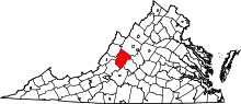 Location in the U.S. state of Virginia | ||
 Virginia's location in the U.S. | ||
| Founded | 1777 | |
| Named for | Natural Bridge | |
| Seat | Lexington | |
| Largest town | Lexington | |
| Area | ||
| • Total | 601 sq mi (1,557 km2) | |
| • Land | 598 sq mi (1,549 km2) | |
| • Water | 3.4 sq mi (9 km2), 0.6% | |
| Population (est.) | ||
| • (2015) | 22,354 | |
| • Density | 37/sq mi (14/km2) | |
| Congressional district | 6th | |
| Time zone | Eastern: UTC−5/−4 | |
| Website |
www | |

Rockbridge County is a county located in the Commonwealth of Virginia. As of the 2010 census, the population was 22,307.[1] Its county seat is Lexington.[2] The independent cities of Buena Vista (6,680) and Lexington (7,170) are both enclaved within the county's geographical borders.
History
Rockbridge County was established in October, 1777 from parts of now neighboring Augusta and Botetourt counties, and the first county elections were held in May 1778. Rockbridge County was named for Natural Bridge, a notable landmark in the southern portion of the county. Rockbridge County was formed during an act of assembly intended to reduce the amount of travel to the nearest courthouse, and to ensure trials were held fairly, and among friends rather than strangers. The first court session in Rockbridge County was held at the home of Samuel Wallace on April 7, 1778. Slaves were far fewer in Rockbridge County than in many parts of Virginia, and, thus, the anti-slavery movement was stronger in Rockbridge than in many other counties of Virginia. For instance, several faculty members at Washington College (now Washington and Lee University) vigorously opposed slavery. However, many of the wealthiest residents of Rockbridge County owned slaves and passed down those slaves to their widows and children.[3]
Cyrus McCormick invented the reaper near Steele's Tavern at the northern end of the county.
Geography
According to the U.S. Census Bureau, the county has a total area of 601 square miles (1,560 km2), of which 598 square miles (1,550 km2) is land and 3.4 square miles (8.8 km2) (0.6%) is water.[4]
Adjacent counties
|
|
Cities
National protected areas
- Blue Ridge Parkway (part)
- George Washington National Forest (part)
- Jefferson National Forest (part)
- United States National Radio Quiet Zone (part)
Major highways
Demographics
| Historical population | |||
|---|---|---|---|
| Census | Pop. | %± | |
| 1790 | 6,548 | — | |
| 1800 | 8,945 | 36.6% | |
| 1810 | 10,318 | 15.3% | |
| 1820 | 11,945 | 15.8% | |
| 1830 | 14,244 | 19.2% | |
| 1840 | 14,284 | 0.3% | |
| 1850 | 16,045 | 12.3% | |
| 1860 | 17,248 | 7.5% | |
| 1870 | 16,058 | −6.9% | |
| 1880 | 20,003 | 24.6% | |
| 1890 | 23,062 | 15.3% | |
| 1900 | 21,799 | −5.5% | |
| 1910 | 21,171 | −2.9% | |
| 1920 | 20,626 | −2.6% | |
| 1930 | 20,902 | 1.3% | |
| 1940 | 22,384 | 7.1% | |
| 1950 | 23,359 | 4.4% | |
| 1960 | 24,039 | 2.9% | |
| 1970 | 16,637 | −30.8% | |
| 1980 | 17,911 | 7.7% | |
| 1990 | 18,350 | 2.5% | |
| 2000 | 20,808 | 13.4% | |
| 2010 | 22,307 | 7.2% | |
| Est. 2016 | 22,392 | [5] | 0.4% |
| U.S. Decennial Census[6] 1790–1960[7] 1900–1990[8] 1990–2000[9] 2010–2013[1] | |||
As of the census[10] of 2000, there were 20,808 people, 8,486 households, and 6,075 families residing in the county. The population density was 35 people per square mile (13/km²). There were 9,550 housing units at an average density of 16 per square mile (6/km²). The racial makeup of the county was 95.42% White, 2.97% Black or African American, 0.26% Native American, 0.44% Asian, 0.12% from other races, and 0.78% from two or more races. 0.58% of the population were Hispanic or Latino of any race.
There were 8,486 households out of which 29.20% had children under the age of 18 living with them, 57.50% were married couples living together, 9.50% had a female householder with no husband present, and 28.40% were non-families. 23.90% of all households were made up of individuals and 9.90% had someone living alone who was 65 years of age or older. The average household size was 2.43 and the average family size was 2.84.
In the county, the population was spread out with 22.20% under the age of 18, 7.90% from 18 to 24, 27.20% from 25 to 44, 27.10% from 45 to 64, and 15.70% who were 65 years of age or older. The median age was 40 years. For every 100 females there were 100.40 males. For every 100 females age 18 and over, there were 98.00 males.
The median income for a household in the county was $36,035, and the median income for a family was $41,324. Males had a median income of $28,217 versus $19,946 for females. The per capita income for the county was $18,356. About 6.60% of families and 9.60% of the population were below the poverty line, including 9.40% of those under age 18 and 9.60% of those age 65 or over.
Media
- The Rockbridge Advocate (monthly magazine)
- Rockbridge Forum (free public web discussion by/for Rockbridge folk)
- The News-Gazette (weekly newspaper)
- The Rockbridge Report (weekly broadcast and website, Washington & Lee University journalism students)
- EyeOnVirginia.com (videos and interviews with Rockbridge area newsmakers)
Communities
The independent cities of Buena Vista and Lexington are separate political jurisdictions located within Rockbridge County. Lexington is the county seat (in spite of its independent status), and it shares three constitutional officers with Rockbridge County: Sheriff, Clerk of the Circuit Court and Commonwealth's Attorney. Buena Vista does not share constitutional officers with either Rockbridge County or Lexington.
Towns
Census-designated place
Other unincorporated communities
- Brownsburg
- Fairfield
- Natural Bridge Station
- Raphine
Notable people
- Robert H. Adams (1792–1832), born in Rockbridge County, United States Senator from Mississippi [11]
- John Allen (soldier) (1771–1813), born in Rockbridge County, a Kentucky political figure and colonel of militia, killed in the War of 1812
- Adam Rankin Alexander (1772–1851), born in Rockbridge County, United States Congressman from Tennessee[11]
- Archibald Alexander (1772–1851), born in Rockbridge County, noted Presbyterian clergyman, president of Hampden–Sydney College and one of the founders of and the first professor of Princeton Theological Seminary[11]
- Samuel Dale (1772–1841), born in Rockbridge County, American frontiersman, known as the ""Daniel Boone of Alabama" and a veteran of the Creek War of 1813–1814
- William C. Friday (1920–2012), American educator, public servant and President of University of North Carolina (1956–1986), born in Raphine, Rockbridge County.
- Sam Houston (1793–1863), born in Rockbridge County, the only man to be Governor of two U.S. states (Texas, Tennessee). Also, victor at the Battle of San Jacinto, President of the Republic of Texas, and U.S. Senator.
- Stonewall Jackson, General in the C.S.A. Army, lived in Lexington, the county seat.
- Robert E. Lee, former commander of the Confederate Army of Northern Virginia in the U.S. Civil War, who, after the war, accepted the presidency of Washington and Lee University (then Washington College)
- Cyrus McCormick, inventor of the reaper
- Sally Mann (born 1951), celebrated American photographer
- Charlie Manuel, American and Japanese baseball player and World Series champion manager of the Philadelphia Phillies
- Rick Mast, Fan favorite Winston Cup and Busch Series driver
- Samuel B. Pryor, (1816–1866), First mayor of Dallas, TX. He was in the first class of the Virginia Military Institute.
- Archibald Roane, who later became governor of Tennessee, lived in Rockbridge County in the 1780s
- Absalom Willis Robertson, U.S. Senator, father of Pat Robertson
- Pat Robertson (b. 1930), American minister, university president and media figure
- Archibald Stuart, Founder of Phi Beta Kappa
- Cy Twombly, American ex-patriate painter, born in Lexington
- Pierre Daura, Spanish/Catalan painter, naturalized American
Politics
| Year | Republican | Democratic | Third parties |
|---|---|---|---|
| 2016 | 61.9% 6,680 | 32.5% 3,508 | 5.6% 607 |
| 2012 | 58.0% 5,898 | 40.2% 4,088 | 1.9% 191 |
| 2008 | 56.2% 5,732 | 42.6% 4,347 | 1.1% 116 |
| 2004 | 59.0% 5,412 | 39.5% 3,627 | 1.6% 142 |
| 2000 | 57.8% 4,522 | 37.7% 2,953 | 4.5% 352 |
| 1996 | 45.0% 3,274 | 42.8% 3,116 | 12.2% 889 |
| 1992 | 43.0% 3,228 | 38.8% 2,908 | 18.2% 1,367 |
| 1988 | 58.4% 3,541 | 39.8% 2,412 | 1.8% 109 |
| 1984 | 65.7% 4,067 | 33.9% 2,098 | 0.5% 29 |
| 1980 | 49.0% 2,784 | 43.6% 2,475 | 7.4% 418 |
| 1976 | 43.7% 2,157 | 51.1% 2,525 | 5.2% 258 |
| 1972 | 74.3% 3,009 | 23.6% 956 | 2.1% 86 |
| 1968 | 56.8% 2,280 | 21.1% 845 | 22.2% 889 |
| 1964 | 45.8% 2,200 | 54.1% 2,599 | 0.2% 7 |
| 1960 | 60.5% 2,170 | 39.2% 1,405 | 0.3% 10 |
| 1956 | 66.5% 2,273 | 30.4% 1,039 | 3.1% 106 |
| 1952 | 65.9% 2,068 | 33.8% 1,059 | 0.4% 11 |
| 1948 | 46.5% 1,062 | 43.5% 994 | 10.0% 228 |
| 1944 | 36.9% 961 | 62.8% 1,638 | 0.4% 9 |
| 1940 | 35.6% 902 | 63.8% 1,618 | 0.6% 15 |
| 1936 | 34.5% 868 | 65.0% 1,635 | 0.5% 13 |
| 1932 | 31.0% 811 | 67.4% 1,764 | 1.7% 44 |
| 1928 | 47.9% 1,206 | 52.1% 1,311 | |
| 1924 | 31.9% 680 | 65.4% 1,394 | 2.7% 58 |
| 1920 | 43.3% 1,054 | 56.1% 1,365 | 0.5% 13 |
| 1916 | 36.2% 601 | 63.2% 1,049 | 0.7% 11 |
| 1912 | 26.8% 433 | 58.8% 949 | 14.4% 233 |
See also
References
- 1 2 "State & County QuickFacts". United States Census Bureau. Archived from the original on July 17, 2011. Retrieved January 5, 2014.
- ↑ "Find a County". National Association of Counties. Archived from the original on 2011-05-31. Retrieved 2011-06-07.
- ↑ See, e.g., Alfred L. Brophy & Douglas Thie, "'Land, Slaves, and Bonds': Trust and Probate in the Pre-Civil War Shenandoah Valley," West Virginia Law Review vol. 119 (2016):345. Archived 2018-02-08 at the Wayback Machine.
- ↑ "US Gazetteer files: 2010, 2000, and 1990". United States Census Bureau. 2011-02-12. Archived from the original on 2012-03-12. Retrieved 2011-04-23.
- ↑ "Population and Housing Unit Estimates". Archived from the original on May 29, 2017. Retrieved June 9, 2017.
- ↑ "U.S. Decennial Census". United States Census Bureau. Archived from the original on May 12, 2015. Retrieved January 5, 2014.
- ↑ "Historical Census Browser". University of Virginia Library. Archived from the original on August 16, 2012. Retrieved January 5, 2014.
- ↑ "Population of Counties by Decennial Census: 1900 to 1990". United States Census Bureau. Archived from the original on December 15, 2013. Retrieved January 5, 2014.
- ↑ "Census 2000 PHC-T-4. Ranking Tables for Counties: 1990 and 2000" (PDF). United States Census Bureau. Archived (PDF) from the original on December 18, 2014. Retrieved January 5, 2014.
- ↑ "American FactFinder". United States Census Bureau. Archived from the original on 2013-09-11. Retrieved 2011-05-14.
- 1 2 3 Who Was Who in America, Historical Volume, 1607–1896. Marquis Who's Who. 1967.
- ↑ Leip, David. "Dave Leip's Atlas of U.S. Presidential Elections". uselectionatlas.org. Archived from the original on 23 March 2018. Retrieved 7 May 2018.
External links
![]()
Places adjacent to Rockbridge County, Virginia | ||||||||||
|---|---|---|---|---|---|---|---|---|---|---|
| ||||||||||
Municipalities and communities of Rockbridge County, Virginia, United States | ||
|---|---|---|
| Towns | | |
| CDP | ||
| Unincorporated communities | ||
| Footnotes | ‡This populated place also has portions in an adjacent county or counties | |
