Northampton County, Virginia
| Northampton County, Virginia | ||
|---|---|---|
 Northampton County Courthouse Historic District | ||
| ||
 Location in the U.S. state of Virginia | ||
 Virginia's location in the U.S. | ||
| Founded | 1634 | |
| Seat | Eastville | |
| Largest town | Exmore | |
| Area | ||
| • Total | 795 sq mi (2,059 km2) | |
| • Land | 212 sq mi (549 km2) | |
| • Water | 584 sq mi (1,513 km2), 73.4% | |
| Population (est.) | ||
| • (2015) | 12,155 | |
| • Density | 15/sq mi (6/km2) | |
| Congressional district | 2nd | |
| Time zone | Eastern: UTC−5/−4 | |
| Website |
www | |

Northampton County is a county located in the Commonwealth of Virginia. As of the 2010 census, the population was 12,389.[1] Its county seat is Eastville.[2]
Northampton and Accomack Counties comprise the Eastern Shore of Virginia.
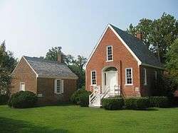
The county is the center of the late Eocene meteor strike that resulted in the Chesapeake Bay impact crater. The Northampton County Courthouse Historical District is part of the Eastville Historical District at the county seat.
History
When English colonists first arrived in the area in the early 1600s, the Virginia Eastern Shore region was governed by Debedeavon (aka "The Laughing King"), paramount chief of the Accawmacke clans who numbered around 2000 at the time. The former name of the county was Accomac Shire, one of the original eight shires of Virginia after the founding of the first settlement at Jamestown in 1607. In 1642, the name was changed to Northampton County by the English, to eliminate "heathen" names in the New World. In 1663, Northampton County was split into two counties that still exist today. The northern two-thirds took the original "Accomac" name (Accomack County), while the southern third to the Point Cape Charles remained as Northampton.
Slavery

Northampton County is notable for a colonial court case involving an indentured servant. The first free negro (a term used prior to the abolition of slavery) in North America was Anthony Johnson of Northampton County. Johnson was one of the first African-American to own land in America.[3]
In 1653, Johnson brought suit in Northampton County Court to argue that one of his servants, John Casor, was indentured to him for life. Casor had left him and was working for a neighbor.
The court ruled in Johnson's favor, making Northampton County the first jurisdiction to legally acknowledge that Negros could own slaves.[4] This court ruling decision also gives insight to how owners of indentured servants could easily choose to ignore the expiration of indentured contracts and force their servants into lifetime slavery. Although Casor, an African, had well-known white planters taking his part, he was reduced to lifetime slavery. Some planters sought more profitable methods of labor by taking advantage of Negro indentured servants, who had little recourse in the legal and social system to protect their rights.[5]
Geography
According to the U.S. Census Bureau, the county has a total area of 795 square miles (2,060 km2), of which 212 square miles (550 km2) is land and 584 square miles (1,510 km2) (73.4%) is water.[6]
Adjacent county and independent city
- Accomack County - north
- Virginia Beach, Virginia - south
National protected areas
Demographics
| Historical population | |||
|---|---|---|---|
| Census | Pop. | %± | |
| 1790 | 6,889 | — | |
| 1800 | 6,763 | −1.8% | |
| 1810 | 7,474 | 10.5% | |
| 1820 | 7,705 | 3.1% | |
| 1830 | 8,641 | 12.1% | |
| 1840 | 7,715 | −10.7% | |
| 1850 | 7,498 | −2.8% | |
| 1860 | 7,832 | 4.5% | |
| 1870 | 8,046 | 2.7% | |
| 1880 | 9,152 | 13.7% | |
| 1890 | 10,313 | 12.7% | |
| 1900 | 13,770 | 33.5% | |
| 1910 | 16,672 | 21.1% | |
| 1920 | 17,852 | 7.1% | |
| 1930 | 18,565 | 4.0% | |
| 1940 | 17,597 | −5.2% | |
| 1950 | 17,300 | −1.7% | |
| 1960 | 16,966 | −1.9% | |
| 1970 | 14,442 | −14.9% | |
| 1980 | 14,625 | 1.3% | |
| 1990 | 13,061 | −10.7% | |
| 2000 | 13,093 | 0.2% | |
| 2010 | 12,389 | −5.4% | |
| Est. 2016 | 12,139 | [7] | −2.0% |
| U.S. Decennial Census[8] 1790-1960[9] 1900-1990[10] 1990-2000[11] 2010-2013[1] | |||
As of the census[12] of 2010, there were 12,389 people, 5,321 households, and 3,543 families residing in the county. The population density was 63 people per square mile (24/km²). There were 6,547 housing units at an average density of 32 per square mile (12/km²). The racial makeup of the county was 57.9% White, 36.5% Black or African American, 0.2% Native American, 0.7% Asian, 0.1% Pacific Islander, 3.2% from other races, and 1.4% from two or more races. 7.1% of the population were Hispanic or Latino of any race.
The largest ancestry groups in Northampton County include: African American (36%), English American (15%), German (7%), Irish (6%) and Italian (3%)
There were 5,321 households out of which 25.70% had children under the age of 18 living with them, 45.30% were married couples living together, 17.50% had a female householder with no husband present, and 33.40% were non-families. 29.40% of all households were made up of individuals and 15.60% had someone living alone who was 65 years of age or older. The average household size was 2.39 and the average family size was 2.94.
In the county, the age distribution of the population shows 23.30% under the age of 18, 7.10% from 18 to 24, 23.60% from 25 to 44, 24.80% from 45 to 64, and 21.20% who were 65 years of age or older. The median age was 42 years. For every 100 females there were 87.90 males. For every 100 females age 18 and over, there were 84.10 males.
The median income for a household in the county was $28,276, and the median income for a family was $35,034. Males had a median income of $26,842 versus $21,839 for females. The per capita income for the county was $16,591. About 15.80% of families and 20.50% of the population were below the poverty line, including 29.20% of those under age 18 and 16.50% of those age 65 or over.
Northampton County is home to the United States' oldest continuous court records.
Transportation
Major highways
Education
Northampton County Public Schools operates public schools in the county.
Communities

- Belle Haven
- Cape Charles
- Cheriton
- Eastville
- Exmore
- Nassawadox
- Bayview (unincorporated)
- Oyster (unincorporated)
Politics
| Year | Republican | Democratic | Third parties |
|---|---|---|---|
| 2016 | 43.6% 2,686 | 52.8% 3,255 | 3.7% 227 |
| 2012 | 41.2% 2,676 | 57.6% 3,741 | 1.1% 74 |
| 2008 | 41.2% 2,713 | 57.7% 3,800 | 1.1% 73 |
| 2004 | 48.5% 2,669 | 50.5% 2,775 | 1.0% 55 |
| 2000 | 47.0% 2,299 | 47.8% 2,340 | 5.2% 253 |
| 1996 | 35.6% 1,763 | 51.9% 2,569 | 12.5% 616 |
| 1992 | 37.2% 2,088 | 45.7% 2,568 | 17.1% 962 |
| 1988 | 52.0% 2,562 | 45.5% 2,242 | 2.5% 123 |
| 1984 | 55.8% 2,906 | 42.8% 2,226 | 1.4% 75 |
| 1980 | 45.7% 2,165 | 49.8% 2,363 | 4.5% 215 |
| 1976 | 43.2% 2,043 | 51.9% 2,459 | 4.9% 233 |
| 1972 | 66.5% 2,587 | 32.0% 1,246 | 1.5% 60 |
| 1968 | 35.5% 1,410 | 35.7% 1,418 | 28.8% 1,146 |
| 1964 | 51.1% 1,586 | 48.9% 1,516 | 0.0% 1 |
| 1960 | 41.6% 995 | 58.0% 1,387 | 0.4% 10 |
| 1956 | 51.0% 1,264 | 45.7% 1,132 | 3.3% 81 |
| 1952 | 50.1% 1,307 | 49.4% 1,289 | 0.5% 12 |
| 1948 | 29.9% 525 | 56.7% 997 | 13.4% 236 |
| 1944 | 25.5% 381 | 74.2% 1,108 | 0.3% 4 |
| 1940 | 29.2% 359 | 70.5% 866 | 0.2% 3 |
| 1936 | 22.1% 277 | 77.7% 975 | 0.2% 3 |
| 1932 | 18.9% 298 | 80.2% 1,264 | 1.0% 15 |
| 1928 | 42.4% 688 | 57.6% 935 | |
| 1924 | 15.5% 180 | 81.2% 941 | 3.3% 38 |
| 1920 | 18.4% 217 | 81.0% 954 | 0.6% 7 |
| 1916 | 11.9% 109 | 87.2% 802 | 1.0% 9 |
| 1912 | 9.4% 83 | 81.9% 726 | 8.7% 77 |
Notable people
- Abel Upshur (1791-1844), born in Northampton County, United States Secretary of State and United States Secretary of the Navy[14]
- John Casor, the first person of African descent in England's Thirteen Colonies to be declared as a slave for life as the result of a civil suit.[15][16]
See also
References
- 1 2 "State & County QuickFacts". United States Census Bureau. Archived from the original on July 15, 2011. Retrieved January 4, 2014.
- ↑ "Find a County". National Association of Counties. Retrieved 2011-06-07.
- ↑ "Anthony Johnson". pbs.org. Retrieved 15 January 2018.
- ↑ Klein, Herbert S. (1967). Slavery In The Americas: A Comparative Study of Cuba and Virginia. University of Chicago Press.
- ↑ Foner, Philip S. (1980). "History of Black Americans: From Africa to the Emergence of the Cotton Kingdom". Oxford University Press. Archived from the original on 2013-10-14.
- ↑ "US Gazetteer files: 2010, 2000, and 1990". United States Census Bureau. 2011-02-12. Retrieved 2011-04-23.
- ↑ "Population and Housing Unit Estimates". Retrieved June 9, 2017.
- ↑ "U.S. Decennial Census". United States Census Bureau. Retrieved January 4, 2014.
- ↑ "Historical Census Browser". University of Virginia Library. Retrieved January 4, 2014.
- ↑ "Population of Counties by Decennial Census: 1900 to 1990". United States Census Bureau. Retrieved January 4, 2014.
- ↑ "Census 2000 PHC-T-4. Ranking Tables for Counties: 1990 and 2000" (PDF). United States Census Bureau. Retrieved January 4, 2014.
- ↑ "American FactFinder". United States Census Bureau. Retrieved 2011-05-14.
- ↑ Leip, David. "Dave Leip's Atlas of U.S. Presidential Elections". uselectionatlas.org. Retrieved 5 April 2018.
- ↑ "Abel Parker Upshur - People - Department History - Office of the Historian". history.state.gov. Retrieved 5 April 2018.
- ↑ Edgar Toppin (1973). The Black American in United States History, Allyn & Bacon. ISBN 9781475961720, p. 46
- ↑ William J. Wood, "The Illegal Beginning of American Slavery", ABA Journal, 1970, American Bar Association, accessed 2 May 2011
External links
Places adjacent to Northampton County, Virginia | ||||||||||
|---|---|---|---|---|---|---|---|---|---|---|
| ||||||||||
Municipalities and communities of Northampton County, Virginia, United States | ||
|---|---|---|
| Towns | | |
| Unincorporated communities |
| |
| Footnotes | ‡This populated place also has portions in an adjacent county or counties | |
