Interstate 64 in Virginia
| ||||
|---|---|---|---|---|
|
I-64 highlighted in red | ||||
| Route information | ||||
| Maintained by VDOT | ||||
| Length | 299.45 mi[1][2] (481.92 km) | |||
| Existed | 1957 – present | |||
| Major junctions | ||||
| West end |
| |||
|
| ||||
| East end |
| |||
| Location | ||||
| Counties | Allegheny, Rockbridge, Augusta, Nelson, Albemarle, Fluvanna, Louisa, Goochland, Henrico, New Kent, James City, York, City of Newport News, City of Hampton, City of Norfolk, City of Virginia Beach, City of Chesapeake | |||
| Highway system | ||||
| ||||

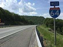
In the U.S. state of Virginia, Interstate 64 runs east–west through the middle of the state from West Virginia to the Hampton Roads region, a total of 299 miles (481 km). It is notable for crossing the mouth of the harbor of Hampton Roads on the Hampton Roads Bridge-Tunnel, the first bridge-tunnel to incorporate artificial islands. Also noteworthy is a section through Rockfish Gap, a wind gap in the Blue Ridge Mountains, which was equipped with an innovative system of airport-style runway lighting embedded into the pavement to aid motorists during periods of poor visibility due to fog or other conditions.
Route description
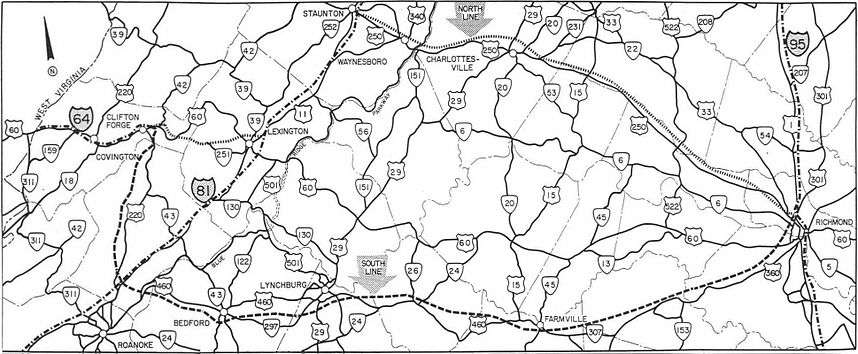
Alleghany County to Charlottesville
_in_Jolivue%2C_Augusta_County%2C_Virginia.jpg)
I-64 enters Virginia as a four-lane divided highway, continuing its concurrency with U.S. 60 through Covington into Lexington where the two routes split. From Lexington, I-64 then turns northward to Staunton overlapping Interstate 81 in the Shenandoah Valley. From Staunton, I-64 leaves I-81 and passes through Waynesboro and crosses Rockfish Gap and continues eastward, passing just to the south of Charlottesville, closely following the path of the historic colonial-era Three Notch'd Road, which had been established in the Colony of Virginia by the 1730s, and was largely replaced in the 1930s by U.S. Route 250.[3] Just outside of Charlottsville in Zion Crossroads, I-64 received the state's first diverging diamond interchange at its interchange with US 15, which opened to traffic on February 21, 2014, and completed on April 15, 2014.[4][5][6]
Greater Richmond and the Virginia Peninsula
After Charlottesville, I-64 then turns more east-southeasterly and heads towards Richmond, passing through Fluvanna, Goochland and Louisa Counties. After entering Henrico County, and the Richmond Metro area, Interstate 64 interchanges and overlaps with Interstate 95 on a stretch of highway which was a part of the former Richmond-Petersburg Turnpike, passing near Downtown Richmond and through the historic African-American neighborhood of Jackson Ward. Once on the southside of Downtown Richmond, I-64 diverges from its concurrency with I-95 and continues southeasterly down the Virginia Peninsula through New Kent County and the Historic Triangle, into Newport News.
This portion of I-64 was set up by VDOT with a contraflow lane reversal system in place in the event of a mass evacuation of the Hampton Roads area region due to a hurricane or other catastrophic event. Hurricane gates are installed at the eastbound Interstate 64 entrance and exit ramps from Exit 200 (Interstate 295) to Exit 273 (U.S. Route 60 east of the Hampton Roads Bridge-Tunnel), and crossover roads are in place near the aforementioned exits.[7] To date, there has never been an activation of the contraflow system in any capacity.
Hampton Roads Beltway
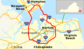
Shortly after entering its interchange with Denbigh Blvd (VA 173), I-64 enters Metro Hampton Roads and widens out to an eight-lane divided highway, continuing generally south-southeasterly into Hampton where it meets the northern terminus of Interstate 664 beginning the Inner Loop of the Hampton Roads Beltway. I-64 curves north-northeast to pass north of Downtown Hampton and cross the Hampton River, turning back southward to reach the Hampton Roads Bridge-Tunnel, which it utilizes to cross the main shipping channel at the entrance to the harbor of Hampton Roads from the Chesapeake Bay. Once on the Southside, I-64 turns south through Norfolk, passing the eastern boundary of Naval Station Norfolk and Chambers Field, and the spur route supplying it, Interstate 564. It then becomes a six lane divided highway with a two lane reversible roadway in the middle, which is used for HOV-traffic during morning and afternoon rush hours. It continues through Norfolk, curving multiple times and eventually ending up heading due south as it passes the interchange with another of its spur routes, Interstate 264 on the northwest side of Virginia Beach.
After I-264, there are no more directional markers on I-64 from here to its "eastern" terminus, because I-64 "east" will actually head west after its current southward course, and vice versa. From I-264 to its "eastern" terminus, it is simply only signed as I-64 and either the Inner and Outer loop of the Hampton Roads Beltway.
Shortly after the I-264 interchange, I-64 leaves Virginia Beach for the city of Chesapeake. It soon comes to a complex interchange between another of its spur routes, Interstate 464, along with SR 168 and U.S. 17. I-64, now running westward, crosses the Southern Branch of the Elizabeth River using the High Rise Bridge. The road then curves northwesterly and ends at Bowers Hill, where it meets both the western terminus of Interstate 264 and the southern terminus of Interstate 664 near the northeastern corner of the Great Dismal Swamp. I-64's lanes continue northbound as I-664 to Newport News across the Monitor-Merrimac Bridge Tunnel, ending at I-64 in Hampton, completing the beltway.
History
In early studies and proposals of the Interregional Highway System (the predecessor title of the Eisenhower Interstate System), I-64 was to use the U.S. Route 250 alignment west of Richmond.[8][9][10][11] However, in the late 1950s, a number of interested citizens including Virginia Senator Mosby G. Perrow, Jr., proposed that I-64 be realigned to run along U.S. Route 220, U.S. Route 460, State Route 307, and U.S. Route 360 from Clifton Forge via Cloverdale (near Roanoke), Lynchburg, and Farmville to Richmond. This southern route was favored by Gov. J. Lindsay Almond Jr. and most members of the State Highway Commission.
The decision was on hold for three years while the state continued planning for the piece of the US 250 alignment from Richmond to Short Pump, which would be needed anyway to handle traffic.[12] In 1961, U.S. Secretary of Commerce Luther Hodges rejected that plan and chose the present route, leaving Lynchburg as the largest city in Virginia not served by an interstate. Officially, the chosen route was considered more efficient. However, there is speculation that the decision involved "back-room" politics of the Kennedy administration.[13]
Auxiliary routes
Interstate 64 has four auxiliary routes, all of which are in the Hampton Roads Area:
- Interstate 664, a bypass route serving Chesapeake, Suffolk, Newport News and Hampton.
- Interstate 564, a spur route serving Naval Station Norfolk.
- Interstate 264, a bypass route serving the Virginia Beach Oceanfront, Downtown Norfolk and most of Portsmouth.
- Interstate 464, a connector route serving the western side of Chesapeake, Portsmouth and Downtown Norfolk. It connects I-64 in Chesapeake to I-264 in Norfolk.
Both of the bypass routes are shorter than the main leg for through traffic - I-664 is about 15 miles (24 km) shorter than the bypassed main leg while I-264 is about a mile (1.6 km) shorter than the main leg it bypasses.
Current & future projects
I-64 widening projects
Two segments on I-64 have been identified as candidates for widening: I-64 on the Virginia Peninsula from New Kent County to Newport News and I-64 in South Hampton Roads from the I-464/SR 168/U.S. 17 interchange in Chesapeake to the Bowers Hill Interchange in Suffolk.
Peninsula
On the Peninsula, most of the I-64 corridor is a four lane roadway and is one of the most-traveled segments in the region, connecting the Hampton Roads Metro to the Greater Richmond region. In recent years, the corridor has become a major bottleneck for traffic, with over half of the entire 75 mile stretch having failing or near failing levels of service and continued increased safety concerns.[14] In 2011, VDOT initiated a study that would consider widening the highway with either additional general purpose lanes in the median and/or on the outside shoulder, adding a two laned, fully reversible managed lanes (either as an tolled express lane or an HOT lane facility), or the addition of full tolling on the entire span.[15] The approved plan selected by VDOT and partners included the plan that added an additional general purpose lane in each direction by either expanding into the median or on the outside shoulder.[16] In June 2013, the Commonwealth Transportation Board (CTB) included $100 million in funding for the project in its Six-Year Improvement Program, allowing the project to move forward into the design and build phases. The Hampton Roads Transportation Planning Organization (HRTPO) allocated an additional $44 million to Segment I of the project to extend the boundaries beyond the Fort Eustis interchange.[17] The project is broken down into three operationally independent segments, which are independently funded, designed and built by a different company.
- Segment I encompassed the portion of I-64 beginning west of Route 143, Jefferson Avenue (Exit 255) to just east of Route 238, Yorktown Road (Exit 247). Construction on this segment began in September 2015 and was completed December 1, 2017.[17] It was managed by Shirley Contracting Company, LLC at a total cost of $122 million.
- Segment II begins 1.05 miles west of Route 199 (Humelsine Parkway/Marquis Center Parkway) near exit 242 and ends 0.54 miles east of Route 238 (Yorktown Road) near exit 247, where Segment I ends. Construction on this segment is managed by Alan Myers VA, LLC, and is expected to cost $138 million. Construction began in the fall of 2016 and is scheduled to be complete by spring 2019.[18]
- Segment III begins approximately 1.0 mile west of Route 199, Newman Road (Exit 234) to 1.05 miles west of Route 199, Humelsine Parkway/Marquis Center Parkway (Exit 242). No timeline has been set as of yet for this project.[19]
Southside
Similar to I-64 west of Newport News on the Peninsula, VDOT and the HRTPO undertook environmental and preliminary engineering studies for the improvement of the 8 mile, 48 year old corridor of the I-64 from Interstate 464 in Chesapeake to the Bowers Hill Interchange. This included replacing the functionally obsolete High Rise Bridge, which was completed one year after the study corridor opened, in 1969.
This study, completed in 2013, showed that the corridor frequently performed at near-failing levels of service (LOS grades D and E), with the High Rise Bridge itself outright failing, resulting in higher crash rates when compared to other areas in the region.[20] This is because most of the interchange ramps were built to previous interstate standards and were based on then-rural development in the Western Chesapeake and Eastern Suffolk.[21] In addition, since the start of tolling at the Elizabeth River Tunnels, the High Rise Bridge and the corridor has received a nearly 7% increase in traffic during peak hours, further exacerbating the problem.[22]
In March 2015, the CTB identified and approved of the addition of two lanes of capacity in each direction,[23] with the possibility of them being either 2 HOT lanes, 1 HOV & 1 general purpose lane or all four lanes being tolled. Widening would be accomplished by adding the lanes in the median east of U.S. 17 and to the outside shoulder west of U.S. 17.[24] The approved plan also calls for the construction of a new, four-lane 135 ft. fixed span bridge to the south of the current High Rise Bridge. Construction will be conducted in multiple phases, similar to the widening project on the Peninsula:
- The first phase of the project would widen I-64 to 3 lanes in each direction by adding the new lane to the median in both directions as a managed lane, begin the construction of the new High Rise Bridge, and replace and rehabilitate other existing bridges in the area. This segment is estimated to cost around $600 million.[25]
- The second phase would see all six lanes of I-64 shifted to the newly constructed bridge while the old bridge is demolished and replaced with a new four lane bridge that would eventually carry Inner Loop (I-64 West) traffic.
- The final phase would see the addition of the fourth lanes of traffic added to both directions and the shift of Inner Loop/I-64 West to the newly reconstructed bridge.
Once completed, the entire corridor would be an eight-lane stretch of highway, with two 135-ft fixed span bridges. Estimated costs for the entire project are currently estimated at $2.30 billion.[24] Currently, only part of first phase of the plan has been funded, which includes preliminary engineering and right of way service. A final design for the project is expected in December 2016, and a final contract award date is tentatively scheduled for August 2017.[26]
I-64 Express Lanes
State and regional leaders have come up to convert the region's 32 miles of existing high occupancy vehicle (HOV-2) lanes into high occupancy toll (HOT-2) lanes called the I-64 Express Lanes. According to a 2016 study by VDOT, only 1600 vehicles travel through the Norfolk HOV lanes during the morning HOV restriction (6-8am), and only 1300 vehicles through the lanes through Virginia Beach and Chesapeake.[27] The plans for the I-64 Express Lanes have been divided into individual segments, all of which have been endorsed by the regions transportation planning organization.
Segment 1: I-64 reversible roadway
Segment 1 will convert the 2 lane reversible roadway in Norfolk between the I-64/I-564 interchange and the I-64/I-264 interchange to HOT-2 lanes. Inner Loop traffic (eastbound from Hampton through Norfolk) would enter through the ramp just prior to the I-564 interchange, and exit through either the left exit directly to I-264 East, the slip ramp back to the Inner Loop for the interchange to I-264 West or continue straight into mainline Inner Loop on the other side of the interchange. Outer Loop (westbound from Chesapeake to Norfolk) traffic would enter the lanes at the ramp just after the I-64 Twin Bridges at the Elizabeth River, I-264 West traffic (from Virginia Beach to Downtown Norfolk) would use the flyover ramp from mainline I-264 to the Express Lanes, and I-264 East traffic (from Downtown Norfolk to Virginia Beach) would merge onto the Outer Loop and utilize the slip ramp entry. Tolling would only be operational from Monday - Friday from 5:00- 9:00 am and from 2pm to 6pm. Toll gantry installation is currently in progress, and the facility is scheduled to open in December 2017.[28]
Segment 2: Virginia Beach/Chesapeake & High Rise Bridge
Segment 2 would convert the single HOV-2 diamond lanes in each direction to HOT-2 lanes, and would also include the newly expanded High Rise Bridge and associated lanes of I-64 from the I-464/I-64 interchange. Both directions would have a primary entrance/exit near the Bowers Hill interchange, with a midpoint entrance/exit near the Greenbrier Parkway/Battlefield Boulevard interchanges and a terminal entrance/exit that ties in at the Twin Bridges. The current HOV lanes from be reduced from 16 feet to 12 feet (allowing the installation of the tubular road markers separating the general purpose lanes from the tolled express lanes), and new 12 foot lanes would be built extend across the I-64/I-464 interchange and be built into the new High Rise Bridge and all the way to the Bowers Hill interchange. These lanes would be operational 24 hours a day, 7 days a week once activated, and would be variably priced depending on the traffic in the general purpose lanes. This segment is scheduled to be completed as part of the High Rise Bridge project, which is scheduled for completion in 2021.[27]
Segment 3: Hampton Roads Bridge Tunnel
Segment 3 would be built as part of the Hampton Roads Bridge–Tunnel Expansion project, and would build from the existing reversible HOV northern termimus at I-564/I-64 through and across the expanded bridge-tunnel, and through the existing HOV-2 diamond lanes in Hampton. Planning for this segment (such as operational times and tolling pricing) will continue as the HRBT Expansion project continues and would open at the same time as the new HRBT opens, in 2024.[27]
Segment 4: I-64 on the Peninsula
Segment 4 would convert the remaining diamond lanes on I-64 in Hampton & Newport News to HOT-2 lanes as an extension of the HRBT Project. Detailed studies for this project, including operational hours, planning and design will occur in 2018, and would open along with the completion of the HRBT expansion.
Hampton Roads Bridge Tunnel Expansion
According to VDOT, in 1958, an average of 6,000 vehicles a day used the facility whereas an average of 88,000 vehicles a day were using the crossing in 2008, with volumes exceeding 100,000 during the tourist season, well exceeding the original design capacity of 77,000 vehicles per day, which sparked decades of debate on how to improve traffic flow at the region's most important water crossing. Studies into the growing traffic at the HRBT have roots back to the early 1990s. In 1992, the Virginia General Assembly had requested that VDOT study growing traffic at the HRBT. The conclusion of that study determined that a long-term large-scale solution to the problem would be required to alleviate backups. For the next fourteen years, VDOT would undertake numerous studies in 1999, 2008, 2012 and 2016, to help choose a candidate build that was financially and physically feasible to build.
After nearly two decades of studies and planning, the Commonwealth Transportation Board, and the two regional boards responsible for the project (HRTPO/HRTAC) voted unanimously in 2016 to a $3.3 billion expansion of the current bridge-tunnel and its approaches from four lanes to six lanes in both directions from the I-664 interchange to the I-564 interchange, with a new, three lane bridge tunnel built to carry traffic eastbound (Hampton to Norfolk). A Final Environmental Impact Study was published in May 2017, and the Record of Decision from the FHWA was granted in June. There is no current timeline for construction, however, HRTPO's Executive Director has stated that the project should be completed by 2024, while internal planning documents suggest no later than 2028.
Exit list
| County | Location | mi[1] | km | Exit | Destinations | Notes | ||
|---|---|---|---|---|---|---|---|---|
| Alleghany | | 0.00 | 0.00 | Continuation into West Virginia | ||||
| | 1.83 | 2.95 | 1 | Jerry's Run Trail | ||||
| | 7.16 | 11.52 | 7 | Eastbound exit, westbound entrance | ||||
| Callaghan | 10.01 | 16.11 | 10 | East end of US 60 overlap | ||||
| City of Covington | 14.84 | 23.88 | 14 | |||||
| Alleghany | Mallow | 16.68 | 26.84 | 16 | West end of concurrencies with US 60 and US 220; signed as exits 16A (US 60 / US 220) and 16B (WESTVACO Trailer Lot) westbound | |||
| | 21.49 | 34.58 | 21 | |||||
| Selma | 23.86 | 38.40 | 24 | |||||
| Cliftondale Park | 27.49 | 44.24 | 27 | East end of concurrency with US 220 | ||||
| | 29.27 | 47.11 | 29 | |||||
| Longdale Furnace | 35.65 | 57.37 | 35 | |||||
| Rockbridge | | 42.91 | 69.06 | 43 | ||||
| | 50.29 | 80.93 | 50 | East end of concurrency with US 60 | ||||
| East Lexington | 55.68 | 89.61 | 55 | |||||
| | 56.66 | 91.19 | 56 | I-81 exit 191; west end of concurrency with I-81 | ||||
| | 60.53 | 97.41 | 195 | Exit numbers follow I-81 | ||||
| Fairfield | 66.10 | 106.38 | 200 | |||||
| Raphine | 70.59 | 113.60 | 205 | |||||
| Augusta | Greenville | 78.62 | 126.53 | 213 | Split into exits 213A (south) and 213B (north) westbound | |||
| Mint Spring | 83.36 | 134.15 | 217 | |||||
| Jolivue | 85.83 | 138.13 | 220 | |||||
| 87.14 | 140.24 | 87 | I-81 exit 221; east end of concurrency with I-81; exit numbers follow I-64 | |||||
| Fishersville | 91.28 | 146.90 | 91 | |||||
| City of Waynesboro | 94.62 | 152.28 | 94 | |||||
| 96.57 | 155.41 | 96 | ||||||
| Augusta | Rockfish Gap | 99.58 | 160.26 | 99 | Access to the Blue Ridge Parkway and Skyline Drive | |||
| Nelson |
No major junctions | |||||||
| Albemarle | Yancey Mills | 107.22 | 172.55 | 107 | ||||
| | 114.13 | 183.67 | 114 | |||||
| | 118.38 | 190.51 | 118 | Signed as exits 118A (south) and 118B (north) | ||||
| | 119.87 | 192.91 | 120 | |||||
| | 121.60 | 195.70 | 121 | Signed as exits 121A (south) and 121B (north) eastbound | ||||
| City of Charlottesville | 122.15– 122.32 | 196.58– 196.85 | No major junctions | |||||
| Albemarle | | 124.32 | 200.07 | 124 | ||||
| | 129.74 | 208.80 | 129 | |||||
| Fluvanna |
No major junctions | |||||||
| Louisa | Zion Crossroads | 136.73 | 220.05 | 136 | Diverging diamond interchange | |||
| Ferncliff | 143.05 | 230.22 | 143 | |||||
| Goochland | Shannon Hill | 148.82 | 239.50 | 148 | ||||
| | 152.74 | 245.81 | 152 | |||||
| Louisa | Gum Spring | 159.43 | 256.58 | 159 | ||||
| Goochland | Oilville | 167.31 | 269.26 | 167 | ||||
| | 173.87 | 279.82 | 173 | |||||
| | 175.06 | 281.73 | 175 | |||||
| Henrico | Short Pump | 177.98 | 286.43 | 177 | I-295 exit 53; left exit eastbound; trumpet interchange | |||
| | 178.85 | 287.83 | 178 | Signed as exits 178A (west) and 178B (east) | ||||
| | 180.28 | 290.13 | 180 | Gaskins Road | Signed as exits 180A (south) and 180B (north) | |||
| | 181.67 | 292.37 | 181 | Parham Road | Signed as exits 181A (south) and 181B (north) westbound | |||
| | 183.70 | 295.64 | 183 | Signed as exits 183A (Glenside Drive south), 183B (US 250 east), and 183C (US 250 west / Glenside Drive north) westbound | ||||
| Dumbarton | 185.73 | 298.90 | 185 | Signed as exits 185A (Dickens Road to US 33 west) and 185B (east) eastbound | ||||
| City of Richmond | 187.07 | 301.06 | 186 | Eastbound exit to and westbound entrance from Laburnum Avenue | ||||
| 187.31 | 301.45 | 187 | I-95 exit 79; west end of concurrency with I-95 | |||||
| 188.14 | 302.78 | 78 | Exit number follows I-95 | |||||
| 190.33 | 306.31 | 76B | Exit number follows I-95; no westbound exit | |||||
| 190.56 | 306.68 | 76A | Chamberlayne Avenue (US 1 / US 301 north) | Exit number follows I-95; westbound exit and eastbound entrance | ||||
| 190.86 | 307.16 | 190 | I-95 exit 75; east end of concurrency with I-95; eastbound exit is for 3rd Street; westbound exit is for 5th Street; eastbound and westbound entrances are from 7th Street | |||||
| 192.53 | 309.85 | 192 | ||||||
| Henrico | | 193.89 | 312.04 | 193 | Signed as exits 193A (west) and 193B (east) | |||
| Montrose | 196.03 | 315.48 | 195 | Laburnum Avenue | ||||
| Sandston | 197.91 | 318.51 | 197 | Signed as exits 197A (south) and 197B (north) | ||||
| | 201.98 | 325.06 | 200 | I-295 exit 28 | ||||
| New Kent | Bottoms Bridge | 206.01 | 331.54 | 205 | West end of concurrency with SR 33 | |||
| | 211.44 | 340.28 | 211 | |||||
| | 214.91 | 345.86 | 214 | |||||
| | 220.60 | 355.02 | 220 | East end of concurrency with SR 33 | ||||
| James City | | 227.34 | 365.87 | 227 | ||||
| | 231.62 | 372.76 | 231 | Signed as exits 231A (Norge) and 231B (Croaker) | ||||
| York | | 234.46 | 377.33 | 234 | Signed as exits 234A (SR 199) and 234B (SR 646) westbound | |||
| | 239.17 | 384.91 | 238 | |||||
| | 242.61 | 390.44 | 242 | Signed as exits 242A (west) and 242B (east) | ||||
| | 244.23 | 393.05 | 243 | Split into exits 243A (US 60) and 243B (SR 143); no access to eastbound SR 143 or from SR 143 | ||||
| James City | | 246.86 | 397.28 | 247 | Exit ramp from eastbound I-64 to SR 143 and entrance ramps from eastbound SR 143 to eastbound I-64 and from westbound SR 143 to westbound I-64 | |||
| City of Newport News | 248.48 | 399.89 | Westbound exit, eastbound entrance | |||||
| 250.52 | 403.17 | 250 | Signed as exits 250A (west) and 250B (east) | |||||
| 255.55 | 411.27 | 255 | Signed as exits 255A (east) and 255B (west) | |||||
| 256.96 | 413.54 | 256 | Signed as exits 256A (west) and 256B (east) | |||||
| 258.77 | 416.45 | 258 | Signed as exits 258A (south) and 258B (north) | |||||
| City of Hampton | 261.80 | 421.33 | 261 | Hampton Roads Center Parkway | No access from westbound I-64 to eastbound Hampton Roads Center Parkway or from westbound Hampton Roads Center Parkway to eastbound I-64; signed as exits 261A (west) and 261B (east) eastbound | |||
| 263.13 | 423.47 | 262 | Westbound exit, eastbound entrance; west end of concurrency with SR 134; signed as exit 262B | |||||
| 263.65 | 424.30 | 263 | East end of concurrency with SR 134; signed as exits 263A (US 258 south) and 263B (US 258 north / SR 134 south) westbound | |||||
| 264.84 | 426.22 | 264 | I-664 exit 1; I-64 joins Hampton Roads Beltway | |||||
| 265.61 | 427.46 | 265 | Signed as exits 265A (La Salle Avenue south / SR 134 east, latter westbound only), 265B (La Salle Avenue north / SR 134 west, westbound only), and 265C (SR 134, eastbound only) | |||||
| 268.12 | 431.50 | 267 | West end of concurrency with US 60 | |||||
| 268.45 | 432.03 | 268 | ||||||
| Hampton Roads | Hampton Roads Bridge–Tunnel | |||||||
| City of Norfolk | 272.54 | 438.61 | 272 | West Ocean View Avenue – Willoughby Spit | ||||
| 274.28 | 441.41 | 273 | East end of US 60 overlap | |||||
| 275.58 | 443.50 | 274 | Bay Avenue – Naval Station | Westbound exit and eastbound entrance | ||||
| 276.98 | 445.76 | 276 | Signed as exits 276A (US 460), 276B (I-564), and 276C (SR 165) westbound; no access from eastbound I-64 to eastbound US 460; no direct access from westbound I-64 to westbound US 460; no direct access from eastbound I-64 to SR 165 or from SR 165 to westbound I-64 | |||||
| 278.36 | 447.98 | 277 | Signed as exits 277A (south) and 277B (north) | |||||
| 279.40 | 449.65 | 278 | No access from eastbound I-64 to northbound SR 194, from westbound I-64 to southbound SR 194, from northbound SR 194 to eastbound I-64, or from southbound SR 194 to westbound I-64 | |||||
| 280.40 | 451.26 | 279 | Signed as exits 279A (west) and 279B (east) westbound | |||||
| 281.66 | 453.29 | 281 | Signed as exits 281A (Robin Hood Road) and 281B (SR 165 south) eastbound; no eastbound entrance | |||||
| 282.85 | 455.20 | 282 | No access from eastbound I-64 to southbound US 13 or from northbound US 13 to westbound I-64 | |||||
| 284.59 | 458.00 | 284 | I-264 exit 14; signed as exits 284A (west) and 284B (east); eastbound exit 284A includes a flyover to I-264 east, so exit 284B is signed only for Newtown Road in that direction; east end of directional (east–west) signage; I-64 east is signed as inner loop (clockwise) and I-64 west is signed as outer loop (counterclockwise) | |||||
| City of Virginia Beach | 287.28 | 462.33 | 286 | Indian River Road | Signed as exits 286A (west) and 286B (east) | |||
| City of Chesapeake | 289.83 | 466.44 | 289 | Greenbrier Parkway | Signed as exits 289A (north) and 289B (south) | |||
| 291.96 | 469.86 | 290 | Outer loop end of concurrency with SR 168 | |||||
| 292.52 | 470.77 | 291 | I-464 exit 1; SR 168 exit 15A; no access from outer loop I-64 to southbound US 17; signed as exits 291A (I-464) and 291B (US 17 / SR 168); inner loop end of concurrency with SR 168; outer loop end of concurrency with US 17; signed as exits 291B (SR 168) and 292 (US 17) counterclockwise (outer) | |||||
| 293.25 | 471.94 | 292 | Outer loop exit only | |||||
| High Rise Bridge over Southern Branch Elizabeth River | ||||||||
| 296.85 | 477.73 | 296 | Inner loop end of US 17 overlap; signed as exits 296A (north) and 296B (south) on inner loop | |||||
| 298.31 | 480.08 | 297 | ||||||
| 300.62 | 483.80 | 299 | Eastern terminus of I-64; I-264 exit 1; I-664 exit 15; western terminus of I-264; southern terminus of I-664; signed as exits 299A (I-264) and 299B (I-664); Hampton Roads Beltway continues on I-664 | |||||
1.000 mi = 1.609 km; 1.000 km = 0.621 mi
| ||||||||
References
- 1 2 Staff (2014). "2014 Traffic Data". Virginia Department of Transportation. Retrieved 2015-09-14.
- Alleghany County and City of Covington (PDF)
- Rockbridge County, City of Lexington, and City of Buena Vista (PDF)
- Augusta County, City of Staunton, and City of Waynesboro (PDF)
- Nelson County (PDF)
- Albemarle County and City of Charlottesville (PDF)
- Fluvanna County (PDF)
- Louisa County (PDF)
- Goochland County (PDF)
- Henrico County (PDF)
- Chesterfield County, City of Richmond, and City of Colonial Heights (PDF)
- New Kent County (PDF)
- James City County and City of Williamsburg (PDF)
- York County and City of Poquoson (PDF)
- City of Newport News (PDF)
- City of Hampton (PDF)
- City of Norfolk, City of Portsmouth, and City of Chesapeake (PDF)
- City of Virginia Beach (PDF)
- ↑ "Main Routes of the Dwight D. Eisenhower National System Of Interstate and Defense Highways as of October 31, 2002". Retrieved 1 October 2014.
- ↑ "The Route of the Three Notch'd Road: A Preliminary Report" (PDF). Virginia Highway & Transportation Research Council. September 2003. Retrieved 2013-01-28.
- ↑ "Under Construction: I-64 Interchange at Route 15, Zion Crossroads". Virginia Department of Transportation. Retrieved November 5, 2013.
- ↑ "VDOT Opens new DDI" (PDF). VDOT. Retrieved 2014-03-11.
- ↑ "Animation of Traffic Flows". VDOT. Retrieved 2014-03-11.
- ↑ Richmond Times-Dispatch, Va. prepares for hurricanes Archived 2005-11-21 at the Wayback Machine., April 30, 2006
- ↑ State Highway Commission of Virginia (September 11, 1945). Minutes of Meeting (PDF) (Report). Richmond, VA: Commonwealth of Virginia. Page 12
- ↑ Routes of the Recommended Interregional Highway System, ca. 1943
- ↑ National System of Interstate Highways, August 2, 1947
- ↑ National System of Interstate and Defense Highways, September 1955
- ↑ State Highway Commission of Virginia (April 24, 1958). Minutes of Meeting (PDF) (Report). Richmond, VA: Commonwealth of Virginia. Page 23
- ↑ See: Charlottesville won, and Lynchburg lost / Routing of I-64 was major tussle, Richmond Times-Dispatch, 1999
- ↑ "WHY ARE IMPROVEMENTS TO I-64 NEEDED?" (pdf). Virginia Department of Transportation. April 2012.
- ↑ "Interstate 64 Peninsula Study (I-64 Corridor from I-95 in Richmond to I-664 in Hampton)". www.virginiadot.org. Retrieved 2016-05-29.
- ↑ "I-64 Final EIS Executive Summary" (PDF). Virginia Department of Transportation and Federal Highway Administration. December 2013.
- 1 2 "Interstate 64 Widening - Segment 1". www.i64widening.org. Retrieved 2016-05-29.
- ↑ "Interstate 64 Widening - Segment 2". www.i64widening.org. Retrieved 2016-05-29.
- ↑ "Interstate 64 Widening - Segment 3". www.i64widening.org. Retrieved 2016-05-29.
- ↑ http://www.virginiadot.org/projects/resources/hampton_roads/64HighRiseDocuments/Traffic_and_Transportation_Technical_Report.pdf
- ↑ http://www.vdot.virginia.gov/projects/resources/hampton_roads/UPC_104366_I64_Draft_EA_10032014.pdf
- ↑ http://hrtpo.org/uploads/docs/TRB%20Paper%20Analyzing%20the%20Impact%20of%20Implementing%20New%20Tolls%20on%20Existing%20Roadway%20Facilities%20Revised.pdf
- ↑ http://www.virginiadot.org/VDOT/Projects/Hampton_Roads/asset_upload_file31_80998.pdf
- 1 2 http://www.virginiadot.org/projects/resources/hampton_roads/64HighRiseDocuments/Eight_Lane_Build_-_Managed_Alternative.pdf
- ↑ Hafner, Katherine. "Dozens question VDOT officials about High-Rise Bridge".
- ↑ "I-64 Southside & High Rise Bridge Phased Construction". www.virginiadot.org. Retrieved 2016-07-16.
- 1 2 3 Gibson, Anthony (June 1, 2016), I-64 HOV to HOT Conversion Feasibility Study (PDF), Virginia Department of Transportation
- ↑ "64 Express Lanes: FAQs". www.64expresslanes.org. Retrieved 2017-07-21.
External links
Route map:
| Wikimedia Commons has media related to Interstate 64 in Virginia. |
| Previous state: West Virginia |
Virginia | Next state: Terminus |
| Surface roadways |
| ||||||||
|---|---|---|---|---|---|---|---|---|---|
| Water crossings |
| ||||||||
| Aviation, rail and transit services |
| ||||||||
| Planned projects |
| ||||||||