Isle of Wight County, Virginia
| Isle of Wight County, Virginia | ||
|---|---|---|
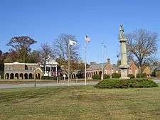 The 1800 courthouse at Isle of Wight Courthouse | ||
| ||
 Location in the U.S. state of Virginia | ||
 Virginia's location in the U.S. | ||
| Founded | 1634 | |
| Named for | Isle of Wight | |
| Seat | Isle of Wight | |
| Largest town | Smithfield | |
| Area | ||
| • Total | 363 sq mi (940 km2) | |
| • Land | 316 sq mi (818 km2) | |
| • Water | 47 sq mi (122 km2), 13.0% | |
| Population (est.) | ||
| • (2015) | 36,314 | |
| • Density | 100/sq mi (40/km2) | |
| Congressional district | 3rd | |
| Time zone | Eastern: UTC−5/−4 | |
| Website |
www | |

Isle of Wight County is a county located in the Hampton Roads region of the U.S. state of Virginia. It was named after the Isle of Wight, in the English Channel, from where many of its early colonists had come.[1] As of the 2010 census, the population was 35,270.[2] Its county seat is Isle of Wight.[3]
Isle of Wight County is located in the Virginia Beach-Norfolk-Newport News, VA-NC Metropolitan Statistical Area. Its northeastern boundary is on the coast of Hampton Roads waterway.
Isle of Wight County features two incorporated towns, Smithfield and Windsor. The first courthouse for the county was built in Smithfield in 1750. The original courthouse and its associated tavern (The Smithfield Inn) are still standing.
As the county population developed, leaders thought they needed a county seat near the center of the area. They built a new courthouse near the center of the county in 1800. The 1800 brick courthouse and its associated tavern (Boykin's Tavern) are still standing, as are the 1822 clerk's offices nearby. Some additions have been made. The 1800 courthouse is used daily, serving as the government chambers for the Board of Supervisors, as well as the meeting hall for the School Board. The chambers are sometimes used as a court for civil trials if the new courthouse is fully in use. The new courthouse opened in 2010; it is across the street from the sheriff's office and county offices complex.
History
During the 17th century, shortly after establishment of the settlement at Jamestown in 1607, English settlers explored and began settling the areas adjacent to the large Hampton Roads waterway. Captain John Smith in 1608 crossed the James River and obtained fourteen bushels of corn from the Native American inhabitants, the Warrosquyoack or Warraskoyak. They were a tribe of the Powhatan Confederacy, who had three towns in the area of modern Smithfield. English colonists drove the Warraskoyak from their villages in 1622 and 1627, as part of their reprisals for the Great Massacre of 1622, in which the Native Americans had decimated English settlements, hoping to drive them out of their territory.
The first English plantations along the south shore within present-day Isle of Wight were established by Puritan colonists, beginning with that of Christopher Lawne in May 1618. Several members of the Puritan Bennett family also settled there, including Richard Bennett. He led the Puritans to neighboring Nansemond in 1635, and later was appointed as governor of the Virginia Colony.
By 1634, the entire Colony consisted of eight shires or counties with a total population of approximately 5,000 inhabitants. Warrosquyoake Shire was renamed in 1637 as Isle of Wight County, after the island off the south coast of England. The original name had come derived from the Native Americans of the area; it went through transliteration and Anglicisation, eventually becoming known as "Warwicke Squeake".
St. Luke's Church , built in the 17th century, is Virginia's oldest church building.[4] In the late 20th century, it was designated as a National Historic Landmark in recognition of its significance. Many landmark and contributing structures on the National Register are located in Smithfield including the Wentworth-Grinnan House.
In 1732 a considerable portion of the northwestern part of the original shire was added to Brunswick County, and in 1748 the entire county of Southampton was carved out of it.
During the American Civil War, Company F of the 61st Virginia Infantry Regiment of the Confederate Army was called the "Isle of Wight Avengers."
Geography
According to the U.S. Census Bureau, the county has a total area of 363 square miles (940 km2), of which 316 square miles (820 km2) is land and 47 square miles (120 km2) (13.0%) is water.[5]
The county is bounded by the James River on the north and the Blackwater River to the south. The land is generally low-lying, with many swamps and pocosins.
Adjacent counties and independent cities
- Newport News, Virginia — northeast
- Suffolk, Virginia — southeast
- Southampton County — west
- Franklin, Virginia — southwest
- Surry County — northwest
Major highways
Demographics
| Historical population | |||
|---|---|---|---|
| Census | Pop. | %± | |
| 1790 | 9,028 | — | |
| 1800 | 9,342 | 3.5% | |
| 1810 | 9,186 | −1.7% | |
| 1820 | 10,139 | 10.4% | |
| 1830 | 10,517 | 3.7% | |
| 1840 | 9,972 | −5.2% | |
| 1850 | 9,353 | −6.2% | |
| 1860 | 9,977 | 6.7% | |
| 1870 | 8,320 | −16.6% | |
| 1880 | 10,572 | 27.1% | |
| 1890 | 11,313 | 7.0% | |
| 1900 | 13,102 | 15.8% | |
| 1910 | 14,929 | 13.9% | |
| 1920 | 14,433 | −3.3% | |
| 1930 | 13,409 | −7.1% | |
| 1940 | 13,381 | −0.2% | |
| 1950 | 14,906 | 11.4% | |
| 1960 | 17,164 | 15.1% | |
| 1970 | 18,285 | 6.5% | |
| 1980 | 21,603 | 18.1% | |
| 1990 | 25,503 | 18.1% | |
| 2000 | 29,728 | 16.6% | |
| 2010 | 35,270 | 18.6% | |
| Est. 2016 | 36,596 | [6] | 3.8% |
| U.S. Decennial Census[7] 1790-1960[8] 1900-1990[9] 1990-2000[10] 2010-2015[2] | |||
As of the census[11] of 2010, there were 35,270 people, 11,319 households, and 8,670 families residing in the county. The population density was 94 people per square mile (36/km²). There were 12,066 housing units at an average density of 38 per square mile (15/km²). The racial makeup of the county was 71.8% White, 24.7% Black or African American, 0.4% Native American, 0.8% Asian, 0.0% Pacific Islander, 0.5% from other races, and 1.8% from two or more races. 1.9% of the population were Hispanic or Latino of any race.
There were 11,319 households out of which 34.00% had children under the age of 18 living with them, 60.40% were married couples living together, 12.20% had a female householder with no husband present, and 23.40% were non-families. 20.00% of all households were made up of individuals and 8.60% had someone living alone who was 65 years of age or older. The average household size was 2.61 and the average family size was 2.99.
In the county, the population was spread out with 25.40% under the age of 18, 6.60% from 18 to 24, 29.60% from 25 to 44, 26.20% from 45 to 64, and 12.20% who were 65 years of age or older. The median age was 39 years. For every 100 females there were 95.70 males. For every 100 females age 18 and over, there were 91.70 males.
The median income for a household in the county was $45,387, and the median income for a family was $52,597. Males had a median income of $37,853 versus $22,990 for females. The per capita income for the county was $20,235. About 6.60% of families and 8.30% of the population were below the poverty line, including 8.80% of those under age 18 and 11.90% of those age 65 or over.
Government
Board of Supervisors
- Carrsville District: Don Rosie (I)
- Hardy District: Rudolph Jefferson (I)
- Newport District: William McCarty (I)
- Smithfield District: Dick Grice (I)
- Windsor District: Joel Acree (I)
Constitutional officers
- Clerk of the Circuit Court: Sharon Nelms Jones (I)
- Commissioner of the Revenue: Gerald H. Gwaltney (I)
- Commonwealth's Attorney: Georgette Phillips (I)
- Sheriff: Mark A. Marshall (I)
- Treasurer: Judith Crocker Wells (I)
State & federal elected officials
House of Delegates:
- Emily Brewer (R-64)
- Roslyn Tyler (D-75)
Senate:
- Tommy Norment (R-3)
- L. Louise Lucas (D-18)
U.S. House of Representatives:
- Bobby Scott (politician) (D-VA 3)
| Year | Republican | Democratic | Third parties |
|---|---|---|---|
| 2016 | 57.9% 12,204 | 37.4% 7,881 | 4.7% 990 |
| 2012 | 56.7% 11,802 | 42.1% 8,761 | 1.3% 264 |
| 2008 | 56.3% 11,258 | 42.9% 8,573 | 0.8% 166 |
| 2004 | 62.6% 9,929 | 37.0% 5,871 | 0.5% 71 |
| 2000 | 58.6% 7,587 | 39.9% 5,162 | 1.6% 201 |
| 1996 | 47.6% 5,416 | 43.6% 4,952 | 8.8% 1,001 |
| 1992 | 47.2% 5,370 | 38.5% 4,380 | 14.4% 1,637 |
| 1988 | 60.1% 5,779 | 39.0% 3,747 | 1.0% 95 |
| 1984 | 60.2% 5,664 | 38.8% 3,650 | 1.0% 98 |
| 1980 | 45.3% 3,526 | 50.8% 3,951 | 3.9% 307 |
| 1976 | 38.8% 2,718 | 59.1% 4,145 | 2.1% 146 |
| 1972 | 59.3% 3,555 | 38.4% 2,305 | 2.3% 138 |
| 1968 | 23.3% 1,312 | 35.1% 1,977 | 41.6% 2,346 |
| 1964 | 39.5% 1,737 | 60.4% 2,656 | 0.1% 6 |
| 1960 | 35.9% 1,141 | 63.6% 2,020 | 0.5% 16 |
| 1956 | 47.1% 1,298 | 48.0% 1,324 | 4.9% 135 |
| 1952 | 44.5% 996 | 54.9% 1,227 | 0.6% 14 |
| 1948 | 27.8% 442 | 66.9% 1,064 | 5.3% 85 |
| 1944 | 26.7% 430 | 73.3% 1,178 | |
| 1940 | 15.5% 208 | 84.6% 1,138 | |
| 1936 | 16.8% 207 | 83.0% 1,025 | 0.2% 3 |
| 1932 | 22.3% 284 | 77.0% 982 | 0.7% 9 |
| 1928 | 51.1% 555 | 48.9% 531 | |
| 1924 | 23.0% 190 | 76.3% 631 | 0.7% 6 |
| 1920 | 24.4% 245 | 75.5% 759 | 0.1% 1 |
| 1916 | 17.1% 140 | 82.8% 679 | 0.1% 1 |
| 1912 | 8.5% 75 | 80.1% 708 | 11.4% 101 |
Public services
Blackwater Regional Library is the regional library system that provides services to the citizens of Isle of Wight.
Communities
Towns
Census-designated places
Other unincorporated communities
- Battery Park
- Burwell's Bay
- Central Hill
- Comet
- Indika
- Isle of Wight
- Lawson
- Mogart's Beach
- Pons
- Raynor
- Rescue
- Stott
- Walters
- Wills Corner
- Zuni
Gallery
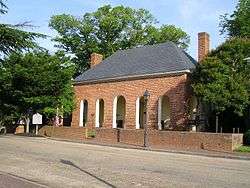 The 1750 courthouse on Main Street in Smithfield.
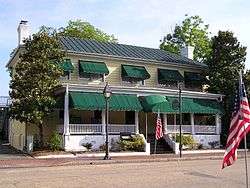 The 1752 tavern on Main Street, now operated as the Smithfield Inn.
 Boykin's Tavern, next to the 1800 courthouse.
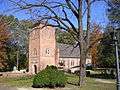 St. Luke's Church, built circa 1632.
See also
References
- ↑ Gannett, Henry (1905). The Origin of Certain Place Names in the United States. Govt. Print. Off. p. 167.
- 1 2 "State & County QuickFacts". United States Census Bureau. Archived from the original on July 12, 2011. Retrieved January 3, 2014.
- ↑ "Find a County". National Association of Counties. Archived from the original on 2011-05-31. Retrieved 2011-06-07.
- ↑ "Archived copy". Archived from the original on 2007-05-05. Retrieved 2007-05-28. , Historic St. Luke's website
- ↑ "US Gazetteer files: 2010, 2000, and 1990". United States Census Bureau. 2011-02-12. Archived from the original on 2012-03-12. Retrieved 2011-04-23.
- ↑ "Population and Housing Unit Estimates". Archived from the original on May 29, 2017. Retrieved June 9, 2017.
- ↑ "U.S. Decennial Census". United States Census Bureau. Archived from the original on May 12, 2015. Retrieved January 3, 2014.
- ↑ "Historical Census Browser". University of Virginia Library. Archived from the original on August 16, 2012. Retrieved January 3, 2014.
- ↑ "Population of Counties by Decennial Census: 1900 to 1990". United States Census Bureau. Archived from the original on December 15, 2013. Retrieved January 3, 2014.
- ↑ "Census 2000 PHC-T-4. Ranking Tables for Counties: 1990 and 2000" (PDF). United States Census Bureau. Archived (PDF) from the original on December 18, 2014. Retrieved January 3, 2014.
- ↑ "American FactFinder". United States Census Bureau. Archived from the original on 2013-09-11. Retrieved 2011-05-14.
- ↑ Leip, David. "Dave Leip's Atlas of U.S. Presidential Elections". uselectionatlas.org. Archived from the original on 2018-03-23.
External links
- Isle of Wight County Virginia official website
- Isle of Wight County Virginia Facebook
- Isle of Wight County Virginia Economic Development official website
- Hampton Roads Economic Development Alliance - serving Isle of Wight County
- Isle of Wight County Sheriff's Office Facebook
- Isle of Wight County Sheriff's Office web page
Places adjacent to Isle of Wight County, Virginia | ||||||||||
|---|---|---|---|---|---|---|---|---|---|---|
| ||||||||||
Municipalities and communities of Isle of Wight County, Virginia, United States | ||
|---|---|---|
| Towns | | |
| CDPs | ||
| Unincorporated communities | ||
