Warren County, Virginia
| Warren County, Virginia | ||
|---|---|---|
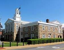 Warren County Courthouse in Front Royal, Virginia | ||
| ||
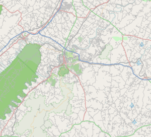
 Location in the U.S. state of Virginia | ||
 Virginia's location in the U.S. | ||
| Founded | 1836 | |
| Named for | Joseph Warren | |
| Seat | Front Royal | |
| Largest town | Front Royal | |
| Area | ||
| • Total | 217 sq mi (562 km2) | |
| • Land | 213 sq mi (552 km2) | |
| • Water | 3.3 sq mi (9 km2), 1.5% | |
| Population (est.) | ||
| • (2017) | 39,563 | |
| • Density | 186/sq mi (72/km2) | |
| Congressional district | 6th | |
| Time zone | Eastern: UTC−5/−4 | |
| Website |
www | |

Warren County is a U.S. county located in the Commonwealth of Virginia. The 2010 census places Warren County within the Washington-Arlington-Alexandria, DC-VA-MD-WV Metropolitan Statistical Area with a population of 37,575.[1] The county seat is Front Royal.[2]
History
By 1672 the entire Shenandoah Valley was claimed for hunting by the Iroquois Confederation following the Beaver Wars. Some bands of the Shawnee settled in the area as client groups to the Iroquois and alternately to the Cherokee after 1721. The Iroquois formally sold their entire claim east of the Alleghenies to the Virginia Colony at the Treaty of Lancaster in 1744.[3] Warren County was established in 1836 from Frederick and Shenandoah counties.[4]:33 At that time the county had a population of 7,000 people, a quarter of which were enslaved.[4]:289 Wedding records show marriages of people born in the 1770s marrying in the 1800s who head households of four to eight "free colored" so the early demographics of the population are unclear.[5]:823–824 Joist Hite lead the Sixteen Families into the Lower Shenandoah Valley.[6] Some consider that group the first European settlers of the area, others believe different claims.[6]:ix Either way, Presbyterians of Scotch-Irish lineage and Quakers followed.[7]
Rail service was established in 1854 with the construction of the Alexandria, Orange and Manassas Gap Railroad between Manassas and Riverton. This line was soon extended to Strasburg in time to become a factor in the Battle of Front Royal on May 23, 1862 and throughout the Civil War. Lumber, agriculture, manufacturing and grain mills provided employment in the region for decades after the Civil War. The county is named for Joseph Warren. During the Civil War the Battle of Front Royal took place in the county on May 23, 1862.[8]:368 On September 23, 1864 William Thomas Overby and five others of then Lt. Col. John S. Mosby's 43rd Virginia Battalion of Partisan Rangers were captured by cavalry troops under the command of then Brig. Gen. George A. Custer in Front Royal out of uniform and were executed as spies.[9]
Geography
According to the U.S. Census Bureau, the county has a total area of 217 square miles (560 km2), of which 213 square miles (550 km2) is land and 3.3 square miles (8.5 km2) (1.5%) is water.[10] The highest point is Hogback Mountain in Shenandoah National Park, along the border with Rappahannock County.
Adjacent counties
- Frederick County, Virginia – north
- Clarke County, Virginia – northeast
- Fauquier County, Virginia – east
- Rappahannock County, Virginia – southeast
- Page County, Virginia – southwest
- Shenandoah County, Virginia – west
National protected areas
Demographics
| Historical population | |||
|---|---|---|---|
| Census | Pop. | %± | |
| 1840 | 5,627 | — | |
| 1850 | 6,607 | 17.4% | |
| 1860 | 6,442 | −2.5% | |
| 1870 | 5,716 | −11.3% | |
| 1880 | 7,399 | 29.4% | |
| 1890 | 8,280 | 11.9% | |
| 1900 | 8,837 | 6.7% | |
| 1910 | 8,589 | −2.8% | |
| 1920 | 8,852 | 3.1% | |
| 1930 | 8,340 | −5.8% | |
| 1940 | 11,352 | 36.1% | |
| 1950 | 14,801 | 30.4% | |
| 1960 | 14,655 | −1.0% | |
| 1970 | 15,301 | 4.4% | |
| 1980 | 21,200 | 38.6% | |
| 1990 | 26,142 | 23.3% | |
| 2000 | 31,584 | 20.8% | |
| 2010 | 37,575 | 19.0% | |
| Est. 2017 | 39,563 | [11] | 5.3% |
| U.S. Decennial Census[12] 1790–1960[13] 1900–1990[14] 1990–2000[15] | |||
As of the census[16] of 2000, there were 31,584 people, 12,087 households, and 8,521 families residing in the county. The population density was 148 people per square mile (57/km²). There were 13,299 housing units at an average density of 62 per square mile (24/km²). The demographics of the county is (2000) 92.71% White, 4.83% Black or African American, 0.27% Native American, 0.43% Asian, 0.02% Pacific Islander, 0.46% from other races, and 1.29% from two or more races. 1.56% of the population were Hispanic or Latino of any race.
There were 12,087 households out of which 32.80% had children under the age of 18 living with them, 55.60% were married couples living together, 10.00% had a female householder with no husband present, and 29.50% were non-families. 24.00% of all households were made up of individuals and 8.80% had someone living alone who was 65 years of age or older. The average household size was 2.57 and the average family size was 3.04.
In the county, the population was spread out with 25.60% under the age of 18, 7.60% from 18 to 24, 30.60% from 25 to 44, 23.90% from 45 to 64, and 12.30% who were 65 years of age or older. The median age was 37 years. For every 100 females, there were 96.70 males. For every 100 females age 18 and over, there were 94.90 males.
The median income for a household in the county was $42,422, and the median income for a family was $50,487. Males had a median income of $37,182 versus $25,506 for females. The per capita income for the county was $19,841. About 6.00% of families and 8.50% of the population were below the poverty line, including 8.70% of those under age 18 and 10.40% of those age 65 or over.
Transportation
- Front Royal Area Transit (FRAT)[17] provides weekday transit for the town of Front Royal.
- Page County Transit[18] - the People Movers provides weekday transit for the town of Luray and weekday service between Luray and Front Royal.
Major highways
Education
Colleges
Preparatory school
- Randolph-Macon Academy (6-12)
Public K-12 schools
- A.S. Rhodes Elementary School[19] (K-5)
- E. Wilson Morrison Elementary School[20] (K-5)
- Hilda J. Barbour Elementary School[21] (K-5)
- Leslie Fox Keyser Elementary School[22] (K-5)
- Ressie Jefferies Elementary School[23] (K-5)
- Skyline High School (9–12)
- Warren County High School (9–12)
- Warren County Middle School[24] (6–8)
- Skyline Middle School (6-8)
Communities
Town
- Front Royal (county seat)
Census-designated places
Other unincorporated communities
- Ashby
- Bentonville
- Bethel
- Browntown
- Buckton
- Cedarville
- Happy Creek
- Howellsville
- Karo
- Limeton
- Linden
- Milldale
- Nineveh
- Overall
- Reliance
- Riverton
- Rockland
- Waterlick
Politics
| Year | Republican | Democratic | Third parties |
|---|---|---|---|
| 2016 | 65.6% 11,773 | 28.8% 5,169 | 5.6% 1,009 |
| 2012 | 59.1% 9,869 | 38.6% 6,452 | 2.3% 377 |
| 2008 | 55.1% 8,879 | 43.4% 6,997 | 1.6% 250 |
| 2004 | 61.1% 8,600 | 37.3% 5,241 | 1.6% 227 |
| 2000 | 56.7% 6,335 | 38.6% 4,313 | 4.6% 518 |
| 1996 | 48.3% 4,657 | 39.5% 3,814 | 12.2% 1,181 |
| 1992 | 44.6% 4,319 | 36.7% 3,554 | 18.6% 1,803 |
| 1988 | 61.9% 4,700 | 36.4% 2,769 | 1.7% 129 |
| 1984 | 65.7% 5,016 | 33.4% 2,551 | 0.8% 64 |
| 1980 | 55.8% 3,861 | 37.5% 2,597 | 6.7% 462 |
| 1976 | 45.8% 2,985 | 49.4% 3,221 | 4.8% 311 |
| 1972 | 69.4% 3,718 | 28.2% 1,508 | 2.5% 131 |
| 1968 | 43.4% 2,297 | 28.6% 1,513 | 28.1% 1,486 |
| 1964 | 43.0% 1,886 | 56.8% 2,494 | 0.2% 10 |
| 1960 | 49.5% 1,842 | 49.7% 1,850 | 0.8% 28 |
| 1956 | 58.8% 2,003 | 38.8% 1,322 | 2.4% 80 |
| 1952 | 57.9% 1,888 | 41.8% 1,362 | 0.3% 11 |
| 1948 | 40.9% 1,016 | 52.0% 1,291 | 7.1% 176 |
| 1944 | 42.3% 761 | 57.5% 1,034 | 0.2% 3 |
| 1940 | 26.8% 491 | 73.0% 1,338 | 0.2% 4 |
| 1936 | 26.6% 426 | 73.2% 1,174 | 0.3% 4 |
| 1932 | 24.9% 367 | 74.5% 1,096 | 0.6% 9 |
| 1928 | 44.3% 564 | 55.7% 710 | |
| 1924 | 16.9% 150 | 78.7% 699 | 4.4% 39 |
| 1920 | 28.3% 293 | 69.6% 720 | 2.0% 21 |
| 1916 | 26.5% 214 | 72.2% 583 | 1.2% 10 |
| 1912 | 16.5% 122 | 77.2% 571 | 6.4% 47 |
Notable residents
- Thomas Ashby, born in Warren County, physician and Maryland state legislator[26]
- Thomas M. Allen, born in Warren County, clergyman and university official in Missouri[27]
See also
References
- ↑ "State & County QuickFacts". United States Census Bureau. Retrieved January 5, 2014.
- ↑ "Find a County". National Association of Counties. Retrieved 2011-06-07.
- ↑ Hofstra, Warren (2005). The Planting of New Virginia: Settlement and Landscape in the Shenandoah Valley. Baltimore, MD: The Johns Hopkins University Press. pp. 10–12. ISBN 0801882710.
- 1 2 Wayland, John Walter (1969). A History of Shenandoah County, Virginia. Genealogical. p. 894.
- ↑ Heinegg, Paul (2005). Free African Americans of North Carolina, Virginia, and South Carolina from the Colonial Period to about 1820, Volume 2. Genealogical.
- 1 2 Kemp Cartmell, Thomas (1909). Shenandoah Valley Pioneers and Their Descendants: A History of Frederick County, Virginia (illustrated) from Its Formation in 1738 to 1908. Eddy. p. 587.
- ↑ Presbyterians: Kemp Cartmell, Thomas (1909). Shenandoah Valley Pioneers and Their Descendants: A History of Frederick County, Virginia (illustrated) from Its Formation in 1738 to 1908. Eddy. p. 587. :ixQuakers:Kretzschmar, William A. (Sep 15, 1993). Handbook of the Linguistic Atlas of the Middle and South Atlantic States. University of Chicago Press. p. 454. :334
- ↑ Forman, Sam (Nov 21, 2011). Dr. Joseph Warren: The Boston Tea Party, Bunker Hill, and the Birth of American Liberty. Pelican. p. 400.
- ↑ Executions: Simson, Jay W. (Nov 11, 2008). Custer and the Front Royal Executions of 1864. McFarland. p. 211. :1Boyle, William E. (Spring 1994). "Under the Black Flag: Execution and Retaliation in Mosby's Confederacy". Military Law Review. 144. :155
- ↑ "US Gazetteer files: 2010, 2000, and 1990". United States Census Bureau. 2011-02-12. Retrieved 2011-04-23.
- ↑ "Population and Housing Unit Estimates". Retrieved March 30, 2018.
- ↑ "U.S. Decennial Census". United States Census Bureau. Retrieved January 5, 2014.
- ↑ "Historical Census Browser". University of Virginia Library. Retrieved January 5, 2014.
- ↑ "Population of Counties by Decennial Census: 1900 to 1990". United States Census Bureau. Retrieved January 5, 2014.
- ↑ "Census 2000 PHC-T-4. Ranking Tables for Counties: 1990 and 2000" (PDF). United States Census Bureau. Retrieved January 5, 2014.
- ↑ "American FactFinder". United States Census Bureau. Retrieved 2011-05-14.
- ↑ "Front Royal Area Transit". Archived from the original on 9 October 2007. Retrieved 17 February 2017.
- ↑ Page County Transit Archived 2009-01-13 at the Wayback Machine.
- ↑ "Welcome to A.S. Rhodes Elementary". Retrieved 17 February 2017.
- ↑ "Welcome to E. Wilson Morrison Elementary". Retrieved 17 February 2017.
- ↑ "Welcome to Hilda J. Barbour Elementary". Retrieved 17 February 2017.
- ↑ "Welcome to Leslie Fox Keyser Elementary". Retrieved 17 February 2017.
- ↑ "Welcome to Ressie Jeffries Elementary". Archived from the original on 9 October 2006. Retrieved 17 February 2017.
- ↑ "Welcome to Warren County Middle School". Retrieved 17 February 2017.
- ↑ Leip, David. "Dave Leip's Atlas of U.S. Presidential Elections". uselectionatlas.org. Retrieved 2018-08-24.
- ↑ Genealogical and Memorial Encyclopedia of the State of Maryland: A Record of the Achievements of Her People in the Making of a Commonwealth and the Founding of a Nation, Volume 2. American Historical Society, Inc. 1919. pp. 439–442.
- ↑ Richardson, Robert (1870). Memoirs of Alexander Campbell: Embracing a View of the Origin, Progress and Principles of the Religious Reformation which He Advocated. J.B. Lippincott & Company. p. 376. Retrieved 14 May 2018.
| Wikimedia Commons has media related to Warren County, Virginia. |
Places adjacent to Warren County, Virginia | ||||||||||
|---|---|---|---|---|---|---|---|---|---|---|
| ||||||||||
Municipalities and communities of Warren County, Virginia, United States | ||
|---|---|---|
| Town | | |
| CDPs | ||
| Unincorporated communities |
| |
| Footnotes | ‡This populated place also has portions in an adjacent county or counties | |

| Principal cities |
|   | ||||||
|---|---|---|---|---|---|---|---|---|
| Counties and county equivalents* |
| |||||||
The District of Columbia itself, and Virginia's incorporated cities, are county equivalents. Virginia's incorporated cities are listed under their surrounding county. The incorporated cities bordering more than one county (Alexandria, Falls Church and Fredericksburg) are listed under the county they were part of before incorporation as a city. | ||||||||