Covington, Virginia
| Covington, Virginia | ||
|---|---|---|
| Independent city | ||
 Main Street in Covington, Virginia | ||
| ||
 Covington  Covington  Covington | ||
| Coordinates: 37°47′10″N 79°59′20″W / 37.78611°N 79.98889°W | ||
| Country | United States | |
| State | Virginia | |
| County | None (Independent city) | |
| Government | ||
| • Mayor | Thomas H. Sibold, Jr. | |
| Area | ||
| • Total | 5.7 sq mi (15 km2) | |
| • Land | 5.5 sq mi (14 km2) | |
| • Water | 0.2 sq mi (0.5 km2) | |
| Elevation | 1,250 ft (381 m) | |
| Population (2010) | ||
| • Total | 5,961 | |
| • Density | 1,084/sq mi (419/km2) | |
| Time zone | UTC-5 (Eastern (EST)) | |
| • Summer (DST) | UTC-4 (EDT) | |
| ZIP code | 24426 | |
| Area code(s) | 540 | |
| FIPS code | 51-19728[1] | |
| GNIS feature ID | 1498470[2] | |
Covington is an independent city in the Commonwealth of Virginia. As of the 2010 census, the population was 5,961,[3] making it the third-least populous city in Virginia. It is surrounded by Alleghany County, of which it is also the county seat.[4] Located at the confluence of Jackson River and Dunlap Creek, Covington is one of three cities (with Roanoke and Salem) in the Roanoke Regional Partnership.[5] The Bureau of Economic Analysis combines the city of Covington with Alleghany county for statistical purposes.
The city has a council–manager government. The current mayor of Covington is Thomas H. Sibold Jr.[6] The local newspaper is The Virginian Review, which has been continuously published since August 10, 1914. Covington is served by two radio stations. WKEY simulcasts on 103.5 FM and 1340 AM, and WJVR broadcasts on 101.9 FM with simulcast on 1230 AM in nearby Clifton Forge.[7]
Fire protection is provided by the Covington Fire Department, which was chartered on March 4, 1902.[8] The Covington Rescue Squad provides emergency medical services to the city of Covington. Both the fire department and rescue squad are volunteer organizations. The rescue squad was organized in 1933 and is the third oldest volunteer rescue squad in Virginia.
Covington is named in honor of General Leonard Covington, hero of the War of 1812 and friend of James Madison and Thomas Jefferson.
Luke Mountain Historic District, Persinger House, and Rosedale Historic District are listed on the National Register of Historic Places.[9]
Geography
According to the United States Census Bureau, the city has a total area of 5.7 square miles (14.8 km2), of which 5.5 square miles (14.2 km2) is land and 0.2 square miles (0.5 km2) (3.6%) is water.[10] The city lies along both sides of the Jackson River.
Climate
The climate in this area is characterized by hot, humid summers and generally mild to cool winters. According to the Köppen Climate Classification system, Covington has a humid subtropical climate, abbreviated "Cfa" on climate maps.[11]
Demographics
| Historical population | |||
|---|---|---|---|
| Census | Pop. | %± | |
| 1880 | 436 | — | |
| 1890 | 704 | 61.5% | |
| 1900 | 2,950 | 319.0% | |
| 1910 | 4,234 | 43.5% | |
| 1920 | 5,623 | 32.8% | |
| 1930 | 6,538 | 16.3% | |
| 1940 | 6,300 | −3.6% | |
| 1950 | 5,860 | −7.0% | |
| 1960 | 11,062 | 88.8% | |
| 1970 | 10,060 | −9.1% | |
| 1980 | 9,063 | −9.9% | |
| 1990 | 6,991 | −22.9% | |
| 2000 | 6,303 | −9.8% | |
| 2010 | 5,961 | −5.4% | |
| Est. 2016 | 5,518 | [12] | −7.4% |
| U.S. Decennial Census[13] 1790-1960[14] 1900-1990[15] 1990-2000[16] 2010-2013[3] | |||
The population of Covington has gradually declined since reaching its peak of 11,062 in 1960. The population decline has mainly resulted from losses of manufacturing jobs in the area.[17][18] One major loss of manufacturing jobs occurred after a fire at the Hercules plant in June 1980, causing $23 million in damage and worker layoffs.[19]
As of the census[20] of 2000, there were 6,303 people, 2,835 households, and 1,740 families residing in the city. The population density was 1,111.3 people per square mile (429.2/km²).[21] The racial makeup of the city was 84.06% White, 13.14% Black or African American, 0.35% Native American, 0.65% Asian, 0.02% Pacific Islander, 0.21% from other races, and 1.59% from two or more races. 0.63% of the population were Hispanic or Latino of any race.
There were 3,195 housing units at an average density of 563.3 per square mile (217.6/km²). There were 2,835 households out of which 23.7% had children under the age of 18 living with them, 44.9% were married couples living together, 12.5% had a female householder with no husband present, and 38.6% were non-families. Of all households 34.0% were made up of individuals and 16.4% had someone living alone who was 65 years of age or older. The average household size was 2.22 and the average family size was 2.83.
In the city, the population was spread out with 21.5% under the age of 18, 8.2% from 18 to 24, 26.3% from 25 to 44, 23.9% from 45 to 64, and 20.2% who were 65 years of age or older. The median age was 40 years. For every 100 females, there were 91.6 males. For every 100 females age 18 and over, there were 86.1 males.
The median income for a household in the city was $30,325, and the median income for a family was $36,640. Males had a median income of $30,755 versus $20,316 for females. The per capita income for the city was $16,758. About 10.7% of families and 12.9% of the population were below the poverty line, including 16.1% of those under age 18 and 9.1% of those age 65 or over.
Economy
Covington's economy is dominated by Westrock, which has been operating in the city since 1890.[22] The facility employs about 1300 workers, mostly from Covington and Alleghany County. Its production includes bleached paper and paperboard for packaging, and is the second largest on the East Coast.
Both Alleghany County, VA and Covington City are known for the low cost of their housing markets and close proximity to The Homestead in Bath County (VA), Lexington (VA), The Greenbrier in White Sulphur Springs (WV), Lewisburg (WV), and Roanoke (VA), each of which is within about a 45-minute drive.
Sports
Covington has a team in the Valley Baseball League called the Lumberjacks.
Infrastructure
Transportation
The area is serviced by Interstate 64 (east-west) and Route 220 (north-south) offering rail, truck and interstate access to the area. Rail passenger service is provided at the Amtrak station in Clifton Forge, VA 12 miles away.
Education
Covington has one 8–12 high school (Covington High School), one 4–7 middle school called (Jeter-Watson), one pre-kindergarten through third grade elementary school (Edgemont Primary), one State Governors School (Jackson River Governor's School), one technical center for high-school students (Jackson River Technical Center), and one community college (Dabney S. Lancaster).
Gallery
 Alleghany General District Court
 War memorials for soldiers from Alleghany County who died in World War I, World War II, the Korean War and the Vietnam Conflict
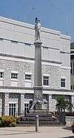 Memorial to Confederate soldiers
Politics
| Year | Republican | Democratic | Third Parties |
|---|---|---|---|
| 2016 | 56.6% 1,349 | 38.4% 914 | 5.0% 119 |
| 2012 | 41.9% 975 | 56.6% 1,319 | 1.6% 36 |
| 2008 | 43.3% 1,020 | 55.4% 1,304 | 1.3% 30 |
| 2004 | 48.0% 1,104 | 51.2% 1,179 | 0.8% 18 |
| 2000 | 43.6% 966 | 52.8% 1,168 | 3.6% 80 |
| 1996 | 31.1% 763 | 56.8% 1,394 | 12.1% 296 |
| 1992 | 34.7% 995 | 50.3% 1,442 | 15.1% 432 |
| 1988 | 43.7% 1,274 | 53.8% 1,567 | 2.5% 74 |
| 1984 | 54.5% 1,722 | 44.0% 1,391 | 1.6% 49 |
| 1980 | 37.7% 1,187 | 57.6% 1,813 | 4.8% 150 |
| 1976 | 37.1% 1,173 | 57.5% 1,820 | 5.4% 172 |
| 1972 | 63.7% 1,910 | 31.6% 948 | 4.7% 140 |
| 1968 | 43.1% 1,551 | 33.2% 1,195 | 23.6% 849 |
| 1964 | 35.8% 1,149 | 64.1% 2,055 | 0.1% 2 |
| 1960 | 47.9% 1,436 | 51.9% 1,558 | 0.2% 7 |
| 1956 | 56.3% 1,639 | 40.9% 1,189 | 2.8% 81 |
See also
References
- ↑ "American FactFinder". United States Census Bureau. Archived from the original on September 11, 2013. Retrieved 2008-01-31.
- ↑ "US Board on Geographic Names". United States Geological Survey. 2007-10-25. Retrieved 2008-01-31.
- 1 2 "State & County QuickFacts". United States Census Bureau. Retrieved January 5, 2014.
- ↑ "Find a County". National Association of Counties. Archived from the original on May 31, 2011. Retrieved 2011-06-07.
- ↑ "Roanoke Regional Partnership - Roanoke Virginia Live and Work". Retrieved 15 March 2016.
- ↑ Web Developer. "City Council". Retrieved 15 March 2016.
- ↑ City of Covington: News & Radio
- ↑ "Index of /". Retrieved 15 March 2016.
- ↑ National Park Service (2010-07-09). "National Register Information System". National Register of Historic Places. National Park Service.
- ↑ "US Gazetteer files: 2010, 2000, and 1990". United States Census Bureau. 2011-02-12. Retrieved 2011-04-23.
- ↑ "Covington, Virginia Köppen Climate Classification (Weatherbase)". Weatherbase. Retrieved 15 March 2016.
- ↑ "Population and Housing Unit Estimates". Retrieved June 9, 2017.
- ↑ "U.S. Decennial Census". United States Census Bureau. Archived from the original on May 12, 2015. Retrieved January 5, 2014.
- ↑ "Historical Census Browser". University of Virginia Library. Retrieved January 5, 2014.
- ↑ "Population of Counties by Decennial Census: 1900 to 1990". United States Census Bureau. Retrieved January 5, 2014.
- ↑ "Census 2000 PHC-T-4. Ranking Tables for Counties: 1990 and 2000" (PDF). United States Census Bureau. Retrieved January 5, 2014.
- ↑ anec_mar-apr07
- ↑ Report on the City of Covington – County of Alleghany Annexation Action, May 2011, Commission on Local Government, Commonwealth of Virginia
- ↑ Comprehensive Plan of Alleghany County, Virginia, May 2013
- ↑ "American FactFinder". United States Census Bureau. Archived from the original on September 11, 2013. Retrieved 2011-05-14.
- ↑ "CensusScope -- Population Growth". Retrieved 15 March 2016.
- ↑ City of Covington Archived 2010-07-09 at the Wayback Machine.
- ↑ http://uselectionatlas.org/RESULTS
External links

Coordinates: 37°47′10″N 79°59′20″W / 37.786225°N 79.988817°W