Dickenson County, Virginia
| Dickenson County, Virginia | ||
|---|---|---|
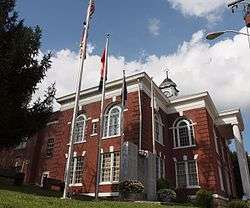 Dickenson County Courthouse in Clintwood | ||
| ||
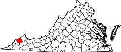 Location in the U.S. state of Virginia | ||
 Virginia's location in the U.S. | ||
| Founded | 1880 | |
| Named for | William J. Dickenson | |
| Seat | Clintwood | |
| Largest town | Clintwood | |
| Area | ||
| • Total | 334 sq mi (865 km2) | |
| • Land | 331 sq mi (857 km2) | |
| • Water | 3.1 sq mi (8 km2), 0.9% | |
| Population (est.) | ||
| • (2015) | 15,115 | |
| • Density | 45/sq mi (17/km2) | |
| Congressional district | 9th | |
| Time zone | Eastern: UTC−5/−4 | |
| Website |
www | |

Dickenson County is a county located in the Commonwealth of Virginia. As of the 2010 census, the population was 15,903.[1] Its county seat is Clintwood.[2]
History
Dickenson County, formed in 1880 from parts of Buchanan County, Russell County, and Wise County, is Virginia's youngest county. It was named for William J. Dickenson,[3] delegate to the Virginia General Assembly from Russell County, 1859–1861, 1865–1867, and 1877–1882.
Geography
According to the U.S. Census Bureau, the county has a total area of 334 square miles (870 km2), of which 331 square miles (860 km2) is land and 3.1 square miles (8.0 km2) (0.9%) is water.[4]
Districts
The county is divided into five magisterial districts with a supervisor elected for each district every four years. The districts are: Clintwood, Ervinton, Sandlick, Kenady, and Willis.
Adjacent counties
- Buchanan County, Virginia – northeast
- Russell County, Virginia – southeast
- Wise County, Virginia – southwest
- Pike County, Kentucky – northwest
National protected area
- Jefferson National Forest (part)
Major highways
Demographics
| Historical population | |||
|---|---|---|---|
| Census | Pop. | %± | |
| 1890 | 5,077 | — | |
| 1900 | 7,747 | 52.6% | |
| 1910 | 9,199 | 18.7% | |
| 1920 | 13,542 | 47.2% | |
| 1930 | 16,163 | 19.4% | |
| 1940 | 21,266 | 31.6% | |
| 1950 | 23,393 | 10.0% | |
| 1960 | 20,211 | −13.6% | |
| 1970 | 16,077 | −20.5% | |
| 1980 | 19,806 | 23.2% | |
| 1990 | 17,620 | −11.0% | |
| 2000 | 16,395 | −7.0% | |
| 2010 | 15,903 | −3.0% | |
| Est. 2016 | 14,968 | [5] | −5.9% |
| U.S. Decennial Census[6] 1790–1960[7] 1900–1990[8] 1990–2000[9] 2010–2013[1] | |||
As of the census[10] of 2000, there were 16,395 people, 6,732 households, and 4,887 families residing in the county. The population density was 49 people per square mile (19/km²). There were 7,684 housing units at an average density of 23 per square mile (9/km²). The racial makeup of the county was 98.96% White, 0.35% Black or African American, 0.12% Native American, 0.07% Asian, 0.05% from other races, and 0.45% from two or more races. 0.43% of the population were Hispanic or Latino of any race.
There were 6,732 households out of which 30.40% had children under the age of 18 living with them, 58.00% were married couples living together, 10.60% had a female householder with no husband present, and 27.40% were non-families. 25.30% of all households were made up of individuals and 11.30% had someone living alone who was 65 years of age or older. The average household size was 2.42 and the average family size was 2.88.
In the county, the population was spread out with 22.10% under the age of 18, 8.90% from 18 to 24, 27.60% from 25 to 44, 26.90% from 45 to 64, and 14.50% who were 65 years of age or older. The median age was 40 years. For every 100 females there were 95.70 males. For every 100 females age 18 and over, there were 93.60 males.
The median income for a household in the county was $23,431, and the median income for a family was $27,986. Males had a median income of $27,281 versus $17,695 for females. The per capita income for the county was $12,822. About 16.90% of families and 21.30% of the population were below the poverty line, including 26.80% of those under age 18 and 17.30% of those age 65 or over.
Education
Public High Schools
- Ridgeview High School, Haysi
Media
Radio stations
Politics
| Year | Republican | Democratic | Third parties |
|---|---|---|---|
| 2016 | 76.6% 4,932 | 20.7% 1,335 | 2.7% 173 |
| 2012 | 61.9% 4,274 | 35.8% 2,473 | 2.3% 157 |
| 2008 | 49.2% 3,324 | 48.5% 3,278 | 2.2% 151 |
| 2004 | 48.5% 3,591 | 50.8% 3,761 | 0.7% 54 |
| 2000 | 43.2% 3,122 | 54.7% 3,951 | 2.1% 153 |
| 1996 | 32.5% 2,229 | 57.0% 3,913 | 10.6% 726 |
| 1992 | 31.6% 2,574 | 59.4% 4,839 | 9.0% 730 |
| 1988 | 40.7% 3,091 | 58.7% 4,461 | 0.7% 52 |
| 1984 | 44.3% 3,921 | 54.8% 4,848 | 0.9% 75 |
| 1980 | 46.1% 3,687 | 52.3% 4,177 | 1.6% 131 |
| 1976 | 42.3% 3,471 | 55.8% 4,583 | 1.9% 155 |
| 1972 | 56.2% 3,633 | 42.0% 2,711 | 1.8% 118 |
| 1968 | 46.0% 3,412 | 45.3% 3,355 | 8.7% 648 |
| 1964 | 38.0% 2,143 | 61.8% 3,485 | 0.2% 11 |
| 1960 | 44.4% 2,203 | 55.6% 2,756 | 0.0% 1 |
| 1956 | 48.2% 3,444 | 51.7% 3,695 | 0.2% 14 |
| 1952 | 47.4% 2,913 | 52.3% 3,210 | 0.3% 21 |
| 1948 | 42.5% 2,197 | 56.9% 2,945 | 0.6% 30 |
| 1944 | 38.7% 1,762 | 61.2% 2,786 | 0.1% 6 |
| 1940 | 41.1% 1,785 | 58.7% 2,551 | 0.2% 7 |
| 1936 | 29.9% 1,146 | 70.1% 2,683 | 0.0% 1 |
| 1932 | 31.7% 1,228 | 68.0% 2,635 | 0.4% 15 |
| 1928 | 49.9% 1,868 | 50.2% 1,879 | |
| 1924 | 42.5% 1,294 | 53.1% 1,618 | 4.4% 135 |
| 1920 | 53.6% 1,067 | 45.4% 903 | 1.0% 20 |
| 1916 | 52.6% 753 | 45.4% 650 | 2.0% 28 |
| 1912 | 36.6% 398 | 48.6% 529 | 14.9% 162 |
Communities
Towns
Census-designated place
- Dante (mostly in Russell County)
Other unincorporated communities
- Caney Ridge
- Nora
Notable residents
- Justin Hamilton, former NFL player for Washington Redskins
- Darrell "Shifty" Powers, World War II (D-day) veteran, Company E ("Easy Company") 506th Parachute Infantry Regiment, U.S. 101st Airborne Division (portrayed in the HBO miniseries "Band of Brothers")
- Trazel Silvers, former professional basketball player for the Harlem Globetrotters and in Europe.
- Ralph Stanley[12] and Carter Stanley, The Stanley Brothers, bluegrass musicians
See also
References
- 1 2 "State & County QuickFacts". United States Census Bureau. Archived from the original on July 9, 2011. Retrieved January 2, 2014.
- ↑ "Find a County". National Association of Counties. Archived from the original on 2011-05-31. Retrieved 2011-06-07.
- ↑ Gannett, Henry (1905). The Origin of Certain Place Names in the United States. Govt. Print. Off. p. 106.
- ↑ "US Gazetteer files: 2010, 2000, and 1990". United States Census Bureau. 2011-02-12. Retrieved 2011-04-23.
- ↑ "Population and Housing Unit Estimates". Retrieved June 9, 2017.
- ↑ "U.S. Decennial Census". United States Census Bureau. Archived from the original on May 12, 2015. Retrieved January 2, 2014.
- ↑ "Historical Census Browser". University of Virginia Library. Retrieved January 2, 2014.
- ↑ "Population of Counties by Decennial Census: 1900 to 1990". United States Census Bureau. Retrieved January 2, 2014.
- ↑ "Census 2000 PHC-T-4. Ranking Tables for Counties: 1990 and 2000" (PDF). United States Census Bureau. Retrieved January 2, 2014.
- ↑ "American FactFinder". United States Census Bureau. Archived from the original on 2013-09-11. Retrieved 2011-05-14.
- ↑ Leip, David. "Dave Leip's Atlas of U.S. Presidential Elections". uselectionatlas.org. Retrieved 2018-08-19.
- ↑ Friskics-Warren, Bill (23 June 2016). "Ralph Stanley, Whose Mountain Music Gave Rise to Bluegrass, Dies at 89". The New York Times. Retrieved 24 June 2016.
External links
- Dickenson County Official Website
- Dickenson County Public Schools
- Dickenson County Discussion Board (DCDB) – Very active and popular local forum, in continuous operation since 1996.
- Dickenson Online – Portal of information related to Dickenson County.
- Ralph Stanley Museum & Traditional Mountain Music Center
Coordinates: 37°07′N 82°21′W / 37.12°N 82.35°W
Places adjacent to Dickenson County, Virginia | ||||||||||
|---|---|---|---|---|---|---|---|---|---|---|
| ||||||||||
Municipalities and communities of Dickenson County, Virginia, United States | ||
|---|---|---|
| Towns | | |
| CDP | ||
| Unincorporated communities | ||
| Footnotes | ‡This populated place also has portions in an adjacent county or counties | |
