Yanceyville, North Carolina
| Yanceyville, North Carolina | |
|---|---|
| Town | |
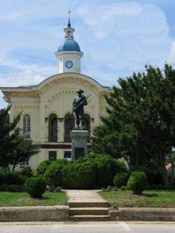 Caswell County Courthouse in Yanceyville | |
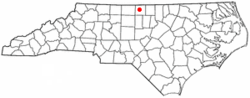 Location of Yanceyville, North Carolina | |
| Coordinates: 36°24′25″N 79°20′30″W / 36.40694°N 79.34167°WCoordinates: 36°24′25″N 79°20′30″W / 36.40694°N 79.34167°W | |
| Country | United States |
| State | North Carolina |
| County | Caswell |
| Area | |
| • Total | 5.6 sq mi (14.4 km2) |
| • Land | 5.5 sq mi (14.3 km2) |
| • Water | 0.04 sq mi (0.1 km2) |
| Elevation | 617 ft (188 m) |
| Population (2010) | |
| • Total | 2,039 |
| • Estimate (2016)[1] | 1,996 |
| • Density | 370/sq mi (140/km2) |
| Time zone | UTC-5 (Eastern (EST)) |
| • Summer (DST) | UTC-4 (EDT) |
| ZIP code | 27379 |
| Area code(s) | 336 |
| FIPS code | 37-76000[2] |
| GNIS feature ID | 0997688[3] |
| Website |
www |
Yanceyville is a town in and the county seat of Caswell County, North Carolina, United States.[4] The population was 2,039 at the 2010 census.[5]
History
It has been the county seat since 1792 (although the settlement was originally called Caswell Court House until 1833). The original Caswell County Courthouse has been renovated and provides offices for county departments. The new court house is located a few blocks north.
There remains uncertainty as to the person for whom Yanceyville is named. Some say it is named for James Yancey (1768–1829). Others claim it is named for his younger brother, Bartlett Yancey, Jr. (1785-1828).[6] A few believe the name honored the entire Yancey family, long prominent in the area.
In addition to the Caswell County Courthouse, the Graves House, William Henry and Sarah Holderness House, John Johnston House, Poteat House, Bartlett Yancey House, Yanceyville Historic District, and Melrose/Williamson House are listed on the National Register of Historic Places.[7][8]
Geography
Yanceyville is located at the center of Caswell County, at 36°24′25″N 79°20′30″W / 36.40694°N 79.34167°W (36.407037, -79.341545).[9] U.S. Route 158 passes through the town, leading east 22 miles (35 km) to Roxboro and west 22 miles (35 km) to Reidsville. North Carolina Highway 86 joins US 158 in a short bypass just north of the center of town and leads 29 miles (47 km) southeast to Hillsborough and 13 miles (21 km) north to Danville, Virginia. North Carolina Highway 62 passes through the eastern side of Yanceyville, leading northeast 12 miles (19 km) to Milton and south 25 miles (40 km) to Burlington.
According to the United States Census Bureau, Yanceyville has a total area of 5.6 square miles (14.4 km2), of which 5.5 square miles (14.3 km2) is land and 0.04 square miles (0.1 km2), or 0.57%, is water.[5]
Climate
| Climate data for Yanceyville, North Carolina (1981–2010 normals),[lower-alpha 1] | |||||||||||||
|---|---|---|---|---|---|---|---|---|---|---|---|---|---|
| Month | Jan | Feb | Mar | Apr | May | Jun | Jul | Aug | Sep | Oct | Nov | Dec | Year |
| Average high °F (°C) | 47.8 (8.8) |
51.6 (10.9) |
61.1 (16.2) |
70.3 (21.3) |
78.2 (25.7) |
87 (31) |
89.1 (31.7) |
87.4 (30.8) |
81 (27) |
70.6 (21.4) |
61.3 (16.3) |
50.3 (10.2) |
69.6 (20.9) |
| Average low °F (°C) | 28.2 (−2.1) |
30.3 (−0.9) |
37.8 (3.2) |
45.8 (7.7) |
55.1 (12.8) |
63.8 (17.7) |
68 (20) |
66.8 (19.3) |
58.7 (14.8) |
47.1 (8.4) |
38.5 (3.6) |
30.1 (−1.1) |
47.5 (8.6) |
| Average precipitation inches (mm) | 3.35 (85.1) |
3.3 (84) |
4.45 (113) |
4.07 (103.4) |
3.78 (96) |
3.52 (89.4) |
4.36 (110.7) |
5.8 (147) |
4.62 (117.3) |
3.45 (87.6) |
3.81 (96.8) |
3.49 (88.6) |
48 (1,220) |
| Average snowfall inches (cm) | 4 (10) |
1.1 (2.8) |
0.6 (1.5) |
0.0 (0) |
0 (0) |
0 (0) |
0 (0) |
0 (0) |
0 (0) |
0 (0) |
0 (0) |
1.6 (4.1) |
7.3 (18.5) |
| Source: xmACIS2 (Monthly Climate Normals)[10] | |||||||||||||
Demographics
| Historical population | |||
|---|---|---|---|
| Census | Pop. | %± | |
| 1910 | 338 | — | |
| 1950 | 1,391 | — | |
| 1960 | 1,113 | −20.0% | |
| 1970 | 1,274 | 14.5% | |
| 1990 | 1,973 | — | |
| 2000 | 2,091 | 6.0% | |
| 2010 | 2,039 | −2.5% | |
| Est. 2016 | 1,996 | [1] | −2.1% |
| U.S. Decennial Census[11] | |||
As of the census[2] of 2000, there were 2,091 people, 658 households, and 400 families residing in the town. The population density was 450.9 people per square mile (174.0/km²). There were 748 housing units at an average density of 161.3 per square mile (62.2/km²). The racial makeup of the town was 44.29% White, 53.99% African American, 0.33% Native American, 0.14% Asian, 0.33% from other races, and 0.91% from two or more races. Hispanic or Latino of any race were 1.00% of the population.
There were 658 households out of which 29.3% had children under the age of 18 living with them, 33.0% were married couples living together, 24.3% had a female householder with no husband present, and 39.2% were non-families. 36.8% of all households were made up of individuals and 19.0% had someone living alone who was 65 years of age or older. The average household size was 2.21 and the average family size was 2.88.
In the town, the population was spread out with 19.6% under the age of 18, 8.4% from 18 to 24, 32.9% from 25 to 44, 20.8% from 45 to 64, and 18.3% who were 65 years of age or older. The median age was 37 years. For every 100 females, there were 126.1 males. For every 100 females age 18 and over, there were 138.6 males.
The median income for a household in the town was $20,353, and the median income for a family was $26,417. Males had a median income of $24,632 versus $20,398 for females. The per capita income for the town was $16,956. About 23.3% of families and 27.7% of the population were below the poverty line, including 41.7% of those under age 18 and 24.1% of those age 65 or over.
In 2010, Yanceyville had the seventh-lowest median household income of all places in the United States with a population over 1,000.[12]
Activities
Between its amphitheater and town square, Yanceyville annually hosts the "Bright Leaf Hoedown". The "Hoedown" is a one-day outdoor festival held in late September featuring local food vendors, live entertainment, crafts and non-profit organizations, usually drawing more than 5,000 guests.
Yanceyville also hosts the Caswell County Parks and Recreation Department, which features a variety of sports and activities, especially for children, and the Caswell County Civic Center, a full-size, professionally equipped stage, 912-seat auditorium, meeting and banquet facilities for up to 500, lobby art gallery and accessories which has concerts, plays and social functions.[13] The town also has the county's senior center with recreational and fitness facilities built in 2009.[14]
Notable people
- Samuel Bason (1894-1986), late Yanceyville banker and businessman; member of the North Carolina State Senate, 1948-1956
- Neal Watlington (born 1922), Major League Baseball player
- Donna Edwards (born 1958), former U.S. representative
- Carl Willis (born 1960), former Major League Baseball Player and Current Pitching Coach of the Cleveland Indians
Notes
- ↑ Mean monthly maxima and minima (i.e. the expected highest and lowest temperature readings at any point during the year or given month) calculated based on data at said location from 1981 to 2010.
References
- 1 2 "Population and Housing Unit Estimates". Retrieved June 9, 2017.
- 1 2 "American FactFinder". United States Census Bureau. Retrieved 2008-01-31.
- ↑ "US Board on Geographic Names". United States Geological Survey. 2007-10-25. Retrieved 2008-01-31.
- ↑ "Find a County". National Association of Counties. Retrieved 2011-06-07.
- 1 2 "Geographic Identifiers: 2010 Demographic Profile Data (G001): Yanceyville town, North Carolina". U.S. Census Bureau, American Factfinder. Retrieved December 26, 2014.
- ↑ "Bartlett Yancey (1785-1828)". RootsWeb.com. Retrieved January 4, 2013.
- ↑ National Park Service (2010-07-09). "National Register Information System". National Register of Historic Places. National Park Service.
- ↑ M. Ruth Little (July 2014). "William Henry and Sarah Holderness House" (pdf). National Register of Historic Places - Nomination and Inventory. North Carolina State Historic Preservation Office. Retrieved 2015-07-01.
- ↑ "US Gazetteer files: 2010, 2000, and 1990". United States Census Bureau. 2011-02-12. Retrieved 2011-04-23.
- ↑ "NOAA 1981-2010 Climate Normals". NOAA Regional Climate Centers. Retrieved 2018-01-19.
- ↑ "Census of Population and Housing". Census.gov. Retrieved June 4, 2015.
- ↑ "US Census". Retrieved 18 January 2014.
- ↑ "Civic Center". County of Caswell, North Carolina. Retrieved January 9, 2013.
- ↑ "Senior Center". County of Caswell, North Carolina. Retrieved January 9, 2013.
External links
- Town of Yanceyville official website
- Caswell County Historical Association
- Caswell County Photograph Collection
- Caswell County Cemetery Census
Municipalities and communities of Caswell County, North Carolina, United States | ||
|---|---|---|
| Towns | 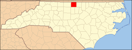 | |
| Unincorporated communities | ||