Charlier (Martian crater)
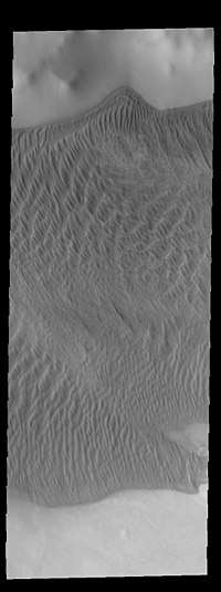 THEMIS image of Charlier crater showing part of the large sand sheet with surface dune forms on the crater floor | |
| Planet | Mars |
|---|---|
| Region | Mare Australe quadrangle |
| Coordinates | 68°34′S 168°40′W / 68.56°S 168.67°WCoordinates: 68°34′S 168°40′W / 68.56°S 168.67°W |
| Diameter | 106.28 km |
| Discoverer | Mariner 9 |
| Eponym | Carl V. Charlier, Swedish astronomer |
Charlier is a crater in the northwest of Mare Australe quadrangle of Mars, located in the south of Terra Sirenum and east of the 180th meridian. The crater is located at 68.56°S latitude and 168.67°W longitude. It is 106.28 km in diameter and was named after Henri A. Perrotin, a French astronomer who studied dark lineations on the planet. Its name was approved in 1973.[1]
Nearby prominent craters are Reynolds further south, Richardson almost southwest and Suess to the west. East is Chico Valles, the approximate area marking the boundaries of the terrae (lands) Sirenum and Aonia.
Dunes are dominant inside the crater, gullies are not commonly founded as to craters to the north. Most of the northern portion are mare up of layered material made by earlier glaciations.
The crater was first imaged by Mariner 9 in 1972, more detailed images were made later including the Viking Orbiters.
See also
- List of craters on Mars: A-G
- List of people with craters on Mars named after them
References
- ↑ "Charlier". Gazetteer of Planetary Nomenclature (USGS). International Astronomical Union. Retrieved April 26, 2018.
External links
